Jordanelle
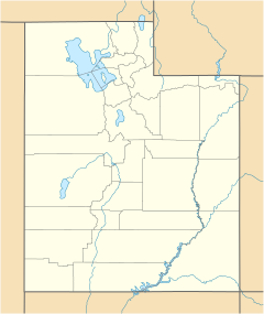
Location of the former community of Jordanelle within the State of Utah
Jordanelle was a community in northern Wasatch County, Utah, United States. [1]
Jordanelle was a community in northern Wasatch County, Utah, United States. [1]
Jordanelle was located along the former routing of US-40 and US-189, south of the former town of Hailstone and north of Heber City, [2] in the approximate current site of the Jordanelle Dam. [3] Almost all of the former town was submerged in 1995 by the waters of Jordanelle Reservoir, along with Hailstone and Keetley. About the only remains of the former community is an RV park.
Keetley is a ghost town located in northeastern Wasatch County, Utah, United States.

The Roan Cliffs are a series of desert mountains and cliffs in eastern Utah and western Colorado, in the western United States that are distinct from the Book Cliffs.
Hamiltons Fort is an unincorporated community in south-central Iron County, Utah, United States.

Eskdale is an unincorporated community in western Millard County, Utah, United States, just east of the Nevada border.
Black Rock is an unincorporated community and near-ghost town in the Beaver Bottoms in southern Millard County, Utah, United States, approximately 20 miles (32 km) north of Milford.
Chester is an unincorporated community in central Sanpete County, Utah, United States.
Birdseye is an unincorporated community in southeastern Utah County, Utah, United States.
Hanna is an unincorporated community in western Duchesne County, Utah, United States, on the Uintah and Ouray Indian Reservation.

Vivian Park is an unincorporated community in northeastern Utah County, Utah, United States.
The Kern Mountains are a mountain range primarily on the eastern edge of White Pine County, Nevada, United States, but extending slightly east into western Juab County, Utah.
Hailstone was a town in northern Wasatch County, Utah, United States.
Burmester is an unincorporated community in northeastern Tooele County, Utah, United States.
Rosette is an unincorporated ranching community in northwestern Box Elder County, Utah, United States.
Shivwits is an unincorporated community in west-central Washington County, Utah, United States. It is occupied by the Shivwits Band of Paiutes.

Maple Canyon is a canyon in the northeastern San Pitch Mountains in northern Sanpete County, Utah, United States Nearly all of the canyon, except the western end, is located within the Uinta National Forest. The mouth of the canyon is in the northwestern Sanpete Valley, south of Fountain Green and just northwest of the unincorporated community of Freedom, at an elevation of 6,017 feet (1,834 m).
Beaver Dam is an unincorporated community on the northeastern edge of Box Elder County, Utah, United States.
Crouse Creek is a stream in the Uinta Mountains near the eastern edge of Daggett County, Utah, United States.
Deadman Lake is a lake near the northern edge of Uintah County, Utah, United States.
Currant Creek is a stream in eastern Juab County and southern Utah County in northern Utah, United States.
Lost Creek State Park is a state park in northeastern Morgan County, Utah, United States, about 13 miles (21 km) northeast of city of Henefer and about 10 miles (16 km) northeast of the unincorporated community of Croydon, Utah.
![]() Media related to Jordanelle, Utah at Wikimedia Commons
Media related to Jordanelle, Utah at Wikimedia Commons
40°36′30″N111°24′40″W / 40.60833°N 111.41111°W
Municipalities and communities of Wasatch County, Utah, United States | ||
|---|---|---|
| Cities | 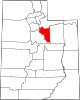 | |
| Towns | ||
| CDP | ||
| Unincorporated community | ||
| Indian reservation | ||
| Ghost towns | ||
| Footnotes | ‡This populated place also has portions in an adjacent county or counties | |
| | This article about a location in Utah is a stub. You can help Wikipedia by expanding it. |