Timber Lakes, Utah

Last updated

Timber Lakes, Utah
CDP
Timber Lakes Utah.jpeg
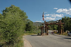
Entrance gate
Wasatch County Utah incorporated and unincorporated areas Timber Lakes highlighted.svg
Location in Wasatch County and the state of Utah
Coordinates: 40°28′32″N111°14′48″W / 40.47556°N 111.24667°W / 40.47556; -111.24667
Country United States
State Utah
County Wasatch
Area
  Total2.8 sq mi (7.2 km2)
  Land2.7 sq mi (7.0 km2)
  Water0.1 sq mi (0.2 km2)
Elevation
7,717 ft (2,352 m)
Population
 (2010)
  Total607
  Density220/sq mi (84/km2)
Time zone UTC-7 (Mountain (MST))
  Summer (DST) UTC-6 (MDT)
ZIP code
84032 [1]
Area code 435
FIPS code 49-76280 [2]
GNIS feature ID1852448 [3]

Timber Lakes is a census-designated place (CDP) in Wasatch County, Utah, United States. The population was 607 at the 2010 census, up from 289 in 2000.

Contents

Geography

According to the United States Census Bureau, the CDP has a total area of 2.8 square miles (7.3 km2), of which 2.7 square miles (7.0 km2) is land and 0.1 square miles (0.26 km2) (3.58%) is water. Timber Lakes is a private gated community in the mountains east of Heber City.

Demographics

As of the census [2] of 2000, there were 289 people, 108 households, and 81 families residing in the CDP. The population density was 107.2 people per square mile (41.4/km2). There were 485 housing units at an average density of 179.8/sq mi (69.4/km2). The racial makeup of the CDP was 97.92% White, 1.04% African American, 0.69% Native American and 0.35% Asian. Hispanic or Latino of any race were 4.50% of the population.

There were 108 households, out of which 33.3% had children under the age of 18 living with them, 71.3% were married couples living together, 2.8% had a female householder with no husband present, and 24.1% were non-families. 14.8% of all households were made up of individuals, and 0.9% had someone living alone who was 65 years of age or older. The average household size was 2.68 and the average family size was 3.06.

In the CDP, the population was spread out, with 27.7% under the age of 18, 3.8% from 18 to 24, 40.1% from 25 to 44, 23.5% from 45 to 64, and 4.8% who were 65 years of age or older. The median age was 34 years. For every 100 females, there were 118.9 males. For every 100 females age 18 and over, there were 117.7 males.

The median income for a household in the CDP was $55,208, and the median income for a family was $60,395. Males had a median income of $44,286 versus $30,625 for females. The per capita income for the CDP was $22,214. None of the families and 3.0% of the population were living below the poverty line, including no under eighteens and 42.9% of those over 64.

See also

Related Research Articles

Timber Hills is an unincorporated community and census-designated place (CDP) in Lebanon County, Pennsylvania, United States. The population was 360 at the 2010 census.

<span class="mw-page-title-main">Riverside, Utah</span> CDP in Utah, United States

Riverside is a census-designated place (CDP) in Box Elder County, Utah, United States. The population was 760 at the 2010 census.

<span class="mw-page-title-main">Cache, Utah</span> CDP in Utah, United States

Cache Junction is a census-designated place (CDP) in Cache County, Utah, United States. The population was 38 at the 2010 census. It is included in the Logan, Utah-Idaho (partial) Metropolitan Statistical Area.

<span class="mw-page-title-main">Cove, Utah</span> Census-designated place in Utah, United States

Cove is a census-designated place (CDP) in Cache County, Utah, United States. The population was 460 at the 2010 census. It is included in the Logan, Utah-Idaho Metropolitan Statistical Area.

<span class="mw-page-title-main">Peter, Utah</span> Census-designated place in Utah, United States

Peter is a census-designated place (CDP) on the west-central edge of Cache County, Utah, United States. The population was 324 at the 2010 census. It is included in the Logan, Utah-Idaho (partial) Metropolitan Statistical Area.

<span class="mw-page-title-main">Garden, Utah</span> CDP in Utah, United States

Garden is a census-designated place (CDP) in Rich County, Utah, United States. It includes the southernmost subdivision of Garden City at its northeast and the hamlet of Meadowville at its southeast; otherwise it is farmland. The population was 181 at the 2010 census.

Canyon Rim was a census-designated place (CDP) in Salt Lake County, Utah, United States, that was consolidated with neighboring Millcreek CDP in 2010. The consolidated CDP was incorporated in 2016. The population was 10,428 at the 2000 census, a minuscule decrease from the 1990 figure of 10,527. The area formerly in Canyon Rim CDP is located just south of Interstate 80 and the Sugar House neighborhood of Salt Lake City near the mouth of Parley's Canyon. Canyon rim is notable for Canyon Rim Park, Tanner Park, and Parleys Historic Nature Park.

Cottonwood West was a census-designated place (CDP) in Salt Lake County, Utah, United States. The CDP was situated between the cities of Holladay and Murray, which by the mid-2000s had annexed virtually all of the area between them.

<span class="mw-page-title-main">Granite, Utah</span> CDP in Utah, United States

Granite is a census-designated place (CDP) in Salt Lake County, Utah, United States, adjoining the City of Sandy on the east. As of the 2000 census, the CDP population was 2,018, a decrease from the 1990 population of 3,300 largely due to annexations by Sandy. Salt Lake County has designated a Granite “Community Council” for purposes of planning and development. The Granite Community Council includes the area within the CDP as well as the rest of Little Cottonwood Canyon, extending to Snowbird and Alta. In 2009 there was an effort to make Granite a township that ultimately failed.

<span class="mw-page-title-main">Halchita, Utah</span> CDP in Utah, United States

Halchita is a census-designated place (CDP) in San Juan County, Utah, United States. The population was 270 at the 2000 census.

<span class="mw-page-title-main">Tselakai Dezza, Utah</span> CDP in Utah, United States

Tselakai Dezza is a census-designated place (CDP) in San Juan County, Utah, United States. The population was 103 at the 2000 census.

<span class="mw-page-title-main">Snyderville, Utah</span> CDP in Utah, United States

Snyderville is a census-designated place (CDP) near the southwestern edge of Summit County, Utah, United States. Prior to the 2010 Census, the area was designated as South Snyderville Basin CDP. The population was 3,636 at the 2000 census.

<span class="mw-page-title-main">Fort Duchesne, Utah</span> CDP in Utah, United States

Fort Duchesne is a census-designated place (CDP) in Uintah County, Utah, United States. The population was 714 at the 2010 census, an increase from the 2000 figure of 621.

<span class="mw-page-title-main">Maeser, Utah</span> CDP in Utah, United States

Maeser is a census-designated place (CDP) in Uintah County, Utah, United States. The population was 2,855 at the 2000 census, a small increase over the 1990 figure of 2,598. The village is named after Karl Maeser, an educator.

<span class="mw-page-title-main">Elberta, Utah</span> CDP in Utah, United States

Elberta is a census-designated place (CDP) in Utah County, Utah, United States. It is part of the Provo–Orem Metropolitan Statistical Area. The population was 256 at the 2010 census. It was founded as Mt. Nebo. After the water failed in 1901, most of the early settlers moved away. It was purchased by Matthew B. Whitney, a native of New York, on November 7, 1907, and he renamed it "Elberta" after the peach cultivar.

<span class="mw-page-title-main">Lake Shore, Utah</span> CDP in Utah, United States

Lake Shore is a census-designated place (CDP) in Utah County, Utah, United States. It is part of the Provo–Orem Metropolitan Statistical Area. The population was 817 at the 2010 census.

<span class="mw-page-title-main">Palmyra, Utah</span> CDP in Utah, United States

Palmyra is a census-designated place (CDP) in Utah County, Utah, United States. It is part of the Provo–Orem Metropolitan Statistical Area. The population was 491 at the 2010 census. Palmyra is located directly west of Springville and northwest of Spanish Fork.

<span class="mw-page-title-main">Spring Lake, Utah</span> CDP in Utah, United States

Spring Lake is a census-designated place (CDP) in southern Utah County, Utah, United States. It is part of the Provo–Orem Metropolitan Statistical Area. The population was 458 at the 2010 census. It is an unincorporated part of Utah County, located just south of Payson and north of Santaquin.

<span class="mw-page-title-main">West Mountain, Utah</span> CDP in Utah, United States

West Mountain is a census-designated place (CDP) in Utah County, Utah, United States. It is part of the Provo–Orem Metropolitan Statistical Area. As of the 2010 census, the CDP population was 1,186. The town is at the base of West Mountain and bears its name.

<span class="mw-page-title-main">Hooper, Utah</span> City in Utah, United States

Hooper is a city in Weber County, Utah, United States, first called Muskrat Springs and later Hooperville for Captain William Henry Hooper, an early Utah delegate to Congress. The population was 9,087 at the 2020 census, up from the 2010 figure of 6,932. Prior to the city's incorporation on November 30, 2000, Hooper was an unincorporated census-designated place (CDP).

References

  1. "Timber Lakes UT ZIP Code". zipdatamaps.com. 2023. Retrieved June 16, 2023.
  2. 1 2 "U.S. Census website". United States Census Bureau . Retrieved January 31, 2008.
  3. "US Board on Geographic Names". United States Geological Survey. October 25, 2007. Retrieved January 31, 2008.