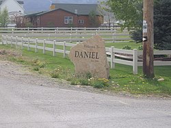
Daniel, Utah | |
---|---|
Coordinates: 40°27′35″N111°23′20″W / 40.45972°N 111.38889°W | |
Country | United States |
State | Utah |
County | Wasatch |
Settled | 1874 |
Given Township Status | 1997 |
Incorporated | February 28, 2006 |
Area | |
• Total | 3.29 sq mi (8.53 km2) |
• Land | 3.29 sq mi (8.53 km2) |
• Water | 0.00 sq mi (0.00 km2) |
Elevation | 5,748 ft (1,752 m) |
Population (2010) | |
• Total | 938 |
• Density | 327.16/sq mi (126.32/km2) |
Time zone | UTC-7 (Mountain (MST)) |
• Summer (DST) | UTC-6 (MDT) |
FIPS code | 49-18140 [3] |
GNIS feature ID | 2412402 [2] |
Website | http://danielutah.org/ |
Daniel is a town in Wasatch County, Utah, United States. The population was 938 at the 2010 census, at which time it was a township and census-designated place (CDP). Daniel incorporated as a town in February 2006. [4] Daniel was first settled in 1874. [5]
According to the United States Census Bureau, the CDP had a total area of 3.8 square miles (9.8 km2), all land.
Census | Pop. | Note | %± |
---|---|---|---|
2000 | 770 | — | |
2010 | 938 | 21.8% | |
2019 (est.) | 1,077 | [6] | 14.8% |
U.S. Decennial Census [7] |
As of the census [3] of 2000, there were 770 people, 238 households, and 209 families residing in the CDP. The population density was 205.3 people per square mile (79.3/km2). There were 259 housing units at an average density of 69.1 per square mile (26.7/km2). The racial makeup of the CDP was 97.14% White, 0.26% African American, 0.52% Native American, 0.52% Asian, 0.13% from other races, and 1.43% from two or more races. Hispanic or Latino of any race were 3.51% of the population.
There were 238 households, out of which 42.0% had children under the age of 18 living with them, 79.8% were married couples living together, 5.5% had a female householder with no husband present, and 11.8% were non-families. 9.2% of all households were made up of individuals, and 2.9% had someone living alone who was 65 years of age or older. The average household size was 3.23, and the average family size was 3.45.
In the CDP, the population was spread out, with 29.5% under 18, 10.8% from 18 to 24, 24.8% from 25 to 44, 25.7% from 45 to 64, and 9.2% who were 65 years of age or older. The median age was 35 years. For every 100 females, there were 107.0 males. For every 100 females aged 18 and over, there were 112.9 males.
The median income for a household in the CDP was $60,000, and the median income for a family was $59,773. Males had a median income of $43,542 versus $16,667 for females. The per capita income for the CDP was $21,764. About 4.0% of families and 5.1% of the population were below the poverty line, including 5.0% of those under age 18 and none aged 65 or over.
At the time of Daniel's incorporation, the Utah Population Estimates Committee produced an official estimate of the town's population of 696. [8]
Nenahnezad is a census-designated place (CDP) in San Juan County, New Mexico, United States. The population was 726 at the 2000 census. Nenahnezad is a chapter community just to the south of Fruitland, between the towns of Farmington and Shiprock. It is part of the Farmington Metropolitan Statistical Area.
Fruit Hill is a census-designated place (CDP) in Anderson Township, Hamilton County, Ohio, United States. The population was 3,748 at the 2020 census.
Northbrook is a census-designated place (CDP) in Colerain Township, Hamilton County, Ohio, United States. The population was 10,912 at the 2020 census.
Northgate is a census-designated place (CDP) in Colerain Township, Hamilton County, Ohio, United States. The population was 7,277 at the 2020 census.
Masury is an unincorporated community and census-designated place in Brookfield and Hubbard Townships in eastern Trumbull County, Ohio, United States. The population was 2,001 at the 2020 census. It is part of the Youngstown–Warren metropolitan area.
Sequoyah is a census-designated place (CDP) in Rogers County, Oklahoma, United States. The population was 671 at the 2000 census.
South Willard is a census-designated place (CDP) in Box Elder County, Utah, United States. The population was 1,571 at the 2010 census.
Avon is a census-designated place (CDP) in Cache County, Utah, United States. The population was 390 at the 2020 census. It is included in the Logan, Utah-Idaho (partial) Metropolitan Statistical Area.
Halchita is a census-designated place (CDP) in San Juan County, Utah, United States. The population was 270 at the 2000 census.
Montezuma Creek is a census-designated place (CDP) in San Juan County, Utah, United States. The population was 335 at the 2010 census, a decrease from the 2000 figure of 507.
Maeser is a census-designated place (CDP) in Uintah County, Utah, United States. The population was 4,081 at the 2020 census, an increase over the 2010 figure of 3,601. The village is named after Karl Maeser, an educator.
Benjamin is a census-designated place (CDP) in Utah County, Utah, United States. It is part of the Provo–Orem Metropolitan Statistical Area. The population was 1,145 at the 2010 census.
Lake Shore is a census-designated place (CDP) in Utah County, Utah, United States. It is part of the Provo–Orem Metropolitan Statistical Area. The population was 817 at the 2010 census.
Palmyra is a census-designated place (CDP) in Utah County, Utah, United States. It is part of the Provo–Orem Metropolitan Statistical Area. The population was 491 at the 2010 census. Palmyra is located directly west of Springville and northwest of Spanish Fork.
West Mountain is a census-designated place (CDP) in Utah County, Utah, United States. It is part of the Provo–Orem Metropolitan Statistical Area. As of the 2010 census, the CDP population was 1,186. The town is at the base of West Mountain and bears its name.
Como is a census-designated place (CDP) in the town of Geneva, Walworth County, Wisconsin, United States. The population was 2,356 at the 2020 census.
Star Valley Ranch is a town in Lincoln County, Wyoming, United States. The population was 1,866 at the 2020 census. It was incorporated on November 8, 2005; at the 2000 census, it was only a census-designated place (CDP).
Westerly is a census-designated place (CDP) in the town of Westerly in Washington County, Rhode Island, United States. The population was 17,682 at the 2000 census. The CDP includes the majority of the town of Westerly's population, with only the rural eastern and coastal southern portions of towns excluded.
Windsor is a village and former town in Dane County, Wisconsin. The population was 8,754 at the time of the 2020 census. The communities of Lake Windsor, Morrisonville, and Token Creek are located within the village. Windsor voted to incorporate as a village on November 3, 2015; prior to its incorporation, it was a town, and a portion of the town was a census-designated place. Windsor is a part of the Census Bureau's Madison metropolitan statistical area.
Oljato-Monument Valley is a census-designated place (CDP) in San Juan County, Utah, United States. The population was 864 at the 2000 census.
{{cite web}}
: Missing or empty |title=
(help)