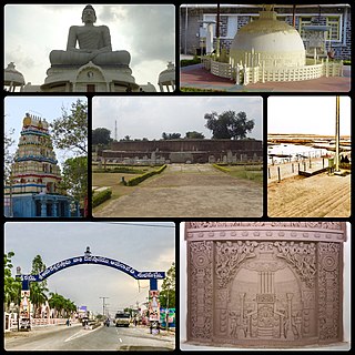
Amaravathi is a village on the banks of the Krishna River, in the Palnadu district of the Indian state of Andhra Pradesh. It is the headquarters of Amaravathi mandal, and forms part of the Andhra Pradesh Capital Region with its headquarters at new Amaravati 35 km (22 mi) east, whose name is also borrowed from that of the older Amaravathi.

Dharanikota is a village in Palnadu district of the Indian state of Andhra Pradesh. It is located in Amaravathi mandal of Guntur revenue division. The village forms a part of Andhra Pradesh Capital Region, under the jurisdiction of APCRDA.
Amruthalur is a village in Guntur district of the Indian state of Andhra Pradesh. It is the headquarters of Amruthaluru mandal in Tenali revenue division. The village forms a part of Andhra Pradesh Capital Region and is under the jurisdiction of APCRDA.

Attalur is a village in Palnadu district of the Indian state of Andhra Pradesh. It is located in Amaravathi mandal of Guntur revenue division. The village forms a part of Andhra Pradesh Capital Region, under the jurisdiction of APCRDA.

Vejendla is a village in Guntur district of the Indian state of Andhra Pradesh. It is supposed to be the headquarters of Chebrolu mandal in Tenali revenue division. It is located in Chebrolu mandal of Tenali revenue division.
Pedapalem is a village in Palnadu district of the Indian state of Andhra Pradesh. It is the headquarters of Atchampet mandal in Guntur revenue division. The village forms a part of Andhra Pradesh Capital Region and is under the jurisdiction of APCRDA.
Nemalikallu is a village in Palnadu district of the Indian state of Andhra Pradesh. It is located in Amaravathi mandal of Guntur revenue division. The village forms a part of Andhra Pradesh Capital Region, under the jurisdiction of APCRDA.
Chamarru is a village in Palnadu district of the Indian state of Andhra Pradesh. It is the headquarters of Atchampet mandal in Guntur revenue division. The village forms a part of Andhra Pradesh Capital Region and is under the jurisdiction of APCRDA.
Malladi is a village in Palnadu district of the Indian state of Andhra Pradesh. It is located in Amaravathi mandal of Guntur revenue division. The village forms a part of Andhra Pradesh Capital Region, under the jurisdiction of APCRDA.

Kaza is a village in Guntur district of the Indian state of Andhra Pradesh. It is located in Mangalagiri mandal part of Mangalagiri Tadepalle Municipal Corporation part of Guntur revenue division. The great saint krishna Narayana Teertha born here.
Narakodur is a village in Guntur district of the Indian state of Andhra Pradesh. It is the headquarters of Bollapalle mandal in Tenali revenue division. It is located in Chebrolu mandal of Tenali revenue division.
Ambadipudi is a village in Palnadu district of the Indian state of Andhra Pradesh. It is the headquarters of Atchampet mandal in Guntur revenue division. The village forms a part of Andhra Pradesh Capital Region and is under the jurisdiction of APCRDA.

Endroyi is a village in Guntur district of the Indian state of Andhra Pradesh. It is located in Amaravathi mandal of Guntur revenue division. The village forms a part of Andhra Pradesh Capital Region, under the jurisdiction of APCRDA.

Vykuntapuram, also spelled as Vaikuntapuram, is a village in Guntur district of the Indian state of Andhra Pradesh. It is located in Amaravathi mandal of Guntur revenue division. The village forms a part of Andhra Pradesh Capital Region, under the jurisdiction of APCRDA.
Didugu is a village in Palnadu district of the Indian state of Andhra Pradesh. It is located in Amaravathi mandal of Guntur revenue division. The village forms a part of Andhra Pradesh Capital Region, under the jurisdiction of APCRDA.

Narukullapadu is a village in Palnadu district of the Indian state of Andhra Pradesh. It is located in Amaravathi mandal of Guntur revenue division. Kondaveeti Vagu river flows through the village, which frequently floods causing significant damage to crops and risking lives. The village forms a part of Andhra Pradesh Capital Region, under the jurisdiction of APCRDA.
Lingapuram is a village in Palnadu district of the Indian state of Andhra Pradesh. It is located in Amaravathi mandal of Guntur revenue division. The village forms a part of Andhra Pradesh Capital Region, under the jurisdiction of APCRDA.

Pedamadduru is a village in Palnadu district of the Indian state of Andhra Pradesh. It is located in Amaravathi mandal of Guntur revenue division. The village forms a part of Andhra Pradesh Capital Region, under the jurisdiction of APCRDA.
Chinaravuru is an area of Tenali in Guntur district of the Indian state of Andhra Pradesh. It is located in Tenali Mandal of Tenali revenue division. It has now become the attractive and one of the important parts of the Tenali city. The park named Chinnaravuru park located here is the biggest attractive part of the Tenali. It forms a part of Andhra Pradesh Capital Region.
Unguturu is a village in Palnadu district of the Indian state of Andhra Pradesh. It is located in Amaravathi mandal of Guntur revenue division. The village forms a part of Andhra Pradesh Capital Region, under the jurisdiction of APCRDA.
