Kaduna South Local Government Area (LGA) shares boundaries with three Local Government Areas: Kaduna North LGA to the north, Chikun LGA to the south and Igabi LGA to the northwest, respectively.[5][6] The name of the chairman of Kaduna south is Rayyan Hussain.[7]
Administrative subdivisions
Kaduna South Local Government Area consists of 13 subdivisions (second-order administrative divisions or Wards), namely:[8]
It has an area of about 46.2km2 and a population of 402,731 as of 2006 census.[3]
People
The area has a mixed population, comprising Nigerian ethnic groups amongst which include: Adara, Atyap, Bajju, Gbagyi, Ham, Hausa, Idoma, Igala, Igbo, Nupe and Yoruba, amongst others, practicing different religion.
Geography
With an average temperature of 33 degrees Celsius, Kaduna South Local Government Area has a total size of roughly 59 square kilometers. With an estimated elevation of 650 meters above sea level, the Local Government Area's landscape is primarily flat. The two main seasons in Kaduna South Local Government Area are the dry and the rainy seasons.[9]
Climate condition
Kaduna South has a tropical climate, with significantly less rainfall in winter than in summer. This climate is classified as Aw according to the Köppen-Geiger system. The average temperature is 25.2°C (77.4°F), with annual precipitation of approximately 998 mm (39.3 in). The climate is moderate, with summers that are not easily defined.[10]
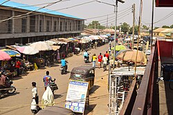
Economic Activities
Trade is a vital feature of the economy of Kaduna South, where a variety of commodities are bought and sold in its markets: Makera, Kakuri, and Kasuwararci. The important enterprises engaged in by the people include trading, rearing of animals and craftsmanship.[9]
Kakuri Hausa is a populated settlement in Kaduna South Local Government Area of Kaduna State, Nigeria, forming part of the Kaduna South region and the wider Kaduna metropolis where residents live and engage in social and economic activities. The area is located at approximately 10° 28′ 30″ North latitude and 7° 25′ 10″ East longitude (10.47511°N, 7.41959°E) and experiences a tropical savanna (Aw) climate characterized by distinct wet and dry seasons.[20]
This page is based on this Wikipedia article Text is available under the CC BY-SA 4.0 license; additional terms may apply. Images, videos and audio are available under their respective licenses.