Kaeng Chet Khwae National Park

Last updated
Kaeng Chet Khwae National Park
IUCN category II (national park)
Thailand adm location map.svg
Red pog.svg
Location within Thailand
Location Phitsanulok Province, Thailand
Coordinates 17°05′35″N100°37′22″E / 17.09306°N 100.62278°E / 17.09306; 100.62278 Coordinates: 17°05′35″N100°37′22″E / 17.09306°N 100.62278°E / 17.09306; 100.62278
Area261 km²
Visitors16,551(in 2007)

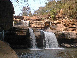
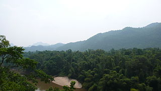
Kaeng Chet Khwae National Park is a national park in Phitsanulok Province, Thailand. [1]

National park Park used for conservation purposes of animal life and plants

A national park is a park in use for conservation purposes. Often it is a reserve of natural, semi-natural, or developed land that a sovereign state declares or owns. Although individual nations designate their own national parks differently, there is a common idea: the conservation of 'wild nature' for posterity and as a symbol of national pride.

Phitsanulok Province Province in Thailand

Phitsanulok, one of Thailand's seventy-six provinces, lies in upper central Thailand. It borders Sukhothai and Uttaradit on the north, Loei and Phetchabun to the east, and Phichit and Kamphaeng Phet to the south. In the northeast it borders Laos.

Thailand Constitutional monarchy in Southeast Asia

Thailand, officially the Kingdom of Thailand and formerly known as Siam, is a country at the centre of the Southeast Asian Indochinese peninsula composed of 76 provinces. At 513,120 km2 (198,120 sq mi) and over 68 million people, Thailand is the world's 50th-largest country by total area and the 21st-most-populous country. The capital and largest city is Bangkok, a special administrative area. Thailand is bordered to the north by Myanmar and Laos, to the east by Laos and Cambodia, to the south by the Gulf of Thailand and Malaysia, and to the west by the Andaman Sea and the southern extremity of Myanmar. Its maritime boundaries include Vietnam in the Gulf of Thailand to the southeast, and Indonesia and India on the Andaman Sea to the southwest. It is a unitary state. Although nominally the country is a constitutional monarchy and parliamentary democracy, the most recent coup, in 2014, established a de facto military dictatorship under a junta.

Contents

Topography

The park consists of mountains and forest which also includes scenic steep valleys, rugged mountains, rocky terrain and waterfalls. It occupies 261 km2. [2]

Forest

The park contains mixed deciduous, deciduous, hill evergreen and dry evergreen forests. [2] It is divided into the following forest parks:

Flora and fauna

Plant species include teak, Afzelia xylocarpa Roxb., Xylia xylocarpa (Deang), Pterocarpus macrocarpus (pradoo) and rubber trees. [2]

Teak species of plant

Teak is a tropical hardwood tree species placed in the flowering plant family Lamiaceae. Some forms of teak are known as Burmese teak, Central Province teak, as well as Nagpur teak. T. grandis is a large, deciduous tree that occurs in mixed hardwood forests. It has small, fragrant white flowers arranged in dense clusters (panicles) at the end of the branches. These flowers contain both types of reproductive organs. The large, papery leaves of teak trees are often hairy on the lower surface. Teak wood has a leather-like smell when it is freshly milled and is particularly valued for its durability and water resistance. The wood is used for boat building, exterior construction, veneer, furniture, carving, turnings, and other small wood projects.

<i>Pterocarpus macrocarpus</i> species of plant

Pterocarpus macrocarpus, or the Burma padauk, is a tree native to the seasonal tropical forests of southeastern Asia: in Myanmar, Laos, Cambodia, Thailand, and Vietnam. It has been naturalized in India and the Caribbean.

Among the animal species in the park are: Muntiacus muntjak, wild boar, monkey, langur, masked palm civet, porcupine, rabbit and many bird, reptile and fish species. [2]

Wild boar species of mammal

The wild boar, also known as the wild swine, Eurasian wild pig, or simply wild pig, is a suid native to much of Eurasia, North Africa, and the Greater Sunda Islands. Human intervention has spread its distribution further, making the species one of the widest-ranging mammals in the world, as well as the most widely spread suiform. Its wide range, high numbers, and adaptability mean that it is classed as least concern by the IUCN and it has become an invasive species in part of its introduced range. The animal probably originated in Southeast Asia during the Early Pleistocene, and outcompeted other suid species as it spread throughout the Old World.

Monkey animal of the "higher primates" (the simians), but excluding the apes

Monkey is a common name that may refer to groups or species of mammals, in part, the simians of infraorder Simiiformes. The term is applied descriptively to groups of primates, such as families of new world monkeys and old world monkeys. Many monkey species are tree-dwelling (arboreal), although there are species that live primarily on the ground, such as baboons. Most species are also active during the day (diurnal). Monkeys are generally considered to be intelligent, especially the old world monkeys of Catarrhini.

Masked palm civet species of mammal

The masked palm civet or gem-faced civet is a civet species native to the Indian Subcontinent and Southeast Asia. It is classified by IUCN in 2008 as Least Concern as it occurs in many protected areas, is tolerant to some degree of habitat modification, and widely distributed with presumed large populations that are unlikely to be declining.

Related Research Articles

Tha Yang District District in Phetchaburi, Thailand

Tha Yang is a district (amphoe) in the southern part of Phetchaburi Province, western Thailand.

Wat Bot District District in Phitsanulok, Thailand

Wat Bot is a district (amphoe) in the northern part of Phitsanulok Province, central Thailand.

Wang Thong District District in Phitsanulok, Thailand

Wang Thong is a district (amphoe) of Phitsanulok Province, central Thailand.

Wang Thong River river in Thailand

The Wang Thong River is a river in Thailand. Its source lies in the Phetchabun Mountains in the Khao Kho District, Thailand. It flows through Thung Salaeng Luang National Park and forms Namtok Sri Dit and Namtok Kaeng Sopha in the Wang Thong District of Phitsanulok Province, and finally flows through into the Bang Krathum District, passing through Ban Sam Ruen and on to the border of Phitsanulok and Phichit, where it drains into the Nan River at 16°31′06″N100°19′36″E. The land drained by the Wang Thong River is part of the Nan Basin and the Chao Phraya Watershed.

Mae Yom National Park national park of Thailand

Mae Yom National Park is a national park in Phrae Province, Thailand. The Yom River flows through the park. The land is mountainous and fertile, and there are naturally grown teak trees.

Thung Salaeng Luang National Park national park of Thailand

Thung Salaeng Luang National Park is a 1,262 km2 national park in Phitsanulok and Phetchabun Provinces of Thailand. It encompasses substantial portions of Wang Thong and Lom Sak Districts.

Namtok Chat Trakan National Park

Namtok Chat Trakan National Park is a national park located in Phitsanulok Province of Thailand, established in 1987. It encompasses a substantial portion of Amphoe Chat Trakan.

Ban Yang is a subdistrict in the Wat Bot District of Phitsanulok Province, Thailand.

Khan Chong is a subdistrict in Wat Bot District of Phitsanulok Province, Thailand.

Tenasserim Hills

Tenasserim Hills or Tenasserim Range is the geographical name of a roughly 1,700 km long mountain chain, part of the Indo-Malayan mountain system in Southeast Asia.

Doi Phu Nang National Park

Doi Phu Nang National Park is a national park in Dok Khamtai, Pong and Chiang Muan Districts, Phayao Province, Thailand.

Phi Pan Nam Range mountain range in Thailand and Laos

The Phi Pan Nam Range, also Pee Pan Nam, is a 400 km (249 mi) long system of mountain ranges in the eastern half of the Thai highlands. It is mostly in Thailand, although a small section in the northeast is within Sainyabuli and Bokeo Provinces, Laos.

Khuean Srinagarindra National Park

Khuean Srinagarindra National Park is a national park in Kanchanaburi Province, Thailand. The park, centred on the Srinagarind Reservoir, is part of the Western Forest Complex protected area.

Tat Mok National Park

Tat Mok National Park is a national park in Phetchabun Province, Thailand. Established on 30 October 1998, it is the 87th national park in Thailand.

Tham Pla–Namtok Pha Suea National Park

Tham Pla–Namtok Pha Suea National Park is a national park in Mae Hong Son Province, Thailand. It is home to caves, waterfalls and steep mountain terrain.

Huai Nam Dang National Park national park of Thailand

Huai Nam Dang National Park is a national park in Thailand's Chiang Mai and Mae Hong Son Provinces. This mountainous park features scenic mountain viewpoints, waterfalls, and hot springs.

Lam Nam Nan National Park

Lam Nam Nan National Park is a national park in Thailand's Phrae and Uttaradit provinces. The park is home to rugged mountains and the reservoir of the Sirikit Dam.

Mae Wa National Park

Mae Wa National Park is a national park in Thailand's Lampang and Tak provinces. This mountainous park features scenic mountain viewpoints, waterfalls and caves.

Na Yung–Nam Som National Park

Na Yung–Nam Som National Park is a national park in Nam Som District, Udon Thani Province, Thailand.

Si Nan National Park

Si Nan National Park is a national park in Thailand's Nan Province. This mountainous park is home to steep cliffs and a long section of the Nan River.

References

  1. "Kaeng Chet Khwae National Park". Tourism Authority of Thailand (TAT). Retrieved 8 August 2019.
  2. 1 2 3 4 "Kaeng Chet Khwae National Park". Department of National Parks (Thailand). Archived from the original on 26 March 2016. Retrieved 24 May 2017.