
Brunei, formally Brunei Darussalam, is a country located on the north coast of the island of Borneo in Southeast Asia. Apart from its South China Sea coast, it is completely surrounded by the Malaysian state of Sarawak. It is separated into two parts by the Sarawak district of Limbang. Brunei is the only sovereign state entirely on Borneo; the remainder of the island is divided between Malaysia and Indonesia. As of 2020, its population was 460,345, of whom about 100,000 live in the capital and largest city, Bandar Seri Begawan. The government is an absolute monarchy ruled by its Sultan, entitled the Yang di-Pertuan, and implements a combination of English common law and sharia law, as well as general Islamic practices.

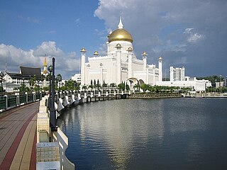
Bandar Seri Begawan (formerly known as Brunei Town; is the capital and largest city of Brunei. It is officially governed as a municipality. Bandar Seri Begawan has an estimated population of 100,700, and including the whole Brunei-Muara District, the metro area has an estimated population of 279,924, over half the population of the country.

Belait District, or simply Belait, is the largest as well as the westernmost district in Brunei. It has an area of 2,727 square kilometres (1,053 sq mi) and the population of 69,062 as of 2016. The administrative town is Kuala Belait, located at the mouth of the Belait River. The district is commonly associated with the oil and gas industry of the country, mainly concentrated near the town of Seria.
Brunei-Muara District or simply Brunei-Muara is one of the four districts of Brunei. It has the smallest area among the four districts, with 571 square kilometres (220 sq mi), yet is the most populous, with 289,630 people as of 2016. Bandar Seri Begawan, the country's capital, is located in this district, which is also de facto the district's capital. It is also home to Brunei International Airport, the country's only international airport, as well as Muara Port, the main and only deep-water port in the country. The Brunei River flows within this district and is home to Kampong Ayer, the traditional historic settlement on stilts above the river.

Brunei International Airport (BIA) is the primary and only airport in the sovereign nation of Brunei Darussalam, on the island of Borneo. Located near Bandar Seri Begawan in the Brunei-Muara District, it serves as the home base and hub for Royal Brunei Airlines (RB). Additionally, the Royal Brunei Air Force (RBAF) is also based at the Rimba Airbase, which is located within the airport's environs. The airport serves international destinations across Asia and Oceania, as well as flights to the Middle East and London Heathrow.
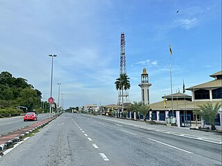
Kuala Belait, officially known as Kuala Belait Town, is an administrative town in Mukim Kuala Belait, Belait District, Brunei. The population of the town proper was 4,259 in 2016. Kuala Belait is officially under the Seria and Kuala Belait Municipal Department, as well as a village under the mukim of the same name. Kuala Belait is located 85 kilometres (53 mi) west of the country's capital Bandar Seri Begawan, and 20 kilometres (12 mi) west of Seria. It is also in the westernmost part of country, near the mouth of the Belait River.

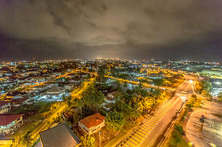
Seria or officially known as Seria Town, formerly known as Wild Pigeon's Field, is a town in Mukim Seria, Belait District, Brunei. The town is located within a mangrove swamp, surrounded by the Seria oil field and 65 kilometres (40 mi) west from the country's capital Bandar Seri Begawan. The name Seria was given by the British authorities, an acronym for the South East Reserved Industrial Area.

The administrative divisions of Brunei mainly consist of daerah (districts), mukim (subdistricts) and kampung or kampong (villages). They are organised hierarchically, with daerah being the first level and kampong the third level.
Mumong is a residential suburb of Kuala Belait, the principal town of Belait District, Brunei. It comprises the original Mumong settlement, as well as the Mumong public housing estate of the Landless Indigenous Citizens' Housing Scheme. However, it officially consists of two village subdivisions, namely Mumong 'A' and Mumong 'B', which are under the mukim of Kuala Belait.

Rasau is an area in Brunei. The area contains one of the two oil fields of Brunei, the Rasau Field, and a small village, Kampong Rasau, which has a population of 103.
Sungai Tujoh, also abbreviated as Sg. Tujoh, is the westernmost point of Brunei. It is located in the Belait district. The name of the area is derived from two Bruneian Malay words - Sungai, which means river or stream, and Tujoh or the number seven. Literally, Sungai Tujoh is translated as the Seventh River or Seventh Stream in English.

Anduki Airfield is a domestic airfield and heliport located in Seria, a town in the Belait District of Brunei Darussalam. It is operated by Brunei Shell Petroleum (BSP), and uses Sikorsky S-92 and AgustaWestland AW139 helicopters in support of servicing offshore oil platforms. Brunei Shell Petroleum replaced the grass airstrip with a sealed instrument runway in 2008. Future upgrades include the addition of runway lighting, and an enhanced instrument approach procedure.
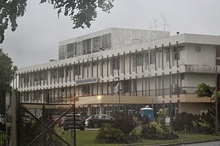
Suri Seri Begawan Hospital, also known as Kuala Belait Hospital, is a government hospital located in Kuala Belait, Mukim Kuala Belait, Belait District of Brunei. It is also the 2nd largest hospital in the country, which accommodates 183 beds. The hospital provides secondary health care and other various specialties.
Municipalities in Brunei are settlements which have been incorporated by the government to run as municipalities. They are independent from the hierarchy of the country's subdivisions but nevertheless overlap with mukims and villages, the second- and third-level administrative divisions of Brunei. The governing body of a municipality is municipal department which is a government department under the Ministry of Home Affairs; the head is a chairman which is equivalent to mayor.
Kampong Sungai Liang is a village in Belait District, Brunei, about 40 kilometres (25 mi) from the district's principal town Kuala Belait and 20 kilometres (12 mi) from the oil town Seria. The population was 910 in 2016. It is one of the villages within Mukim Liang. The postcode is KC1135.

The Belait River is a river in Belait District, Brunei. It is the longest of the four main rivers in the country.
The Fire and Rescue Department, also known as Brunei Fire and Rescue Department, is a federal agency of Brunei responsible for firefighting, animal rescue and technical rescue. Bomba is a Malay word derived from the Portuguese bombeiros which means 'firefighters'. The department's main headquarters are in Bandar Seri Begawan.

The Kuala Belait Port, also known as Kuala Belait Wharf, is a port operated by both the Brunei Shell Petroleum (BSP) and Maritime and Port Authority Brunei Darussalam (MPABD). The port can only accommodate low-draught ships. It is one of the only three existing ports in the country.

