
Idukki is one of the 14 districts in the Indian state of Kerala in the southwest of the country. It is the largest district in Kerala and lies amid the Cardamom Hills of Western Ghats in Kerala. Idukki district contains two municipal towns – Kattappana and Thodupuzha, and five taluks.

Idukki is a township in Idukki district near to the district headquarter Painavu in the state of Kerala, southern India. The township consists of the towns of Cheruthoni, Painavu, Thadiyampadu, Idukki proper and Vazhathope. Idukki is an administrative town, but the district headquarters is located at Painavu.
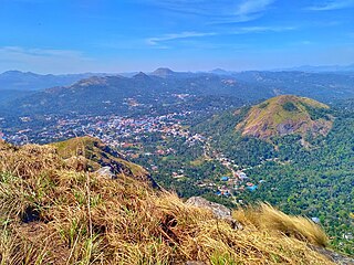
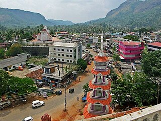
Kattappana stands as a vibrant municipal town nestled within the lush embrace of the Sahyadri in Kerala state, India. Positioned at an elevation of approximately 2,788.71–2,952.76 feet (850.00–900.00 m) above sea level, it proudly serves as the principal urban hub in the high ranges of Idukki district. This town holds the distinction of being the second to attain municipal status in the Idukki District. Renowned for its bustling commerce, Kattappana thrives on agriculture and spice production, shaping its identity as a significant commercial center.

Ayyappancoil, also spelt Ayyappankovil is a village in newly formed Idukki taluk in Idukki district in the Indian state of Kerala. The place is popular for having a suspension bridge with a length of 200 meters and an old historic Sastha temple on the banks of Periyar river.

Elappara is a town in Idukki district in the southwestern Indian state of Kerala. It is one of the panchayaths in Peerumedu taluk. The area is marked by a cool climate as the region is situated at an elevation of over 1,000 m (3,300 ft) above sea level. Elappara is famous for its vast tea plantations.
Rajakkad is a town in the Idukki district in the Indian state of Kerala situated in the Western Ghats.
Upputhara is a village in Idukki district in the Indian state of Kerala. Upputhara panchayat, belonging to the block panchayat of Kattappana, is situated in the southern part of Idukki district in the Peermade taluk. The panchayat is bordered by the Periyar River in the east, the Meenmutti Lake in the west, the Chinnar River and the Karintharuvi River in the south and the Kakkathode protected forests in the north. Upputhara is located in the Western Ghats region of Kerala that borders on the neighbouring State of Tamil Nadu. Geographically, Upputhara is divided into six types of land forms; mountains, highly steep land, moderately steep land, valleys, marshy lands and rocky lands. Of these six land forms, about 40 percent of the total area is classified as valleys. Next in importance are marshy lands, slightly steep land, mountains, very steep land and rocky lands, in that order. Valleys and marshy lands together accounted for 62 percent of the area. Owing to the presence of large tracts of land with undulating topography, agriculture in Upputhara is faced with several challenges such as soil erosion.
Adimali is a town in the Idukki district of Kerala, in southwesternIndia. National Highway 185 is a highway in India running from Adimali to Kumily through Kattappana and ends in Adoor in Kerala. Adimaly is located on the National Highway 49, now NH 85, known as Kochi-Dhanushkodi National Highway, earlier known as the Kochi Madhura Highway (India) connecting Kochi and Madurai, India. From Adimaly, it is only 27 kilometers to Munnar, which is a famous hill station. The waterfalls Cheeyappara, Adimali waterfalls and Valara are located nearby. Pepper and cocoa cultivation is the main agricultural activity of this place. The Ponmudi Dam was constructed in 1963 across the Panniar river, nearly 15 km southeast of Adimali, on the way to Rajakkad.Thopramkudy is the nearest town. Adimali is known for its proximity to Munnar and natural environment. Adimali has almost all the basic facilities like roads, super markets, markets, educational institutions and hospitals.
State Highway 43 is a State Highway in Kerala, India that starts in Muvattupuzha and ends in Theni Town. The highway is 105 km long. The Route Starts from Chali Bridge at Muvattupuzha Connecting to NH 49 towards Kothamangalam.

Kochera is a village in Idukki district, in the state of Kerala in India. Kochera is also known as Nettithozhu. It is located 18 km east of Kattappana, and borders Tamil Nadu. It is a farm-based area – popular crops being spices and rice.

Kanchiyar is a village located in Idukki taluk of Idukki district, Kerala, India. The place has a vast cardamom and pepper plantations. Anchuruli, one of the famous tourist spots in Idukki district is located in Kanchiyar panchayath. The main settlements in Kanchiyar are Kozhimala, Swaraj, Labbakkada, Thoppipala, Mattappally and Kakkattukada.

Thopramkudy is a village in Vathikudy Gram panchayat, in Idukki Taluk located in Idukki district in the State of Kerala in South India. Spread over an area of 27.94 km2 (10.79 sq mi), it is one of the spices market in the state of Kerala. The town has a tropical climate with temperatures ranging from highs of 34.4 °C (93.9 °F) in the summer to a low of 18.5 °C (65.3 °F) in the winter, with a healthy rainfall of 3,040 mm (120 in). State Highway 40 (Kerala) and State Highway 42 (Kerala) and a new highway Kalvary Mount-Munnar is passing through Thopramkudy. The hamlet is mentioned in the 2009 Malayalam movie Loudspeaker
Kadassikkadavu is a village located on Munnar - Kumily state highway in Idukki district of Kerala, India. It is a part of Vandanmedu panchayath in Central Kerala Division. It is located 33 km (21 mi) south of the district headquarters at Painavu, 11 km (6.8 mi) from Kattappana and 154 km (96 mi) from the state capital of Thiruvananthapuram.
Kambilikandam is a village in Idukki district, Kerala state, India. Located 16 km from Adimaly, 30 km from Kattappana, 32 km from Munnar, 14 km from Thopramkudy and 27 km from Nedumkandam.
Idukki District has four types of administrative hierarchies:
Puliyanmala is a village in Idukki district of Kerala state, India. The places intersects SH-19 (Munnar-Kumily) and SH-33 (Thodupuzha-Puliyanmala), which are the two important state highways in the district. It comes under the premises of Kattappana municipality and belongs to the newly formed Idukki constituency.
Kovilmala, locally known as Kozhimala, is a tribal settlement and a small village near Kattappana in the district of Idukki in Kerala state, India. It is the only existing tribal kingdom in South India which falls under the Kanchiyar grama panchayath of Idukki tehsil. The Kingdom consists of namely four divisions such as 'Thekkottu Kattu Rajyam', 'Nadukkuda Kattu Rajyam', 'Athal Orupuram' and 'Chenkanattu Mala'. Goddess Madhura Minakshi of famed Madura Temple in Tamil Nadu is their Kuladevatha.
Marykulam is a village in Udumbanchola taluk of Idukki district in the Indian state of Kerala. It comes under the administration of Ayyappancoil panchayat. It is situated 15 km (9.3 mi) from Kattappana, 25 km (16 mi) from Kumily and 3 km (1.9 mi) from Upputhara.

Idukki State assembly constituency is one of the 140 state legislative assembly constituencies in Kerala state in southern India. It is also one of the 7 state legislative assembly constituencies included in the Idukki Lok Sabha constituency. As of the 2016 assembly elections, the current MLA is Roshy Augustine of KC(M).

Erattayar is a village in Udumbanchola taluk of Idukki district in the Indian state of Kerala. It is the administrative centre of Erattayar panchayat which belongs to Kattappana block panchayat.

