
North Maluku is a province of Indonesia. It covers the northern part of the Maluku Islands, bordering the Pacific Ocean to the north, the Halmahera Sea to the east, the Molucca Sea to the west, and the Seram Sea to the south. The provincial capital is Sofifi on the largest island of Halmahera, while the largest city is the island city of Ternate. The population of North Maluku was 1,038,087 in the 2010 census, making it one of the least-populous provinces in Indonesia; at the latest estimate the population number had risen to 1,255,771.

Morotai Island Regency is a regency of North Maluku province, Indonesia, located on Morotai Island. The population was 52,860 at the 2010 Census.
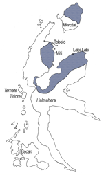
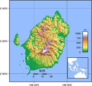
Halmahera, formerly known as Jilolo, Gilolo, or Jailolo, is the largest island in the Maluku Islands. It is part of the North Maluku province of Indonesia and Sofifi, the capital of the province, is located on the west coast of the island.
Patani is a coastal region in North Maluku, Indonesia, located on the eastern peninsula of Halmahera. Tepeleo is the biggest town in the area which is located within the Central Halmahera Regency. The area is perhaps most well-known for its high-quality nutmeg, although cocoa, copra, palm oil and coconut crab are known to be produced in the region.

Halmahera Sea is a regional sea located in the central eastern part of the Australasian Mediterranean Sea. It is centered at about 1°S and 129°E and is bordered by the Pacific Ocean to the north, Halmahera to the west, Waigeo and West Papua to the east, and the Seram Sea to the south. It covers about 95,000 km (59,000 mi) and its topography comprises a number of separate basins and ridges, the chief of which is the Halmahera Basin reaching a depth of 2039 m.
Tobelo is a North Halmahera language spoken on the eastern Indonesian island of Halmahera and on parts of several neighboring islands. The Tobelo-speaking heartland is in the district of Tobelo, located on the western shore of Kao Bay. The district capital, also known as Tobelo, serves as a regional commercial and administrative center and is the largest settlement on Halmahera.

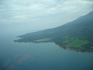
Tobelo is a town and a district on the eastern Indonesian island of Halmahera. It is the capital of the regency (kabupaten) of North Halmahera, part of the province of North Maluku. The city was formalised as the capital of North Halmahera in the district elections held in 2004. It has a population of approximately 33,700. A palm tree lined coastal road connects Tobelo to Galela. The town is predominantly Christian and a Protestant Church has existed in Tobelo since at least 1924.

Aketajawe-Lolobata National Park is a national park on Halmahera, the biggest island in the North Maluku province of Indonesia. The park is considered by BirdLife International to be vital for the survival of at least 23 endemic bird species. Aketajawe-Lolobata, which has an area of 167,300 hectares, was declared a national park in 2004.

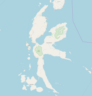
North Halmahera Regency is a regency of North Maluku Province, Indonesia. It was declared a Regency on 31 May 2003. The capital town of the regency lies at the port of Tobelo. The Regency, which has been considerably reduced by the separation of Tidore and of Morotai Island, now covers an area of 3,896.9 square kilometres (1,504.6 sq mi) and had a population of 161,847 people at the 2010 Census and 179,783 at the 2015 Intermediate Census. The latest official estimate is 199,935. The principal settlements are Tobelo, Kao and Galela. The area is noted for its white beaches and coral reefs.

Galela, is a small town on the eastern Indonesian island of Halmahera. It is located in the North Halmahera Regency, part of the province of North Maluku. Views of Mount Tarakani can be seen from the scenic coast. Galelarese constitutes an official ethnic group in North Halmhera and is also a language, spoken in the Galela region, neighboring parts of Tobelo and Loloda districts, on the island of Morotai and in villages scattered in southern Halmahera as well as on Bacan and Obi. The town borders Lake Galela.
Soasiu is a small coastal town on the eastern Indonesian island of Halmahera. It is located in the North Halmahera Regency, part of the province of North Maluku, and lies on the northwestern coast. A market is held in Soasiu every Tuesday and Friday. The Sonyine Malige Sultan's Museum is located in the outskirts of the town.

Jailolo is a town and former sultanate on Halmahera in Indonesia's Maluku Islands. It is located on the island's west coast approximately 20 km north of Ternate. Jailolo is a small port that serves Halmahera's northwestern coastal villages.
Morotai Island is an island in the Halmahera group of eastern Indonesia's Maluku Islands (Moluccas). It is one of Indonesia's northernmost islands.
Pagu, named after one of its dialects, is a North Halmahera language of Indonesia. Kao dialect is divergent.
Modole is a North Halmahera language of Indonesia. The language is spoken in several villages in the Kao region on the northern peninsula of the island of Halmahera.

The Togutil people are an indigenous group with a semi-nomadic lifestyle living in the jungles of Totodoku, Tukur-Tukur, Lolobata, Kobekulo and Buli, North Maluku in the Aketajawe-Lolobata National Park, North Halmahera Regency, North Maluku, Indonesia.
Kuabang Airport, also known as Kao Airport, is an airport located near Jati Village, serving the coastal town of Kao, North Halmahera Regency, North Maluku, Indonesia. The airport has a runway size of 1,950 by 45 metres, which can accommodate Narrow-body aircraft such as the Boeing 737 Classic. The distance from the airport to Tobelo is about 75 kilometres (47 mi) and takes about 2 hours using land vehicle. The airport currently only serves daily domestic flights to Manado operated by Wings Air using the ATR-72 aircraft.

Tobelo people is one of the northern Halmahera peoples living in eastern Indonesia, in the northern part of the Maluku Islands and in the eastern side of North Halmahera Regency.

The 2019 North Maluku earthquake, a shallow 7.2 magnitude earthquake, struck the island of Halmahera, North Maluku, Indonesia on 14 July 2019 at 18:10 local time with its epicentre located at South Halmahera. It struck at a shallow depth of 10 km (6.2 mi) near Labuha, a small port town located in Bacan Island. The earthquake produced a non-destructive 20 cm tsunami, which stuck Labuha just minutes after the shaking started. 14 people were killed by the earthquake while 129 people were injured, and more than 50,000 people were displaced. The earthquake inflicted a total damage of Rp 238 billion.
