
Elektrėnai Municipality is one of sixty municipalities in Lithuania.
Powałki is a PKP railway station in Powałki, Poland.
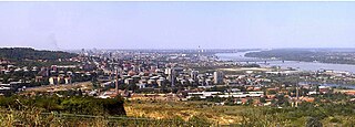
Lešće is an urban neighborhood of Belgrade, the capital of Serbia and one of city's largest cemeteries.
Yeröö is a sum (district) of Selenge Province in northern Mongolia. Bugant urban-type settlement is 66 km SE from Yeröö sum center.
Lepsze is a village in the administrative district of Gmina Zakrzewo, within Aleksandrów County, Kuyavian-Pomeranian Voivodeship, in north-central Poland.

Bartoszewice is a village in the administrative district of Gmina Płużnica, within Wąbrzeźno County, Kuyavian-Pomeranian Voivodeship, in north-central Poland. It lies approximately 3 kilometres (2 mi) south-east of Płużnica, 10 km (6 mi) west of Wąbrzeźno, and 31 km (19 mi) north-east of Toruń.

The Bremen Ratskeller is the council wine cellar of the Townhall of Bremen. Since it was erected in the year 1405, German wines were stored and sold there. With its history over 600 years the Ratskeller of Bremen is one of the oldest wine cellars of Germany, furthermore the oldest wine barrel of Germany, a wine from Rüdesheim which is dated 1653, is stored here.
Poredy-Leśniczówka is a village in the administrative district of Gmina Zbójna, within Łomża County, Podlaskie Voivodeship, in north-eastern Poland.
Ivarstown is a small village in County Clare, Munster in Ireland. The village covered a total area of 13 acres (53,000 m2) and was located within the parish of Kilfinaghta, in the baronry of Lower Bunratty. It takes its name from the Ievers family and is located on the opposite bank of the O'Garney river from the village of Sixmilebridge.
Krzywe Koło-Kolonia is a settlement in the administrative district of Gmina Suchy Dąb, within Gdańsk County, Pomeranian Voivodeship, in northern Poland. It lies approximately 4 kilometres (2 mi) south-west of Suchy Dąb, 12 km (7 mi) south-east of Pruszcz Gdański, and 22 km (14 mi) south of the regional capital Gdańsk.
Połchówko is a village in the administrative district of Gmina Krokowa, within Puck County, Pomeranian Voivodeship, in northern Poland. It lies approximately 6 kilometres (4 mi) south-east of Krokowa, 13 km (8 mi) west of Puck, and 50 km (31 mi) north-west of the regional capital Gdańsk.
Janowo is a former village in the administrative district of Gmina Susz, within Iława County, Warmian-Masurian Voivodeship, in northern Poland. It lies approximately 10 kilometres (6 mi) north of Susz, 28 km (17 mi) north-west of Iława, and 77 km (48 mi) west of the regional capital Olsztyn.
Bochlin is a village in the administrative district of Gmina Nowogard, within Goleniów County, West Pomeranian Voivodeship, in north-western Poland. It lies approximately 10 kilometres (6 mi) north-west of Nowogard, 27 km (17 mi) north-east of Goleniów, and 48 km (30 mi) north-east of the regional capital Szczecin.
Popielewice is a settlement in the administrative district of Gmina Połczyn-Zdrój, within Świdwin County, West Pomeranian Voivodeship, in north-western Poland.

Card Place is an unincorporated community in Mendocino County, California. It lies at an elevation of 823 feet. Card Place is located at 39°48′29″N123°24′17″W.

Puding County is a county in the west-central part of Guizhou province, China. It is under the administration of Anshun City.

Đipi is a village in the municipality of Višegrad, Bosnia and Herzegovina.

Jhunir, sometimes spelled Jhuner, is a town in the Sardulgarh tehsil of Mansa district in Punjab, India. It is also a block of the district.

Harlesiel is a resort town on the East Frisian coast of Germany, at the mouth of the Harle River. It lies in the Wittmund district, about 1 kilometre (0.62 mi) north of Carolinensiel. It is a small town, with a population of 809 in 2009, swelled by some 4800 tourists in season.

Fincastle is an unincorporated community in Franklin Township, Putnam County, in the U.S. state of Indiana.


