
Manitoba is a province of Canada at the longitudinal centre of the country. It is Canada's fifth-most populous province, with a population of 1,342,153 as of 2021. Manitoba has a widely varied landscape, from arctic tundra and the Hudson Bay coastline in the north to dense boreal forest, large freshwater lakes, and prairie grassland in the central and southern regions.
The Rural Municipality of Lakeview was a rural municipality (RM) in the Canadian province of Manitoba.
Ethelbert is an unincorporated urban community in the Municipality of Ethelbert, Manitoba, Canada.

St. Ambroise Beach is a 46-hectare (110-acre) provincial park on the shore of Lake Manitoba in the Rural Municipality of Portage la Prairie of Canada. Established in 1961, the park lies in the Lake Manitoba Plain Ecoregion and is surrounded by marshland, which provides a habitat for waterfowl. The park is open to the public for recreational activities and birding. Piping plovers nest on the beach and warblers, geese and pelicans pass through the park during migration season. A boardwalk with a viewing tower extends into the marsh. St. Ambroise Beach is a stop on the international Pine to Prairie birding trail, which runs from Minnesota through Manitoba.

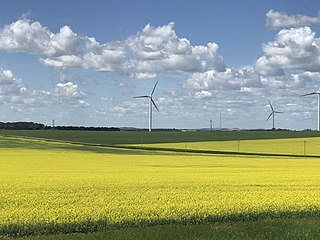
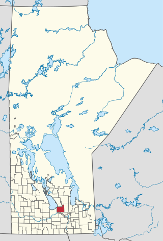
Census Division No. 8 is a census division located within the Central Plains Region of the Province of Manitoba, Canada. Unlike in some other provinces, census divisions do not reflect the organization of local government in Manitoba. These areas exist solely for the purposes of statistical analysis and presentation; they have no government of their own.
The Rural Municipality of Lansdowne is a former rural municipality (RM) in the Canadian province of Manitoba. It was originally incorporated as a rural municipality on December 22, 1883. It ceased on January 1, 2015 as a result of its provincially mandated amalgamation with the RM of Glenella to form the Municipality of Glenella – Lansdowne.
The Rural Municipality of Lorne is a former rural municipality (RM) in the Canadian province of Manitoba. It was originally incorporated as a rural municipality on February 14, 1880. It ceased on January 1, 2015 as a result of its provincially mandated amalgamation with the Village of Notre Dame de Lourdes and the Village of Somerset to form the Municipality of Lorne.
The Rural Municipality of Siglunes is a former rural municipality (RM) in the Canadian province of Manitoba. It was originally incorporated as a rural municipality on April 1, 1919. It ceased on January 1, 2015, as a result of its provincially mandated amalgamation with the RM of Eriksdale to form the Municipality of West Interlake.
Woodlands is a rural municipality (RM) in the province of Manitoba in Western Canada. It lies in the southern part of the Interlake and is named for the community of Woodlands, which itself is named for the wooded lands of the area.
The Municipality of Shoal Lake is a former rural municipality (RM) in the Canadian province of Manitoba. It was originally incorporated as a rural municipality on January 1, 2011. It ceased on January 1, 2015, as a result of its provincially mandated amalgamation with the RM of Strathclair to form the Rural Municipality of Yellowhead.
Manitoba Provincial Highway 68 is an east-west provincial highway in the central region of Manitoba, Canada.

The Rural Municipality of Prairie Lakes is a rural municipality (RM) in the Canadian province of Manitoba. The Rural Municipality of Prairies lakes surrounds most of the north end of Pelican Lake. There are several other lakes in the RM such as Grass Lake, Overend Lake, Bone Lake, Lorne Lake, Louise Lake, Lloyds Lake, Noble Lake and many more that are all much smaller than Pelican Lake.
Clearwater Lake Provincial Park was designated a provincial park by the Government of Manitoba in 1963. The park is 593 square kilometres (229 sq mi) in size. The park is considered to be a Class II protected area under the IUCN protected area management categories.
Baralzon Lake Ecological Reserve is an ecological reserve in the area surrounding the portion of Baralzon Lake within Manitoba, Canada. It was established in 1989 under the Manitoba Ecological Reserves Act. It is 396 square kilometres (153 sq mi) in size.
Lake St. George Caves Ecological Reserve is an ecological reserve located west of Lake Winnipeg, Manitoba, Canada. It was established in 1997 under the Manitoba Ecological Reserves Act. It is .49 square kilometres (0.19 sq mi) in size.
Lake Winnipegosis Salt Flats Ecological Reserve is an ecological reserve located on the west of Lake Winnipegosis, Manitoba, Canada. It was established in 1992 under the Manitoba Ecological Reserves Act. It is 47.25 square kilometres (18.24 sq mi) in size.
Pocock Lake Ecological Reserve is an ecological reserve located within the Sandilands Provincial Forest, Manitoba, Canada. It was established in 1997 under the Manitoba Ecological Reserves Act. It is 2.05 square kilometres (0.79 sq mi) in size.
Whitemouth Island Ecological Reserve is an ecological reserve which is the largest island of Whitemouth Lake in Manitoba. It was established in 1999 under the Manitoba Ecological Reserves Act. It is 6.13 square kilometres (2.37 sq mi) in size. The island is the most western example of a largely undisturbed deciduous forest of the St. Lawrence - Great Lakes region in Canada. It contains eight examples of eastern deciduous plants that are considered rare in Manitoba such as Dutchman's Breeches, green adder's mouth, blue cohosh, New Jersey tea, and enchanter's nightshade.

