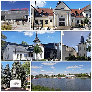
Grodzisk Mazowiecki is a town in central Poland, the capital of Grodzisk Mazowiecki County in the Masovian Voivodeship, with 29,363 inhabitants (2011). It is 30 kilometres (19 mi) southwest of Warsaw.
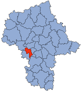
Grodzisk County is a unit of territorial administration and local government (powiat) in Masovian Voivodeship, east-central Poland. It came into being on 1 January 1999, as a result of the Polish local government reforms passed in 1998. Its administrative seat and largest town is Grodzisk Mazowiecki, which lies 29 kilometres (18 mi) south-west of Warsaw. The county also contains the towns of Milanówek, lying 2 km (1 mi) north-east of Grodzisk Mazowiecki, and Podkowa Leśna, 8 km (5 mi) east of Grodzisk Mazowiecki.
Gmina Grodzisk Mazowiecki is an urban-rural gmina in Grodzisk Mazowiecki County, Masovian Voivodeship, in east-central Poland. Its seat is the town of Grodzisk Mazowiecki, which lies approximately 29 kilometres (18 mi) south-west of Warsaw.

Adamowizna is a village in the administrative district of Gmina Grodzisk Mazowiecki, within Grodzisk Mazowiecki County, Masovian Voivodeship, in east-central Poland. It lies approximately 5 kilometres (3 mi) south of Grodzisk Mazowiecki and 30 km (19 mi) south-west of Warsaw.
Chlebnia is a village in the administrative district of Gmina Grodzisk Mazowiecki, within Grodzisk Mazowiecki County, Masovian Voivodeship, in east-central Poland. It lies approximately 5 kilometres (3 mi) north-west of Grodzisk Mazowiecki and 31 km (19 mi) west of Warsaw.

Chrzanów Duży is a village in the administrative district of Gmina Grodzisk Mazowiecki, within Grodzisk Mazowiecki County, Masovian Voivodeship, in east-central Poland. It lies approximately 3 kilometres (2 mi) north of Grodzisk Mazowiecki and 28 km (17 mi) west of Warsaw.

Chrzanów Mały is a village in the administrative district of Gmina Grodzisk Mazowiecki, within Grodzisk Mazowiecki County, Masovian Voivodeship, in east-central Poland. It lies approximately 5 kilometres (3 mi) north of Grodzisk Mazowiecki and 27 km (17 mi) west of Warsaw.

Kozerki is a village in the administrative district of Gmina Grodzisk Mazowiecki, within Grodzisk Mazowiecki County, Masovian Voivodeship, in east-central Poland. It lies approximately 2 kilometres (1 mi) south-west of Grodzisk Mazowiecki and 31 km (19 mi) south-west of Warsaw.
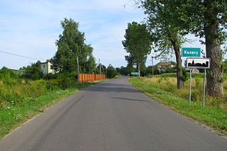
Kozery is a village in the administrative district of Gmina Grodzisk Mazowiecki, within Grodzisk Mazowiecki County, Masovian Voivodeship, in east-central Poland. It lies approximately 4 kilometres (2 mi) west of Grodzisk Mazowiecki and 32 km (20 mi) west of Warsaw.

Kraśnicza Wola is a village in the administrative district of Gmina Grodzisk Mazowiecki, within Grodzisk Mazowiecki County, Masovian Voivodeship, in east-central Poland. It lies approximately 5 kilometres (3 mi) west of Grodzisk Mazowiecki and 32 km (20 mi) west of Warsaw.

Książenice is a village in the administrative district of Gmina Grodzisk Mazowiecki, within Grodzisk Mazowiecki County, Masovian Voivodeship, in east-central Poland. It lies approximately 7 kilometres (4 mi) south-east of Grodzisk Mazowiecki and 27 km (17 mi) south-west of Warsaw.

Makówka is a village in the administrative district of Gmina Grodzisk Mazowiecki, within Grodzisk Mazowiecki County, Masovian Voivodeship, in east-central Poland. It lies approximately 7 kilometres (4 mi) south of Grodzisk Mazowiecki and 33 km (21 mi) south-west of Warsaw.

Mościska is a village in the administrative district of Gmina Grodzisk Mazowiecki, within Grodzisk Mazowiecki County, Masovian Voivodeship, in east-central Poland. It lies approximately 5 kilometres (3 mi) south of Grodzisk Mazowiecki and 32 km (20 mi) south-west of Warsaw.

Natolin is a village in the administrative district of Gmina Grodzisk Mazowiecki, within Grodzisk Mazowiecki County, Masovian Voivodeship, in east-central Poland. It lies approximately 3 kilometres (2 mi) north of Grodzisk Mazowiecki and 28 km (17 mi) west of Warsaw.
Nowe Kłudno is a village in the administrative district of Gmina Grodzisk Mazowiecki, within Grodzisk Mazowiecki County, Masovian Voivodeship, in east-central Poland.

Nowe Kozery is a village in the administrative district of Gmina Grodzisk Mazowiecki, within Grodzisk Mazowiecki County, Masovian Voivodeship, in east-central Poland. It lies approximately 3 kilometres (2 mi) west of Grodzisk Mazowiecki and 32 km (20 mi) south-west of Warsaw.

Radonie is a village in the administrative district of Gmina Grodzisk Mazowiecki, within Grodzisk Mazowiecki County, Masovian Voivodeship, in east-central Poland. It lies approximately 6 kilometres (4 mi) south of Grodzisk Mazowiecki and 30 km (19 mi) south-west of Warsaw.

Szczęsne is a village in the administrative district of Gmina Grodzisk Mazowiecki, within Grodzisk Mazowiecki County, Masovian Voivodeship, in east-central Poland.

Tłuste is a village in the administrative district of Gmina Grodzisk Mazowiecki, within Grodzisk Mazowiecki County, Masovian Voivodeship, in east-central Poland. It lies approximately 5 kilometres (3 mi) north of Grodzisk Mazowiecki and 28 km (17 mi) west of Warsaw.

Zabłotnia is a village in the administrative district of Gmina Grodzisk Mazowiecki, within Grodzisk Mazowiecki County, Masovian Voivodeship, in east-central Poland. It lies approximately 5 kilometres (3 mi) north-west of Grodzisk Mazowiecki and 31 km (19 mi) west of Warsaw.


