
Year 1061 (MLXI) was a common year starting on Monday of the Julian calendar.
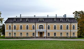
Kehtna is a small borough in Rapla County, in central Estonia, located about 9 km (6 mi) southeast of the town of Rapla. Other nearby settlements include Keava, Kaerepere and Lelle. Kehtna is the administrative centre of Kehtna Parish. It has a population of 1,674.

The Narva, formerly also Narwa or Narova, flows 77 kilometres (48 mi) north into the Baltic Sea and is the largest Estonian river by discharge. A similar length of land far to the south, together with it and a much longer intermediate lake, Lake Peipus, all together nowadays form the international border between Estonia and Russia.

Jäneda is a small village in northern Estonia. It is located in Lääne-Viru County and is a part of Tapa municipality.
Ugaunians or Ugannians, referred to as Chudes by the earliest Russian chronicles, were a historic Finnic people inhabiting the southern Estonian Ugandi County that is now Tartu, Põlva, Võru and Valga counties of Estonia.

Ugandi was an independent county between the east coast of Lake Võrtsjärv and west coast of Lake Pskov, bordered by Vaiga, Mõhu, Nurmekund, Sakala, Tālava, and The Principality of Pskov. Ugandi had an area of approximately 3000 hides. Ugandi corresponded roughly to the present Estonia's territory of Võru County, Põlva County and half of Tartu County and Valga County, as well as Petseri County.

Chanctonbury Ring is a prehistoric hill fort atop Chanctonbury Hill on the South Downs, on the border of the civil parishes of Washington and Wiston in the English county of West Sussex. A ridgeway, now part of the South Downs Way, runs along the hill. It forms part of an ensemble of associated historical features created over a span of more than 2,000 years, including round barrows dating from the Bronze Age to the Saxon periods and dykes dating from the Iron Age and Roman periods.

Cave Hill or Cavehill is a rocky hill overlooking the city of Belfast, Northern Ireland,with a height of 368 metres (1,207 ft). It is marked by basalt cliffs and caves, and its distinguishing feature is 'Napoleon's Nose', a tall cliff resembling the profile of the emperor Napoleon. On top of this are the remains of an ancient promontory fort called McArt's Fort. Cavehill was also historically called 'Ben Madigan', after a king of Ulster called Madagán.

Railways with a railway track gauge of 5 ft first appeared in the United Kingdom and the United States. This gauge became commonly known as "Russian gauge", because the government of the Russian Empire chose it in 1843. Former areas and states of the Empire have inherited this standard. However in 1970, Soviet Railways re-defined the gauge as 1,520 mm.
Sakala County was an ancient Estonian county that was first mentioned in print by Henry of Latvia in the early 13th century.

Chitradurga Fort, or as the British called it Chitaldoorg, is a fortification that straddles several hills and a peak overlooking a flat valley in the Chitradurga District, Karnataka, India. The fort's name Chitrakaldurga, which means 'picturesque fort' in Kannada, is the namesake of the town Chitradurga and its administrative district.

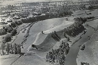
The Varbola Stronghold was the largest circular rampart fortress and trading centre built in Estonia, in Harju County in the 10th – 12th centuries. Parts of the ruins of the 580-metre (1,900 ft) long and 8-to-10-metre high limestone wall of the fortress stand to this day. The long gateways with multiple gates were built to defend the entrances. In these sections higher defensive towers were erected. There was a 13-metre (43 ft) deep well in the middle of the fortress and the territory held about 90 structures with furnaces for accommodation built with limestone floors and foundations.

Agra Fort railway station, is located near Agra Fort, in Rawatpara, Agra. It used to be one of the stations in India that had both broad gauge and metre gauge, until the line to Jaipur was converted to broad gauge. Agra Fort railway station comes under the North Central Railways.
This is a timeline of Estonian history, comprising important legal and territorial changes and political events in Estonia and its predecessor states. To read about the background to these events, see History of Estonia. See also the list of rulers of Estonia.

Hunsbury Hill is an Iron Age hill fort two miles (3 km) south-west of the centre of the town of Northampton in the county of Northamptonshire.

Rohuneeme is a village in Viimsi Parish, Harju County in northern Estonia. It is located about 14 km (9 mi) northeast of the centre of Tallinn, situated on the northern end of the Viimsi Peninsula. As of the 2011 census, the settlement's population was 440.

Konuvere is a village in Märjamaa Parish, Rapla County in western Estonia, on the north side of the Konuvere River.
The Viking Age in Estonia was a period in the history of Estonia, part of the Viking Age. It was not a unified country at the time, and the area of Ancient Estonia was divided among loosely allied regions. It was preceded by the Bronze and Early Iron Ages in Estonia, during which an agrarian society had developed, the Migration Period, and Pre-Viking Age with the Viking Age itself lasting between 800 and 1050 AD. It is often considered to be part of the Iron Age period which started around 400 AD and ended around 1200 AD. Some 16th-century Swedish chronicles attribute the Pillage of Sigtuna in 1187 to Estonian raiders.

The Vigala is a 96.7 km (60.1 mi)-long river in Rapla County, Estonia. It is a tributary of the Kasari River. Its source is in the Keava Bog. The basin area of the Vigala is 1,577 km2 (609 sq mi).

Thundersbarrow Hill is an archaeological site in West Sussex, England. It is on a chalk ridge, aligned north-west to south-east, on the South Downs north of Shoreham-by-Sea.


