Narva is a municipality and city in Estonia. It is located in the Ida-Viru County, at the eastern extreme point of Estonia, on the west bank of the Narva river which forms the Estonia–Russia international border. With 53,626 inhabitants Narva is Estonia's third largest city after capital Tallinn and Tartu.
Saue is a town in north-western Estonia. It's the administrative centre of Saue Parish in Harju County.

Valga is a town in southern Estonia and the capital of Valga County and Valga Parish. Until their separation in 1920, Valga and the town of Valka in northern Latvia were one town. They are now twin-towns. The area of Valga is 16.5 square kilometres and that of Valka is 14.2 km2 (5.5 sq mi). Their populations are respectively 12,261 and 6,164. On 21 December 2007 all border-crossing points were removed and roads and fences opened between the two countries with both countries joining the Schengen Agreement.

Otto August Strandman was an Estonian politician, who served as prime minister (1919) and State Elder of Estonia (1929–1931). He was one of the leaders of the centre-left Estonian Labour Party, that saw its biggest support after the 1919 and 1920 elections. Strandman was a key figure in composing the radical land reform law and the 1920 Constitution. He also served as Minister of Agriculture (1918–1919), Minister of Justice, Minister of Finance (1924), Minister of Foreign Affairs and Minister of War (1919). While he was holding the office of the Minister of Finance, he stabilized the economy and managed to avoid hyperinflation. Strandman served as the speaker of the Estonian Provincial Assembly in 1917–1918, and as speaker of the newly independent country's parliament (Riigikogu) in 1921. He was also a diplomat, serving as the Estonian envoy in Warsaw, Poland (1927–1929), and in Paris, France (1933–1939).

Harju County, is one of the fifteen counties of Estonia. It is situated in Northern Estonia, on the southern coast of the Gulf of Finland, and borders Lääne-Viru County to the east, Järva County to the southeast, Rapla County to the south, and Lääne County to the southwest. The capital and largest city of Estonia, Tallinn, is situated in Harju County. Harju County is the largest county in Estonia in terms of population, as almost half (45%) of the Estonia's population lives in Harju County.

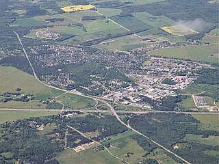
Tapa is a town in Tapa Parish, Lääne-Viru County, Estonia, located at the junction of the country's Tallinn–Narva (west–east) and Tallinn–Tartu–Valga (north–south) railway lines.It is an important centre of transit for freight as well as rail passengers, a home to soldiers since the 1930s. Tapa also plays an important role in training young men and women in the Estonian Defense Forces, being nearby to Keskpolügoon. The Valgejõgi River passes Tapa on its northeastern side.

Rakvere is a town in northern Estonia and the administrative centre of the Lääne-Viru maakond (county), 20 km south of the Gulf of Finland of the Baltic Sea. Rakvere is the 8th most populous urban area in Estonia. Rakvere has a total area of 10.75 square kilometres, and although about 15% of Rakvere is covered by forest, it is still the country's third most densely populated urban area. From the 13th century until the early 20th century, Rakvere was more widely known by its historical German name, Wesenberg(h).

Kadrina Parish is a rural municipality in Lääne-Viru County, northern Estonia. It covers an area of 329.26 km² and has a population of 5,156. The parish has had its current borders since 2005, when Saksi Parish was dissolved and Kiku, Pariisi and Salda villages were merged to Kadrina Parish, the larger part of Saksi Parish was added to Tapa Parish.

Keila is a town and an urban municipality in Harju County in north-western Estonia, 25 km (16 mi) southwest of Tallinn. Keila is also the location of administrative buildings of the surrounding Keila Parish, a rural municipality separate from the town itself.

Kilingi-Nõmme is a town in Pärnu County, southwestern Estonia. It is the administrative centre of Saarde Parish. It's located on the intersection of Valga–Uulu and Tartu–Viljandi–Kilingi-Nõmme roads, about 11 km (7 mi) from the Estonian border with Latvia.

The rail transport system in Estonia consists of about 1,200 kilometres (750 mi) of railway lines, of which 900 kilometres (560 mi) are currently in public use. The infrastructure of the railway network is mostly owned by the state and is regulated and surveyed by the Estonian Technical Surveillance Authority.

Raasiku is a borough in Raasiku Parish, Harju County, Estonia, with a population of 1,372 (2020). Although situated in a parish with the same name, Raasiku is not the official administrative centre of the municipality. The settlement started to grow in the 19th century around the railway station. The Raasiku manor was established on the grounds of the earlier Kaemla (Keamol) village and in the middle ages it belonged to Padise Abbey.
Tamsalu is a town in Tapa Parish, Lääne-Viru County, Estonia.
Revel Governorate, also known as Tallinn Governorate, was an administrative division of the Russian Empire from 1719 to 1783.
Haabneeme is a small borough in Viimsi Parish, Harju County, in northern Estonia alongside Viimsi. It's located about 9 km (6 mi) northeast of the centre of Tallinn, on the eastern coast of Tallinn Bay. With a population of 5,634, Haabneeme is the largest settlement in the municipality.

Haljala is a small borough in Lääne-Viru County, in northern Estonia. It's located about 10 km northwest of the town of Rakvere, by the Tallinn–Narva road. Haljala is the administrative centre of Haljala Parish. As of the 2011 Census, the settlement's population was 1,084.
Aasuvälja is a village in Vinni Parish, Lääne-Viru County, in northeastern Estonia. Prior to the 2017 administrative reform of Estonian local governments, the village was located in Rägavere Parish.

Viru-Kabala is a village in Vinni Parish, Lääne-Viru County, in northeastern Estonia. It is located by the Tallinn–Narva railway, 18 km east of Rakvere and 9 km west of Sonda. The village has a population of 113. Prior to the 2017 administrative reform of Estonian local governments, the village was located in Rägavere Parish.

Imastu is a village in Tapa Parish, Lääne-Viru County, in northern Estonia. It is located about 2.5 km (2 mi) east of the town of Tapa. Imastu is bordered by the Pärnu–Rakvere road to the southeast, the Tallinn–Tapa–Narva railway to the northwest and the Valgejõgi River to the southwest.

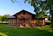
Moe is a village in Tapa Parish, Lääne-Viru County, in northern Estonia. It's located about 3.5 km southeast of the town of Tapa, on the Valgejõgi River. Moe is passed by the Pärnu–Rakvere road, and is bordered by the Tallinn–Tapa–Tartu railway to the southwest. As of 2011 Census, the settlement's population was 206.