Menteng is a district in the administrative city of Central Jakarta, Indonesia. Menteng is surrounded by the districts of Senen and Matraman to the east, Tebet and Setiabudi to the south, Tanah Abang to the west, and Gambir to the north. Menteng is bound by the West Flood Canal to the west, Ciliwung River to the south and east, and Kebon Sirih Road to the north. Menteng is the district seat of the Central Jakarta government.
Gambir is a district in the administrative city of Central Jakarta, Indonesia.. It is characterized by many historic buildings from the colonial era. It hosts some of the foremost political and learning/tourism features of the capital. The Merdeka Palace, the National Museum, the headquarters of the Indonesian Scout Movement and the Merdeka Square are among these.

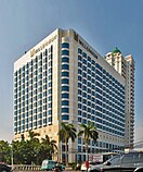
Jalan Jaksa is a short street approximately 400 meters long at Menteng subdistrict in Central Jakarta, Indonesia. It is located about 1 km south of the national museum, Monas and west of the Gondangdia railway station. The street connects Jalan KH Wahid Hasyim to Jalan Kebon Sirih. The six-meter-wide road offers tourists the opportunity to get cheap accommodation, and used to be a hub for nightlife, however, for several years now the nightlife scene here has dwindled with tourists and locals gravitating towards newer areas. It was designed as the main choice of foreign as well as domestic backpackers who visited Jakarta until around 2016.

Sawah Besar is a district (kecamatan) of Central Jakarta, Indonesia. Its neighborhoods are among the most historic, containing the 1820-established Pasar Baru, the new colonial city – Weltevreden – and the old course of the Ciliwung river. Landmarks include the Lapangan Banteng, the government's 19th century-built, low-rise A.A. Maramis Building and its high palmed-lawned vista, and Jakarta Cathedral.

Senen is a long-established urban district of Central Jakarta, Indonesia that has kept many tourist attractions such as two museums, the National Library of Indonesia, Gelanggang Remaja Senen, and narrow alleys with old Chinese and similar style shops and restaurants. It was first developed in the 18th century as Pasar Senen when Governor Daendels established the bovenstad as the new center of government of the fledgling city. Its core remains in what is now the lower-division Senen Ditrict, Kwitang, Kenari, Paseban, Kramat, and Bungur. Senen is bounded by a railway line to the east, Ciliwung River to the west, Pramuka Street to the south, and Abdul Rahman Saleh-Kwini II-Senen Raya IV Street to the north. The name is derived from Pasar Senen,.
Makasar is a district (kecamatan) of East Jakarta, Indonesia. It had an area of 21.85 km2 and population of 185,830 at the 2010 Census; the latest official estimate is 204,595.

Kebayoran Baru is a district in the administrative city of South Jakarta, Indonesia. The name was derived from a planned satellite city of the same name which was developed in the post-war period. Kebayoran Baru was the last residential area to be developed by the Dutch colonial administration. The urban planning was laid in a concept of the Garden city movement, consisting of a well-planned residential area, a shopping center, and a business district, supported with civic facilities such as schools, places of worship, hospitals, and parks. Today, the district is home to many important government institutions, such as the Indonesia Stock Exchange building, the ASEAN Headquarters building, the National Police headquarters, and the City Hall of South Jakarta. Sudirman Central Business District is also located in the district.
Tebet is a district in the administrative city of South Jakarta, Indonesia. The boundaries of Tebet are Jend. Gatot Subroto-Letjen Haryono MT. tollway to the south, Ciliwung River to the east, Jalan Casablanca - Ciliwung River to the north, and Cideng River to the west. This district is home to SMA Negeri 8 Jakarta

Abdul Wahid Hasyim was the first Minister of Religious Affairs in the government of President Sukarno of Indonesia, a post he held in 1945, and from 1949 to 1952.
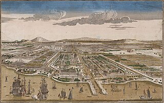
Jakarta is Indonesia's capital and largest city. Located on an estuary of the Ciliwung River, on the northwestern part of Java, the area has long sustained human settlement. Historical evidence from Jakarta dates back to the 4th century CE, when it was a Hindu settlement and port. The city has been sequentially claimed by the Indianized kingdom of Tarumanegara, the Hindu Kingdom of Sunda, the Muslim Sultanate of Banten, and by Dutch, Japanese and Indonesian administrations. The Dutch East Indies built up the area before it was taken during World War II by the Empire of Japan and finally became independent as part of Indonesia.
Kwitang is an administrative village (kelurahan) in the subdistrict (kecamatan) of Senen, Central Jakarta. It is one of the historic administrative village of Jakarta. The boundary of Kwitang is the Ciliwung to the west, Jalan Kramat Kwitang to the north, Jalan Kramat Raya to the east, and Jalan Kramat 4 to the south.
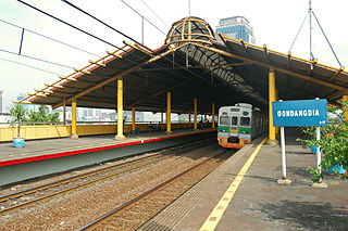
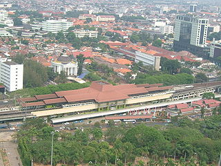
Gondangdia Station (GDD) is a railway station serving by Jakarta Commuterline at Gondangdia, Menteng, Central Jakarta, Indonesia.

Jalan M.H. Thamrin or Jalan Thamrin is a major thoroughfare in Jakarta, Indonesia. The road is located at the center of Jakarta, running from the north end of Jalan Jenderal Sudirman at West Flood Canal at the south end to the roundabout near Arjuna Wijaya Statue Jakarta at the north end. Developed in the 1950s, the road was a landmark of post-colonial Indonesia and continues to have a prominent importance in Jakarta.
All Saints Anglican Church, Jakarta, also known as All Saints Jakarta, is an Anglican church located in Kebon Sirih Administrative Village, Menteng, Jakarta. It is the only Anglican parish in Indonesia but there are over 30 other Anglican churches throughout Indonesia. The church is located in Jalan Arief Rahman Hakim, close to the Farmer's Statue. It is among the oldest church in Indonesia and was built in 1832. The church of All Saints Anglican Church Jakarta contains memorials to British soldiers who fell during World War I and World War II, as well as earlier memorials e.g. Lieutenant Colonel William Campbell .
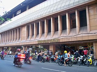
Cikini Station is a railway station located on Jl. Cikini Raya, Cikini, Menteng, Jakarta. This station is only served by KRL Commuterline commuter trains from Jakarta Kota to Depok and Bogor.

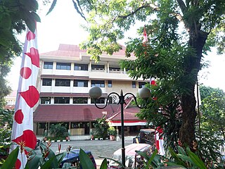
Jakarta City Hall is the seat of the Jakarta City government. The complex contains the official office of the governor and the vice governor of Jakarta, and the main administrative office. Jakarta City Hall is located south of Merdeka Square.

Jalan Jenderal Gatot Subroto(Gatot Subroto Avenue) is one of the major roads in Jakarta, Indonesia. The road starts from Dirgantara statue in South Jakarta, which crosses 10 administrative villages and ends at Slipi, Central Jakarta. The road is named after National Hero of Indonesia General Gatot Subroto. The road was constructed in 1960s. The road runs parallel with Jakarta Inner Ring Road. The location of the road is within the Golden Triangle CBD of Jakarta. Many important office buildings and skyscrapers are situated along the road.
The Golden Triangle of Jakarta or can also be referred to as Medan Merdeka–Thamrin–Sudirman Axis or Sudirman–Thamrin–Kuningan Axis, is a roughly triangular area in the center of Jakarta, Indonesia, extending from Central Jakarta to South Jakarta. Most of the city's tallest skyscrapers, office buildings and foreign embassies are located in the area, which is the main CBD of Jakarta.

Jalan Daan Mogot is one of the main avenues in Jakarta, Indonesia. The road is named after a military officer involved in the struggle for Indonesian independence Daan Mogot. This road stretches along 27.5 KM from Grogol, West Jakarta to Sukarasa, Tangerang, Tangerang. After entering Tangerang, this road continues to Jalan Merdeka and Jalan Gatot Subroto .This road is part of Indonesian National Route 1. This road crosses 14 urban villages, namely