Kebroyd | |
---|---|
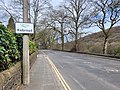
![]() Kebroyd view from Halifax Road | |
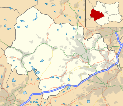
Location within West Yorkshire | |
OS grid reference | SE 04363 21094 |
Civil parish | |
Metropolitan borough | |
Metropolitan county | |
Region | |
Country | England |
Sovereign state | United Kingdom |
Post town | Sowerby Bridge |
Dialling code | 01422 |
Police | West Yorkshire |
Fire | West Yorkshire |
Ambulance | Yorkshire |
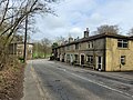
Kebroyd is a small hamlet in the civil parish of Ripponden, in the Calderdale district, in West Yorkshire, England, within the valley of the River Ryburn, between Sowerby Bridge and Ripponden. Kebroyd has an approximate population of 548 people as per the UK 2011 census (Output Area E00055242 [1] and E00055241). [2]
The name Kebroyd is believed to have derived from the Old English words "keb" and "royd", keb meaning "shelter for lambs" or "old sheep", [3] and "royd" meaning clearing. [4] The hamlet has a rich history, with evidence of human settlement dating back to the Iron Age. [5]
During the Industrial Revolution, Calderdale became a hub for textile manufacturing, with several mills being established in the area including Kebroyd Silk Mills. [6]
There are several Grade II listed buildings dating to the 17th century in Kebroyd, including Kebroyd Hall, Denton House and the row of Mill cottages on Halifax Road. [7] [8]
West Yorkshire is a ceremonial county in the Yorkshire and the Humber region of England. It borders North Yorkshire to the north and east, South Yorkshire and Derbyshire to the south, Greater Manchester to the south-west, and Lancashire to the west. The city of Leeds is the largest settlement.
Brighouse is a town within the metropolitan borough of Calderdale, in West Yorkshire, England. Historically within the West Riding of Yorkshire, it is situated on the River Calder, 4 miles (6.4 km) east of Halifax. It is served by Junction 25 of the M62 motorway and Brighouse railway station on the Caldervale Line and Huddersfield Line. In the town centre is a mooring basin on the Calder and Hebble Navigation. The United Kingdom Census 2001 gave the Brighouse / Rastrick subdivision of the West Yorkshire Urban Area a population of 32,360. The Brighouse ward of Calderdale Council gave a population of 11,195 at the 2011 Census. Brighouse has a HD6 postcode.
Elland is a market town in Calderdale, in the county of West Yorkshire, England. It is situated south of Halifax, by the River Calder and the Calder and Hebble Navigation. Elland was recorded as Elant in the Domesday Book of 1086. It had a population in 2001 of 14,554, with the ward being measured at 11,676 in the 2011 Census.
Mytholmroyd is a large village and former civil parish, now in the parish of Hebden Royd, in the Calderdale district, in West Yorkshire, England, 2 miles (3 km) east of Hebden Bridge. It lies in the Upper Calder Valley, 10 miles (16 km) east of Burnley and 7 miles (11 km) west of Halifax. The village, which has a population of approximately 4,000 is in the Luddendenfoot Ward of Calderdale Council.
Ripponden is a village and civil parish on the River Ryburn near Halifax in West Yorkshire, England. Historically it was part of the West Riding of Yorkshire. Its population was 6,412 at the time of the 2001 Census, and 7,421 in 2011.
Copley is a village in the metropolitan borough of Calderdale, in the county of West Yorkshire, England, south of Halifax and east of Sowerby Bridge. It is situated by the River Calder and the Calder and Hebble Navigation canal.
Sowerby Bridge is a market town in the Upper Calder Valley in Calderdale in West Yorkshire, England. The Calderdale Council ward population at the 2011 census was 11,703.
Calderdale is a metropolitan borough of West Yorkshire, England, which had a population of 211,439. It takes its name from the River Calder, and dale, a word for valley. The name Calderdale usually refers to the borough through which the upper river flows, while the actual landform is known as the Calder Valley. Several small valleys contain tributaries of the River Calder. The main towns of the borough are Brighouse, Elland, Halifax, Hebden Bridge, Sowerby Bridge and Todmorden.
Cragg Vale is a village in Calderdale, West Yorkshire, England, located south of Mytholmroyd on the B6138 road which joins the A58 and the A646. The village is part of Luddendenfoot Ward of Calderdale Council.
The Calder Valley line is a railway route in Northern England between the cities of Leeds and Manchester as well as the seaside resort of Blackpool. It is the slower of the two main rail routes between Leeds and Manchester, and the northernmost of the three main trans-Pennine routes.
The River Ryburn is a river in West Yorkshire, England. It flows through the villages of Rishworth, Ripponden and Triangle before flowing into the River Calder at Sowerby Bridge.
Sowerby Bridge railway station serves the town of Sowerby Bridge in West Yorkshire, England. It lies on the Caldervale Line 4.5 miles (7 km) west of Halifax and 21 miles (34 km) west of Leeds.
Hebden Royd is a civil parish in the Metropolitan Borough of Calderdale in West Yorkshire, England. According to the 2001 census it had a population of 9,092, rising to 9,558 at the 2011 census. It includes market town of Hebden Bridge and the villages of Mytholmroyd and Cragg Vale. The parish was an urban district before 1974, created in 1937 by the merger of Hebden Bridge and Mytholmroyd urban districts.
Soyland is a village in Calderdale, West Yorkshire, England. It is just north of Ripponden off the A58 road and is 5 miles (8 km) south west of Halifax. It is part of Ripponden civil parish. The village referred to as Soyland Town, used to be the site of several textile mills, but these have closed down. The walking route Calderdale Way passes through the area.
Barkisland is a village in Calderdale, West Yorkshire, England. Historically part of the West Riding of Yorkshire, it is 1 mile (1.6 km) east of Ripponden, 2 miles (3.2 km) south of Sowerby Bridge and 4 miles (6.4 km) south-west of Halifax town centre.
The Rishworth branch was built in the Ryburn valley by the Lancashire and Yorkshire Railway and linked Sowerby Bridge with Rishworth and served the villages of Triangle, Ripponden, Barkisland and Rishworth.
Ryburn Reservoir is a supply reservoir operated by Yorkshire Water close to Ripponden in the Yorkshire Pennines, England. It lies in the valley of the River Ryburn and is the lower of two reservoirs built in the valley to supply Wakefield with water and was completed in 1933. The upper reservoir is Baitings Reservoir.
Rishworth is a village in Calderdale, West Yorkshire, England. Historically in the West Riding of Yorkshire, it has a small church, farms and schools, including Rishworth School. In 1931 the parish had a population of 838.
Calderdale Metropolitan Borough Council is the local authority for the Metropolitan Borough of Calderdale in West Yorkshire, England. The council styles itself Calderdale Council. It is a metropolitan district council, one of five in West Yorkshire and one of 36 in the metropolitan counties of England. It provides the majority of local government services in Calderdale. Since 2014 the council has been a constituent member of the West Yorkshire Combined Authority.