Kelloholm

Last updated

Kelloholm
Kelloholm and Kirkconnel from the air - geograph.org.uk - 5613698.jpg
Aerial view
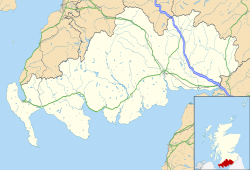
Dumfries and Galloway UK location map.svg
Red pog.svg
Kelloholm
Location within Dumfries and Galloway
OS grid reference NS737116
Council area
Lieutenancy area
Country Scotland
Sovereign state United Kingdom
Post town SANQUHAR
Postcode district DG4
Dialling code 01659
Police Scotland
Fire Scottish
Ambulance Scottish
UK Parliament
Scottish Parliament
List of places
UK
Scotland
55°22′56″N3°59′42″W / 55.3821°N 3.995°W / 55.3821; -3.995

Kelloholm is a village in Dumfries and Galloway, Scotland. It has a primary school, [1] a public house and several shops. Kelloholm lies next to Kirkconnel and the two have begun to merge. Kelloholm was originally constructed to serve the many mines in the area, all of which have now closed.
Contents

History

Kelloholm gets its name from the Kello Water and the village began to appear in the early 20th century.

Governance

Kelloholm is part of the Dumfriesshire, Clydesdale and Tweeddale (UK Parliament constituency) and is represented by the Conservative Party MP David Mundell.

Transport

The A76 road runs through the area. Kelloholm is served by bus routes 221 and 246. [2]

The area is served by Kirkconnel railway station on the Glasgow South Western Line.

Notable people

Related Research Articles

<span class="mw-page-title-main">Dumfries</span> Town in Dumfries and Galloway, Scotland

Dumfries is a market town and former royal burgh in Dumfries and Galloway, Scotland, near the mouth of the River Nith on the Solway Firth, 25 miles (40 km) from the Anglo-Scottish border. Dumfries is the county town of the historic county of Dumfriesshire.

<span class="mw-page-title-main">Dumfries and Galloway</span> Council area of Scotland

Dumfries and Galloway is one of the 32 unitary council areas of Scotland, located in the western part of the Southern Uplands. It is bordered by East Ayrshire, South Ayrshire, and South Lanarkshire to the north; Scottish Borders to the north-east; the English ceremonial county of Cumbria, the Solway Firth, and the Irish Sea to the south, and the North Channel to the west. The administrative centre and largest settlement is the town of Dumfries. The second largest town is Stranraer, located 76 miles (122 km) to the west of Dumfries on the North Channel coast.

<span class="mw-page-title-main">Sanquhar</span> Human settlement in Scotland

Sanquhar is a village on the River Nith in Dumfries and Galloway, Scotland, north of Thornhill and west of Moffat. It is a former Royal Burgh.

<span class="mw-page-title-main">Thornhill, Dumfries and Galloway</span> Village in rural lowland Scotland

Thornhill is a village in the Mid Nithsdale area of Dumfries and Galloway, Scotland, south of Sanquhar and north of Dumfries on the main A76 road. Thornhill sits in the Nithsdale valley with the Carsphairn and Scaur range to the west and the Lowther hills to the east. It was initially a small village, planned and built in 1717 on the Queensberry Estate on the road linking Dumfries to Glasgow. The Earl of Queensberry initially named the village 'New Dalgarnock' however the name did not achieve popular approval.

<span class="mw-page-title-main">Ayr</span> Administrative centre and town in Scotland

Ayr is a town situated on the southwest coast of Scotland. A former royal burgh, today it is the administrative centre of the South Ayrshire Council, and the historic county town of Ayrshire. With a population of 46,982, Ayr is the 15th largest settlement in Scotland and second largest town in Ayrshire by population. The town is contiguous with the smaller town of Prestwick to the north.

<span class="mw-page-title-main">Kirkcaldy</span> Town and former royal burgh in Scotland

Kirkcaldy is a town and former royal burgh in Fife, on the east coast of Scotland. It is about 11.6 miles (19 km) north of Edinburgh and 27.6 miles (44 km) south-southwest of Dundee. The town had a recorded population of 49,460 in 2011, making it Fife's second-largest settlement and the 11th most populous settlement in Scotland.

<span class="mw-page-title-main">Dumfriesshire</span> Historic county in Scotland

Dumfriesshire or the County of Dumfries or Shire of Dumfries is a historic county and registration county in southern Scotland. The Dumfries lieutenancy area covers a similar area to the historic county.

<span class="mw-page-title-main">Houston, Renfrewshire</span> Human settlement in Scotland

Houston, is a village in the council area of Renfrewshire and the larger historic county of the same name in the west central Lowlands of Scotland.

Leven is a seaside town in Fife, set in the east Central Lowlands of Scotland. It lies on the coast of the Firth of Forth at the mouth of the River Leven, 8.1 miles (13.0 km) north-east of the town of Kirkcaldy and 6.4 miles (10.3 km) east of Glenrothes.

<span class="mw-page-title-main">Kirkconnel</span> Human settlement in Scotland

Kirkconnel is a small parish in Dumfries and Galloway, southwestern Scotland. It is located on the A76 near the head of Nithsdale. Principally it has been a sporting community. The name comes from The Church of Saint Conal. In 1850 the village had only a single street. Next to Kirkconnel is a separate village called Kelloholm.

<span class="mw-page-title-main">Galloway and Upper Nithsdale (UK Parliament constituency)</span> Parliamentary constituency in the United Kingdom, 1983–2005

Galloway and Upper Nithsdale was a county constituency which returned one Member of Parliament (MP) to the House of Commons of the Parliament of the United Kingdom, elected by the first past the post voting system.

<span class="mw-page-title-main">Thornliebank</span> Human settlement in Scotland

Thornliebank is a suburban area in East Renfrewshire, in the west central Lowlands of Scotland. Part of the Greater Glasgow conurbation, it is located on the Auldhouse Burn about six miles south of Glasgow city centre, and just outside the city's administrative boundaries. The neighbouring East Renfrewshire town of Giffnock lies directly to the east, with Rouken Glen Park to the south.

<span class="mw-page-title-main">St Mary's Cathedral, Edinburgh (Episcopal)</span> Cathedral in Edinburgh, Scotland

The Cathedral Church of Saint Mary the Virgin, commonly known as St Mary's Episcopal Cathedral, is a cathedral of the Scottish Episcopal Church in the West End of Edinburgh, Scotland; part of the worldwide Anglican Communion.

<span class="mw-page-title-main">The Canongate</span> A district of Edinburgh, the capital city of Scotland.

The Canongate is a street and associated district in central Edinburgh, the capital city of Scotland. The street forms the main eastern length of the Royal Mile while the district is the main eastern section of Edinburgh's Old Town.

<span class="mw-page-title-main">Richard Scott, 10th Duke of Buccleuch</span> Scottish nobleman, b. 1954

Richard Walter John Montagu Douglas Scott, 10th Duke of Buccleuch and 12th Duke of Queensberry,, styled as Lord Eskdaill until 1973 and as Earl of Dalkeith from 1973 until 2007, is a Scottish landholder and peer. He is the Duke of Buccleuch and Queensberry, as well as Chief of Clan Scott. He is a descendant of James, Duke of Monmouth, the eldest illegitimate son of Charles II and his mistress, Lucy Walter, and more remotely in a direct male line from Alan of Dol, who arrived in Britain in 1066 with William the Conqueror.

<span class="mw-page-title-main">Old Town, Edinburgh</span> The oldest part of Edinburgh

The Old Town is the name popularly given to the oldest part of Scotland's capital city of Edinburgh. The area has preserved much of its medieval street plan and many Reformation-era buildings. Together with the 18th/19th-century New Town, and West End, it forms part of a protected UNESCO World Heritage Site.

<span class="mw-page-title-main">Lockerbie</span> Town in Scotland

Lockerbie is a town in Dumfries and Galloway, south-western Scotland. It is about 120 km (75 mi) from Glasgow, and 25 km (16 mi) from the border with England. The 2001 Census recorded its population as 4,009. The town came to international attention in December 1988 when the wreckage of Pan Am Flight 103 crashed there following a terrorist bomb attack aboard the flight.

<span class="mw-page-title-main">Copford</span> Village and civil parish in Essex, England

Copford is a village and civil parish in the City of Colchester district of Essex, England. It is 3 kilometres (2 mi) west of Colchester, and the hamlet of Copford Green is found a short distance to the south. The poet Matthew Arnold noted he was struck by "the deeply rural character of the village and neighbourhood."

<span class="mw-page-title-main">Carsphairn and Scaur Hills</span> Hills in Scotland

The Carsphairn and Scaur Hills are the western and eastern hills respectively of a hill range in the Southern Uplands of Scotland. Ordnance Survey maps don't have a general name for the hill area as a whole. Also, Ordnance Survey use "Scar" rather than the local spelling of "Scaur" - the word is pronounced as "Scar" however. In their Landranger Series of maps, it requires four separate sheets to cover the area.

References

  1. "Kelloholm School". Kelloholm School. Education Scotland. Archived from the original on 20 April 2012. Retrieved 29 December 2011.
  2. "Kirkconnel, Main St, Queensberry (On Main Street)". Kirkconnel, Main St, Queensberry (On Main Street). transport direct. Retrieved 29 December 2011.[ permanent dead link ]