
Kennington is a district in south London, England. It is mainly within the London Borough of Lambeth, running along the boundary with the London Borough of Southwark, a boundary which can be discerned from the early medieval period between the Lambeth and St George's parishes of those boroughs respectively. It is located 1.4 miles (2.3 km) south of Charing Cross in Inner London and is identified as a local centre in the London Plan. It was a royal manor in the parish of St Mary, Lambeth in the county of Surrey and was the administrative centre of the parish from 1853. Proximity to central London was key to the development of the area as a residential suburb and it was incorporated into the metropolitan area of London in 1855.

Newington is a district of South London, just south of the River Thames, and part of the London Borough of Southwark. It was an ancient parish and the site of the early administration of the county of Surrey. It was the location of the County of London Sessions House from 1917, in a building now occupied by the Inner London Crown Court.

Stockwell is a district in South West London, England, located in the London Borough of Lambeth. It is situated 2.4 miles (3.9 km) south of Charing Cross. Battersea, Brixton, Clapham, South Lambeth, Oval and Kennington all border Stockwell.

Vauxhall is a district of South London, England. Vauxhall was part of Surrey until 1889 when the County of London was created.

Wandsworth is a London borough in southwest London; it forms part of Inner London and has an estimated population of 329,677 inhabitants. Its main settlements are Battersea, Putney, Tooting and Wandsworth Town.

Lambeth is a London borough in South London, England, which forms part of Inner London. Its name was recorded in 1062 as Lambehitha and in 1255 as Lambeth. The geographical centre of London is at Frazier Street near Lambeth North tube station, though nearby Charing Cross on the other side of the Thames in the City of Westminster is traditionally considered the centre of London.

The London Inner Ring Road, or Ring Road as signposted, is a 12-mile (19 km) route with an average diameter of 2.75–5.5 miles (4.43–8.85 km) formed from a number of major roads that encircle Central London. The ring road forms the boundary of the London congestion charge zone, although the ring road itself is not part of the zone.

Lambeth is a district in South London, England, in the London Borough of Lambeth, historically in the County of Surrey. It is situated 1 mile (1.6 km) south of Charing Cross. The population of the London Borough of Lambeth was 303,086 in 2011. The area experienced some slight growth in the medieval period as part of the manor of Lambeth Palace. By the Victorian era the area had seen significant development as London expanded, with dense industrial, commercial and residential buildings located adjacent to one another. The changes brought by World War II altered much of the fabric of Lambeth. Subsequent development in the late 20th and early 21st centuries has seen an increase in the number of high-rise buildings. The area is home to the International Maritime Organization.

Lambeth Palace is the official London residence of the Archbishop of Canterbury. It is situated in north Lambeth, London, on the south bank of the River Thames, 400 yards south-east of the Palace of Westminster, which houses the Houses of Parliament, on the opposite bank.

Lambeth was a civil parish and metropolitan borough in south London, England. It was an ancient parish in the county of Surrey. The parish was included in the area of responsibility of the Metropolitan Board of Works in 1855 and became part of the County of London in 1889. The parish of Lambeth became a metropolitan borough in 1900, following the London Government Act 1899, with the parish vestry replaced by a borough council.

Oval is an area in south London, in the London Borough of Lambeth. It is the part of Kennington near The Oval cricket ground, situated 2.1 miles (3.38 km) to the south-east of Charing Cross. Oval straddles the border of south-west London and south-east London, and is where the postcode SE11 converges with the postcodes SW8 and SW9.

Westminster Bridge Road is a road in London, England. It runs on an east–west axis and passes through the boroughs of Lambeth and Southwark.

Kennington Road is a long straight road, approximately a mile in length, in the London Borough of Lambeth in London, England, running south from Westminster Bridge Road to Kennington Park Road.
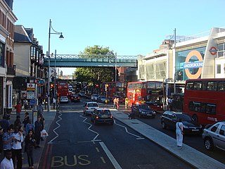
Brixton Road is a road in the London Borough of Lambeth, leading from the Oval at Kennington to Brixton, where it forms the high street and then forks into Effra Road and Brixton Hill at St Matthew's church at the junction with Acre Lane and Coldharbour Lane. Brixton Market is located in Electric Avenue near Brixton Underground station and in a network of covered arcades adjacent to the two railway viaducts. The market arcades were declared listed buildings in 2009 following controversial proposals by Lambeth Council to replace them with a large US-style mall. The former "Brixton Oval" is at the southern end with Lambeth Town Hall, the Ritzy Cinema, the Brixton Tate Library and St Matthew's church. The space was renamed Windrush Square in 2010, in honour of the area's early Caribbean migrants and the HMT Empire Windrush, which in 1948 brought 492 passengers from Jamaica to London.

The A202 is a primary A road in London. It runs from New Cross Gate to London Victoria station. A section of the route forms a part of the London Inner Ring Road between Vauxhall and Victoria, known as Vauxhall Bridge Road.
Vauxhall bus station is a bus station in Vauxhall, in the London Borough of Lambeth. It is operated by London Buses and owned and maintained by Transport for London, and is the second busiest bus station in the city.

Vassall ward is an administrative division of the London Borough of Lambeth, United Kingdom. It is also known as 'Myatt's Field' when informally describing the area. It is located in the North of borough bordering Southwark, in the SW9 and SE5 postcode area. The area is named after Henry Vassall-Fox, 3rd Baron Holland who was responsible for the first building development in the area in the 1820s.

St Matthew’s Church is a Church of England church in the London Borough of Lambeth. It is a Grade II* listed building which occupies a prominent position at the junction of Brixton Road, Brixton Hill and Effra Road. The church was constructed following the Church Building Act 1818 and was consecrated in 1824.

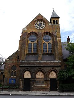
St Anselm's Church is a Grade II listed church at 286 Kennington Road, Kennington, London SE11, built in 1932–33 by Stanley Davenport Adshead and Stanley Churchill Ramsey, on the foundations of an earlier church whose building was interrupted by the First World War; the present church is famously described as "barn-like".
St Peter's, Vauxhall, is a Church of England church on Kennington Lane, Vauxhall, London SE11.

