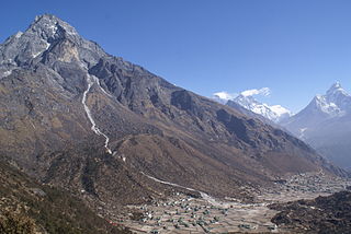
Khumjung is a village in Khumbu Pasanglhamu rural municipality of Solukhumbu District in Province No. 1 of north-eastern Nepal. It is located in the Khumbu subregion inside Sagarmatha National Park, a world heritage site. The village is at an elevation of 3,790 metres above sea level, and is situated near Mount Khumbila.

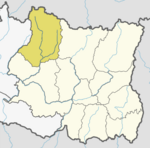
Mahakulung is a rural municipality (gaunpalika) out of seven rural municipality located in Solukhumbu District of Province No. 1 of Nepal. There are a total of 8 municipalities in Solukhumbu in which 1 is urban and 7 are rural.

Solududhkunda (earlier:Dudhkunda) is the only municipality of Solukhumbu District. Located in Province No. 1 of Nepal. The town of Salleri, which is located within the municipality is the headquarter of Solukhumbu District It was formed in 2014 by merging four VDCs: Salleri, Garma, Loding Tamakhani and Beni and was divided into 9 wards. Total area of the municipality had 254.3 square kilometres (98.2 sq mi) and population of municipality had 20,399 individuals living in 5,368 households.

Baku is a village development committee (VDC) in Solukhumbu District in the Sagarmatha Zone of north-eastern Nepal. Baku lies in the Himalaya, 59 km South of Mount Everest and is bordered by the valleys of Dudh Kosi River (West) and Hinku Drangka River (East). At the time of the 1991 Nepal census it had a population of 4159 people living in 777 individual households. At the 2011 census, the population of the VDC Baku was 4844 inhabitants in 963 individual households.
Basa, Nepal is a village development committee in Solukhumbu District in the Sagarmatha Zone of north-eastern Nepal. At the time of the 1991 Nepal census it had a population of 3256.
Bung is a village development committee in Solukhumbu District in the Sagarmatha Zone of north-eastern Nepal. At the time of the 1991 Nepal census it had a population of 3368 people living in 737 individual households. At the 2011 census, the population of Bung was 4520 inhabitants in 982 individual households. Bung lies in the Himalaya mountains, 54 km South of Mount Everest and is bordered by the Hunku Drangka (East). Gudel lies on the other side of the valley of Bung.
Tingla is a village development committee in Solukhumbu District in the Sagarmatha Zone of north-eastern Nepal. At the time of the 1991 Nepal census it had a population of 3,738 people living in 710 individual households.
Chaurikharka is a village development committee in Solukhumbu District in the Sagarmatha Zone of northeastern Nepal. At the time of the 1991 Nepal census it had a population of 2422 people living in 502 individual households.
Deusa is a village development committee in Solukhumbu District in the Sagarmatha Zone of north-eastern Nepal. At the time of the 1991 Nepal census it had a population of 3835 people living in 747 individual households.
Goli is a village development committee in Solukhumbu District in the Sagarmatha Zone of north-eastern Nepal. At the time of the 1991 Nepal census it had a population of 2276 people living in 455 individual households.
Kaku, Nepal is a village development committee in Solukhumbu District in the Sagarmatha Zone of north-eastern Nepal. At the time of the 1991 Nepal census it had a population of 3896 people living in 750 individual households.
Kangel is a village development committee in Solukhumbu District in the Sagarmatha Zone of north-eastern Nepal. At the time of the 1991 Nepal census it had a population of 2087 people living in 416 individual households.
Necha Batase is a village development committee in Solukhumbu District in the Sagarmatha Zone of north-eastern Nepal. At the time of the 1991 Nepal census it had a population of 3522 people living in 680 individual households.

Salyan, Solukhumbu is a village development committee in Solukhumbu District in the Sagarmatha Zone of north-eastern Nepal. At the time of the 1991 Nepal census it had a population of 5307 people living in 1034 individual households. It has been merged into Necha Salyan Gaupalika.
Tapting is a village development committee in Solukhumbu District in the Sagarmatha Zone of north-eastern Nepal. At the time of the 1991 Nepal census it had a population of 2016 people living in 339 individual households. According to recent population research data in 2015,the population of Tapting VDC is 7580,living in 4850 individual households. Transportation--> = High Way Road is Connected from Capital Kathmandu to Tapting VDC.

Dudhkaushika is a rural municipality (gaunpalika) out of seven rural municipality located in Solukhumbu District of Province No. 1 of Nepal. There are a total of 8 municipalities in Solukhumbu in which 1 is urban and 7 are rural.
Nechasalyan is a rural municipality (gaunpalika) out of seven rural municipality located in Solukhumbu District of Province No. 1 of Nepal. There are a total of 8 municipalities in Solukhumbu in which 1 is urban and 7 are rural.
Dudhkoshi is a rural municipality (gaunpalika) out of seven rural municipality located in Solukhumbu District of Province No. 1 of Nepal. There are a total of 8 municipalities in Solukhumbu in which 1 is urban and 7 are rural.
Likhu Pike is a rural municipality (gaunpalika) out of seven rural municipality located in Solukhumbu District of Province No. 1 of Nepal. There are a total of 8 municipalities in Solukhumbu in which 1 is urban and 7 are rural.