Rangeli is a Municipality and rural market town in Morang District in the Koshi Zone of south-eastern Nepal. This municipality was formed merging existing four villages i.e.Amgachhi, Babiabirta, Darbesa and Rangeli itself since May 2014.
The 1991 Nepal census was a widespread national census conducted by the Nepal Central Bureau of Statistics.
Batakachaur is a village development committee in Baglung District in the Dhaulagiri Zone of central Nepal. At the time of the 1991 Nepal census it had a population of 4,142 and had 794 houses in the village.
Kulau is a village development committee in Baitadi District in the Mahakali Zone of western Nepal. At the time of the 1991 Nepal census it had a population of 3,376 and had 378 houses in the town.

Bageshwari is a town in Banke District in the Bheri Zone of south-western Nepal. At the time of the 1991 Nepal census it had a population of 9,740 and had 1711 houses in the town.
Kavresthali is a town and former Village Development Committee that is now part of Tarakeshwar Municipality in Kathmandu District in Province No. 3 of central Nepal. At the time of the 1991 Nepal census it had a population of 3034 and had 581 households in it.
Naubasta is a town in Banke District in the Bheri Zone of south-western Nepal. At the time of the 1991 Nepal census it had a population of 11,160 and had 1663 houses in the town.
Asrang is a village development committee in Gorkha District in the Gandaki Zone of northern-central Nepal. At the time of the 1991 Nepal census it had a population of 3,241 and had 604 houses in the town.
Bhumlichok is a village development committee in Gorkha District in the Gandaki Zone of northern-central Nepal. At the time of the 1991 Nepal census it had a population of 2,964 and had 518 houses in the town.
Darbhung is a village development committee in Gorkha District in the Gandaki Zone of northern-central Nepal. At the time of the 68 Nepal census it had a population of 15005 and had 3900 houses in the town.
Phujel is a town in Gorkha District in the Gandaki Zone of northern-central Nepal. At the time of the 1991 Nepal census it had a population of 4,563 and had 841 houses in the town.
Gakhu is a village development committee in Gorkha District in the Gandaki Zone of northern-central Nepal. At the time of the 1991 Nepal census it had a population of 2,870 and had 572 houses in the town.
Ghyalchok is a village in Gorkha District in the Gandaki Province of northern-central Nepal. At the time of the 1991 Nepal census it had a population of 4,659 and had 848 houses in the town.
Khoplang is a village development committee in Gorkha District in the Gandaki Zone of northern-central Nepal. At the time of the 1991 Nepal census it had a population of 5,227 and had 1054 houses in the town. Former Prime Minister of Nepal Baburam Bhattarai was born here.
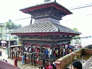
Manakamana is a village development committee in Gorkha District in the Gandaki Zone of northern-central Nepal. At the time of the 1991 Nepal census it had a population of 5,083 and had 889 houses in the town.
Kalati Bhumidanda is a town and municipality in Kabhrepalanchok District in the Bagmati Zone of central Nepal. At the time of the 1991 Nepal census it had a population of 3801.
Machchhegaun is a town and municipality in Kathmandu District in the Bagmati Zone of central Nepal. At the time of the 1991 Nepal census it had a population of 5951 in 979 individual households.
Khalanga is a town and the district headquarters of the Darchula District in the Sudurpashchim Pradesh province of Nepal. It is part of the Mahakali Municipality in the Mahakali Zone. The town is located on the bank of Mahakali River and the border with Uttarakhand state, India. The town on the Indian side of the border also has similar name, spelt as Dharchula.
Shivanagar is a town in Krishnanagar Municipality in Kapilvastu District in the Lumbini Zone of southern Nepal. The former VDC was merged to form the municipality established on 18 May 2014 Krishnanagar, Sirsihawa, Shivanagar VDCs. At the time of the 2011 Nepal census it had a population of 4,774 people living in 735 individual households.
Bhagwanpur is a rural municipality in Siraha District in Province No. 2 of south-eastern Nepal. At the time of the 2011 Nepal census it had a population of 20957 people living. It is located nearly 370 kilometers or 107 miles east of the capital, Kathmandu.