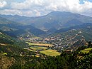
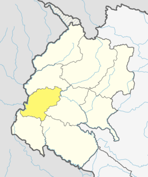
Arghakhanchi is one of the districts of Lumbini Province in Nepal. The district headquarter is Sandhikharka. The district covers an area of 1,193 km2 (461 sq mi) and has a population (2011) of 197,632. Its neighboring districts are Palpa in the east, Gulmi in the north, Kapilvastu District in the south and Pyuthan in the west.

Hinduism is the main and largest religion of Nepal. The Constitution of Nepal has established a call for the protection of this age-old religion mostly referring to Indic religion throughout the country. In 2007, the country declared itself a secular country; still, some special privileges were given to Hinduism. According to the 2011 census, the Hindu population in Nepal is estimated to be around 21,551,492, which accounts for at least 81.34% of the country's population, the highest percentage of Hindus of any country in the world. The national calendar of Nepal, Vikram Samvat, is a solar Hindu calendar essentially the same to that widespread in North India as a religious calendar, and is based on Hindu units of time. Nepal remained the last Hindu country in the world until 2008, after the abolition of monarchy in the nation.

|langs = Sunuwar, Nepali |rels = Predominantly Kiranti, Buddhism

Bardiya District, one of the seventy-seven Districts of Nepal, is part of Lumbini Province of Nepal. The district, with Gulariya as its headquarters, covers an area of 2,025 km2 (782 sq mi) and according to the 2001 census the population was 382,649 in 2011 it has 426,576.
Dadeldhura district, a part of Sudurpashchim Province, is one of the seventy-seven districts of Nepal. The district, with Dadeldhura as its district headquarters, covers an area of 1,538 km2 (594 sq mi) and had a population of 126,162 in 2001 and 142,094 in 2011.

Kathmandu District is a district located in Kathmandu Valley, Bagmati Province of Nepal. It is one of the 77 districts of Nepal, covers an area of 413.69 km2 (159.73 sq mi), and is the most densely populated district of Nepal with 1,081,845 inhabitants in 2001 and 1,744,240 in 2011. The district's headquarter is Kathmandu Metropolitan City, also the capital of Nepal. It is also a famous tourist spot as there are many religious temples, attracting places.

Parsa District (Nepali: पर्सा जिल्लाListen , a part of Province No. 2 in Terai plain, is one of the seventy-seven districts of Nepal. The district, with Birgunj as its district headquarters, covers an area of 1,353 km2 and has a population of 497,219. According to the locals, Parsa is named after Parashnath temple situated in Mahuwan.
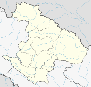
Ramechhap District, a part of Bagmati Province, is one of the seventy-seven districts of Nepal, a landlocked country of South Asia. The district, known as wallo Kirat Ramechhap, with Manthali as its district headquarters, covers an area of 1,546 km2 (597 sq mi) and has a population (2011) of 202,646 and a density of 137.4 per km2.

Lekhnath was a municipality in Kaski District in the Gandaki Province of northern-central Nepal, about 180 km west of Kathmandu. It has now been merged into Pokhara sub-metropolitan city to form Pokhara metropolis. Pokhara Valley was politically divided between Pokhara city and Lekhnath which occupied the eastern half of the valley. There were 18 wards in total in Lekhnath municipality before the merger, with a VDC Bharat Pokhari that had been added at a later stage.

Bhimphedi, is a village located in Makwanpur District of Bagmati Province of Nepal. This village is known for its bazaar (marketplace). Bismuth ore is mined here.

Nepalis are the citizens of Nepal under the provisions of Nepali nationality law. The country is home to people of many different national origins. As a result, people of Nepal do not equate their nationality with ethnicity and language, but with citizenship and allegiance. Although citizens make up the majority of the Nepalis, non-citizen residents, dual citizens, and expatriates may also claim a Nepali identity. Nepalis can also be descendants of migrants from Tibet, as well as parts of Myanmar and Yunnan, and may further trace their origin to Central Asia, along with indigenous peoples.

The 2011 National census lists 123 Nepalese languages spoken as a mother tongue in Nepal. The discovery of six additional languages since then brings the count to 129. Most belong to the Indo-Aryan and Sino-Tibetan language families.

A Village Development Committee (VDC) in Nepal was the lower administrative part of its Ministry of Federal Affairs and Local Development. Each district had several VDCs, similar to municipalities but with greater public-government interaction and administration. There were 3,157 village development committees in Nepal. Each VDC was further divided into several wards depending on the population of the district, the average being nine wards.
Patarasi is a rural municipality located in Jumla District of Karnali Province of Nepal.
Situated on the bank of Kaligandaki river, Khadgakot is a town and Village Development Committee, in Gulmi District in the Lumbini Zone of central Nepal. At the time of the 1991 Nepal census it had a population of 4297 persons living in 808 individual households.

Chulachuli is a rural municipality (gaunpalika) out of six rural municipality located in Ilam District of Province No. 1 of Nepal. There are a total of 10 municipalities in Ilam in which 4 are urban and 6 are rural.
Taruka was a village development committee in Nuwakot District in the Bagmati Zone of central Nepal. At the time of the 1991 Nepal census it had a population of 4845 people living in 912 individual households. Taruka is famous for its vegetable production and annual bullfight. The annual bullfight occurs on first day on tenth month of Nepali calendar.
Dullu is an urban Municipality in Dailekh District of Karnali Pradesh in Nepal.

Babare is a village in Kalinchowk Rural Municipality in Dolakha District in the Bagmati Province of north-eastern Nepal. At the time of the 1991 Nepal census it had a population of 3,392 people living in 739 individual households.

Sundar Haraicha is a municipality in Morang District of Province No. 1 in Nepal that was established on 10 March 2017 by merging the former municipalities Sundar Dulari and Koshi Haraicha. At the time of the 2011 Nepal census, the localities formed had a joint population of 80,518 people living in 18,610 individual households.