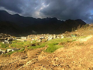
Rangeli is a Municipality and rural market town in Morang District in the Koshi Zone of south-eastern Nepal. This municipality was formed merging existing four villages i.e.Amgachhi, Babiabirta, Darbesa and Rangeli itself since May 2014.
The 1991 Nepal census was a widespread national census conducted by the Nepal Central Bureau of Statistics.

Adguri is a small town in Arghakhanchi District in Lumbini Province of southern Nepal. At the time of the 1991 Nepal census, the town had a population of 4174 living in 804 houses. At the time of the 2001 Nepal census, the population was 4409, of which 57% was literate.

Arghatosh is a small town in Arghakhanchi District in Lumbini Province of southern Nepal. At the time of the 1991 Nepal census, the town had a population of 4637 living in 887 houses. At the time of the 2001 Nepal census, the population was 4627, of which 61% was literate.

Balkot is a small town in Arghakhanchi District in Lumbini Province of southern Nepal. At the time of the 1991 Nepal census, the town had a population of 4283 living in 858 houses. At the time of the 2001 Nepal census, the population was 4532, of which 63% was literate.
Bhagavathi is a small town in Arghakhanchi District in the Lumbini Zone of southern Nepal. At the time of the 1991 Nepal census, the town had a population of 4418 living in 842 houses. At the time of the 2001 Nepal census, the population was 4543, of which 59% was literate.

Chidika is a small town in Arghakhanchi District in the Lumbini Zone of southern Nepal. At the time of the 1991 Nepal census, the town had a population of 3578 living in 697 houses. At the time of the 2001 Nepal census, the population was 3886, of which 50% was literate.

Dhakawang is a small town in Arghakhanchi District in the Lumbini Zone of southern Nepal. At the time of the 1991 Nepal census, the town had a population of 6229 living in 1165 houses. At the time of the 2001 Nepal census, the population was 7042, of which 53% was literate.

Dhanchour is a small town in Arghakhanchi District in the Lumbini Zone of southern Nepal. At the time of the 1991 Nepal census, the town had a population of 3529 living in 648 houses. At the time of the 2001 Nepal census, the population was 3992, of which 33% was literate.

Dharapani is a small town in Arghakhanchi District in the Lumbini Zone of southern Nepal. At the time of the 1991 Nepal census, the town had a population of 5236 living in 1020 houses. At the time of the 2001 Nepal census, the population was 6455, of which 65% was literate.

Dhikura is a small town in Arghakhanchi District in the Lumbini Zone of southern Nepal. At the time of the 1991 Nepal census, the town had a population of 3996 living in 728 houses. At the time of the 2001 Nepal census, the population was 4542, of which 62% was literate.
Hansapur is a small town in Arghakhanchi District in the Lumbini Zone of southern Nepal. At the time of the 1991 Nepal census, the town had a population of 7407 living in 1458 houses. At the time of the 2001 Nepal census, the population was 8103, of which 53% was literate.

Batakachaur is a village development committee in Baglung District in the Dhaulagiri Zone of central Nepal. At the time of the 1991 Nepal census it had a population of 4,142 and had 794 houses in the village.

Martadi is a town and seat of Bajura District Coordination Committee. It is also the headquarters of the Badi Malika Municipality. At the time of the 1991 Nepal census it had a population of 4,618 and had 942 houses in the town but now it has increased by growth rate of 2.62 and reached 8807.

Phujel is a town in Gorkha District in the Gandaki Zone of northern-central Nepal. At the time of the 1991 Nepal census it had a population of 4,563 and had 841 houses in the town.

Kalati Bhumidanda is a town and municipality in Kabhrepalanchok District in the Bagmati Zone of central Nepal. At the time of the 1991 Nepal census it had a population of 3801.

Machchhegaun is a town and municipality in Kathmandu District in the Bagmati Zone of central Nepal. At the time of the 1991 Nepal census it had a population of 5951 in 979 individual households.

Ruru is a town and municipality in Gulmi District in the Lumbini Zone of central Nepal. At the time of the 1991 Nepal census it had a population of 3628.

Khalanga is a town and the district headquarters of the Darchula District in the Sudurpashchim Pradesh province of Nepal. It is part of the Mahakali Municipality in the Mahakali Zone. The town is located on the bank of Mahakali River and the border with Uttarakhand state, India. The town on the Indian side of the border also has similar name, spelt as Dharchula.
The 2001 Nepal census was conducted by the Nepal Central Bureau of Statistics. According to the census, the population of Nepal in 2001 was 23,151,423. Working with Nepal's Village Development Committees at a district level, they recorded data from all the main towns and villages of each district of Nepal. The data included statistics on population size, households, sex and age distribution, place of birth, residence characteristics, literacy, marital status, religion, language spoken, caste/ethnic group, economically active population, education, number of children, employment status, and occupation.


