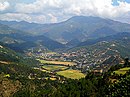
Dhankuta is a hill town and the headquarter of Koshi Zone located in Dhankuta District of Eastern Nepal. According to 2011 Nepal census, it has population of 26,440 inhabitants.

This article is about a city which is administered by municipality

Mahottari District, a part of Province No. 2, is one of the seventy-seven districts of Nepal. The district, with Jaleshwar as its district headquarters, covers an area of 1,002 km2 (387 sq mi) and had a population of 553,481 in 2001 and 627,580 in 2011. Its headquarters is located in Jaleshwar, a neighbouring town of the historical city of Janakpur. The name Jaleshwar means the 'God in Water'. One can find a famous temple of Lord Shiva in Water there. Jaleshwar lies at a few kilometres distance from the Nepal-India border and has a majority Maithili population. In Janakpur zone there are two districts ; mahottari and Dhanusha and both are in a distance of 1 hour.

Raxaul is a sub-divisional town in the East Champaran district of the Indian state of Bihar. It is situated on the India-Nepal border opposite Birgunj (Nepal). Raxaul is a major railway terminus.

Rangeli is a Municipality and rural market town in Morang District in the Koshi Zone of south-eastern Nepal. This municipality was formed merging existing four villages i.e.Amgachhi, Babiabirta, Darbesa and Rangeli itself since May 2014.

Triyuga is one of eight municipalities of Udayapur district of the Province No. 1 of Nepal. Gaighat is the headquarter of the municipality. According to the 1991 Nepal census, it had a population of 55,291. According to the 2011 Nepal census, Triyuga had 87,557 inhabitants. It is divided into 16 wards. Triyuga Municipality was established on B.S. Chaitra 13, 2053. It was named after Triyuga River. A river which flows through the town. Triyuga is the 3rd largest municipality in Nepal and 1st largest in Province No. 1 in term of size (area). The total area of the municipality is 547.43 square kilometres (211.36 sq mi)

Solududhkunda (earlier:Dudhkunda) is the only municipality of Solukhumbu District. Located in Province No. 1 of Nepal. The town of Salleri, which is located within the municipality is the headquarter of Solukhumbu District It was formed in 2014 by merging four VDCs: Salleri, Garma, Loding Tamakhani and Beni and was divided into 9 wards. Total area of the municipality had 254.3 square kilometres (98.2 sq mi) and population of municipality had 20,399 individuals living in 5,368 households.
The 1991 Nepal census was a widespread national census conducted by the Nepal Central Bureau of Statistics.
Bhagavathi is a small town in Arghakhanchi District in the Lumbini Zone of southern Nepal. At the time of the 1991 Nepal census, the town had a population of 4418 living in 842 houses. At the time of the 2001 Nepal census, the population was 4543, of which 59% was literate.
Batakachaur is a village development committee in Baglung District in the Dhaulagiri Zone of central Nepal. At the time of the 1991 Nepal census it had a population of 4,142 and had 794 houses in the village.

Naubasta is a town in Banke District in the Bheri Zone of south-western Nepal. At the time of the 1991 Nepal census it had a population of 11,160 and had 1663 houses in the town.
Phujel is a town in Gorkha District in the Gandaki Zone of northern-central Nepal. At the time of the 1991 Nepal census it had a population of 4,563 and had 841 houses in the town.
Phinam was a village development committee in Gorkha District in the Gandaki Zone of northern-central Nepal. It was merged into Gorkha Municipality in 2014. At the time of the 1991 Nepal census, it had a population of 2,993 and had 580 houses in the town.
Muchhok is a village development committee in Gorkha District in the Gandaki Zone of northern-central Nepal. At the time of the 1991 Nepal census it had a population of 3,663 and had 727 houses in the town.
Taklung is a village development committee in Gorkha District in the Gandaki Zone of northern-central Nepal. At the time of the 1991 Nepal census it had a population of 4,835 and had 859 houses in the town.
Kalati Bhumidanda is a town and municipality in Kabhrepalanchok District in the Bagmati Zone of central Nepal. At the time of the 1991 Nepal census it had a population of 3801.
Machchhegaun is a town and municipality in Kathmandu District in the Bagmati Zone of central Nepal. At the time of the 1991 Nepal census it had a population of 5951 in 979 individual households.
Khalanga is a town and the district headquarters of the Darchula District in the Sudurpashchim Pradesh province of Nepal. It is part of the Mahakali Municipality in the Mahakali Zone. The town is located on the bank of Mahakali River and the border with Uttarakhand state, India. The town on the Indian side of the border also has similar name, spelt as Dharchula.
Shivanagar is a town in Krishnanagar Municipality in Kapilvastu District in the Lumbini Zone of southern Nepal. The former VDC was merged to form the municipality established on 18 May 2014 Krishnanagar, Sirsihawa, Shivanagar VDCs. At the time of the 2011 Nepal census it had a population of 4,774 people living in 735 individual households.
Bhagwanpur is a rural municipality in Siraha District in Province No. 2 of south-eastern Nepal. At the time of the 2011 Nepal census it had a population of 20957 people living. It is located nearly 370 kilometers or 107 miles east of the capital, Kathmandu.