Hillsborough County is located in the west-central portion of the U.S. state of Florida. In the 2020 census, the population was 1,459,762, making it the fourth-most populous county in Florida and the most populous county outside the Miami metropolitan area. A 2021 estimate has the population of Hillsborough County at 1,512,070 people with a yearly growth rate of 1.34%, which itself is greater than the populations of 12 states according to their 2019 population estimates. Its county seat and largest city is Tampa. Hillsborough County is part of the Tampa–St. Petersburg–Clearwater Metropolitan Statistical Area.

Keystone is an unincorporated census-designated place in Hillsborough County, Florida, United States. The Keystone area was first settled in the middle 1800s by the W.M. Mobley Family who migrated from Savannah, Georgia. The region has evolved from citrus and farming into a rural retreat of many lake homes and ranches. The population was 24,039 at the 2010 census, up from 14,627 at the 2000 census. The ZIP Codes encompassing the CDP area are 33556 and 33558.

Lutz is an unincorporated community in Hillsborough County and Pasco County, Florida, United States, 15 miles (24 km) north of Tampa. While there is a census-designated area of Lutz, the community itself extends beyond those boundaries into other census-designated areas.

Plant City is an incorporated city in Hillsborough County, Florida, United States, approximately midway between Brandon and Lakeland along Interstate 4. The population was 39,764 at the 2020 census.

Keysville is a town in Burke and Jefferson counties in the U.S. state of Georgia. As of the 2020 census, the city's population was 300.

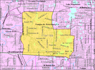
Carrollwood is a census-designated place (CDP) in northwestern Hillsborough County, Florida, United States. The population was 33,365 at the 2010 census. The census area includes the unincorporated communities of Carrollwood and Carrollwood Village. For the 2000 census the area was enumerated under the name "Greater Carrollwood" and had a population of 33,519. A similar area was listed as "Lake Carroll" in 1970 and 1980; for the 1990 census it was split into the smaller Carrollwood and Carrollwood Village CDPs.

Hillsborough Township is a township in Somerset County, in the U.S. state of New Jersey. As of the 2020 United States census, the township's population was 43,276, an increase of 4,973 (+13.0%) from the 2010 census count of 38,303, which in turn reflected an increase of 1,669 (+4.6%) from the 36,634 counted in the 2000 census.

Sun City Center is an unincorporated census-designated place (CDP) in southern Hillsborough County, Florida, United States. It is located south of Tampa and north of Sarasota on I-75. As of the 2020 census, the population was 30,952. The ZIP Code serving the community is 33573.
Highpoint is an unincorporated community in eastern Pinellas County, Florida, United States, near Tampa Bay. It is situated between Feather Sound and Largo. The area includes the census-designated place of South Highpoint.
East Tampa is an unincorporated community in Hillsborough County, Florida, United States. It is partially within the census-designated place (CDP) of Gibsonton. The ZIP code for East Tampa is 33619.

Carrollwood is an unincorporated community in Hillsborough County, Florida, United States. It is part of the larger census-designated place (CDP) of Carrollwood, which also includes the neighborhood of Carrollwood Village. A census-designated place corresponding just to Carrollwood existed during the 1990 census, with a population of 7,195. The ZIP code for Carrollwood is 33618.

Fort Lonesome is a rural area located in southeastern Hillsborough County, Florida, United States, 36 miles (58 km) southeast of Tampa. A sawmill briefly revived the area with a few houses and three stores in the early 1930s. It was short-lived: a fire destroyed the mill and eventually the "town" disappeared. Today, it is mainly a farming region.
Carrollwood Village is an unincorporated community in Hillsborough County, Florida, United States. Along with neighboring Carrollwood, it is part of the Carrollwood census-designated place. The ZIP codes for the community are 33624 and 33618. Carrollwood Village was its own census-designated place during the 1990 census, with a recorded population of 15,051.
Egypt Lake is an unincorporated community in northwestern Hillsborough County, Florida, United States. It is located within the census-designated place of Egypt Lake-Leto. It was a separate census-designated place from 1970 to 1990. The population as of the 1990 census was 14,580. The ZIP code for Egypt Lake is 33614.
Leto is an unincorporated community in northwestern Hillsborough County, Florida, United States. Along with Egypt Lake, it is a part of the census-designated place (CDP) of Egypt Lake-Leto. It was a separate CDP from 1970 to 1990, and was known as West Park in 1990. The population as of the 1990 census was 10,347.
Orient Park is an unincorporated community in Hillsborough County, Florida, United States. Along with East Lake, it is a part of the census-designated place (CDP) of East Lake-Orient Park. The ZIP code for the community is 33619.
Nowatney is an unincorporated community in northern Hillsborough County, Florida, United States. The community is within the census-designated place of University. The ZIP code for the community is 33613.
Sweetwater Creek is an unincorporated community in Hillsborough County, Florida, United States. It is part of the census-designated place (CDP) of Town 'n' Country. The ZIP code for the community is 33634.
Lake Fern is an unincorporated community in Hillsborough County, Florida, United States. Although a separate community, it is a part of the census-designated place (CDP) of Keystone. The ZIP code for the community is 33556. In 2000, it was part of the Citrus Park-Fern Lake [sic] census county division (CCD), which recorded an estimate population of 117,574 in 2007.
Bay Crest Park is an unincorporated community in Hillsborough County, Florida, United States.


