
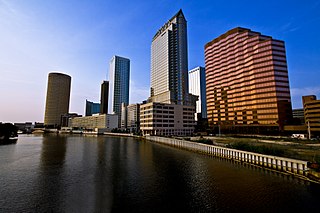
Hillsborough County is located in the west-central portion of the U.S. state of Florida. In the 2020 census, the population was 1,459,762, making it the fourth-most populous county in Florida and the most populous county outside the Miami metropolitan area. A 2021 estimate has the population of Hillsborough County at 1,512,070 people with a yearly growth rate of 1.34%, which itself is greater than the populations of 12 states according to their 2019 population estimates. Its county seat and largest city is Tampa. Hillsborough County is part of the Tampa–St. Petersburg–Clearwater Metropolitan Statistical Area.

Pasco County is located on the west central coast of the U.S. state of Florida. According to the 2020 census, the population was 561,691. Its county seat is Dade City, and its largest city is Zephyrhills. The county is named after Samuel Pasco.

Brandon is an unincorporated community and census-designated place (CDP) in Hillsborough County, Florida, United States. It is part of the Tampa–St. Petersburg–Clearwater Metropolitan Statistical Area. The population was 114,626 at the 2020 census, up from 103,483 at the 2010 census.

Plant City is an incorporated city in Hillsborough County, Florida, United States, approximately midway between Brandon and Lakeland along Interstate 4. The population was 39,764 at the 2020 census.
The Hillsborough River is a river located in the state of Florida in the United States. It arises in the Green Swamp near the juncture of Hillsborough, Pasco and Polk counties, and flows 60 miles (97 km) through Pasco and Hillsborough Counties to an outlet in the city of Tampa on Hillsborough Bay. It includes 4 nature trails extending for over 7 miles (11 km), making it popular among hikers. The name Hillsborough River first appeared on a British map in 1769. At the time, the Earl of Hillsborough was the British Secretary of State for the Colonies, and thus controlled the pensions of the surveyors working in the American colonies, which included East Florida.

U.S. Route 92 or U.S. Highway 92 is a 181-mile (291 km.) U.S. Route entirely in the U.S. state of Florida. The western terminus is at US 19 Alt. and SR 687 in downtown St. Petersburg. The eastern terminus is at SR A1A in Daytona Beach.

State Road 582 is an east–west state highway in Hillsborough County, Florida, United States. The current alignment of SR 582 is Fowler Avenue just south of the northern city limit of Tampa and Temple Terrace from Florida Avenue to US 301. It is the primary road to access of University of South Florida.

The Lee Roy Selmon Expressway is a 14.168-mile (22.801 km) all-electronic, limited access toll road in Hillsborough County, Florida. It connects the South Tampa neighborhood near MacDill Air Force Base with Downtown Tampa and the bedroom community of Brandon. The expressway was built in stages, opening between 1976 and 1987. An approximately 1.9-mile extension to the thoroughfare's western terminus opened to traffic on Monday, April 19, 2021.

Hillsborough Community College (HCC) is a public community college in Hillsborough County, Florida. It is part of the Florida College System.

State Road 553 is a 1.4-mile-long (2.3 km), north–south highway in Plant City, Florida connecting U.S. Route 92 (US 92) and Interstate 4 (I-4).

The William Glover Negro School or Glover School was a segregated school for Black children in Bealsville near Plant City, Florida. It is located at 5110 Horton Road. On November 29, 2001, it was added to the U.S. National Register of Historic Places.

U.S. Highway 41 (US 41) in the state of Florida is a north–south United States Highway. It runs 479 miles (771 km) from Miami in South Florida northwest to the Georgia state line north of the Lake City area. Within the state, US 41 is paralleled by Interstate 75 (I-75) all the way from Miami to Georgia, and I-75 has largely supplanted US 41 as a major highway.

U.S. Route 301 in Florida runs from the Sarasota-Bradenton-Venice, Florida Metropolitan Statistical Area northeast to the Greater Jacksonville Metropolitan Area. The road is a spur of U.S. Route 1, which it intersects in Callahan.
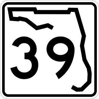
State Road 39 is a north–south state highway in eastern Pasco and Hillsborough County, Florida, United States. Between Plant City and Zephyrhills, the road is named Paul S. Buchman Highway. North of Zephyrhills, Florida the road is a secret state designation for U.S. Route 301 until the southern terminus of the concurrency with U.S. Route 98 south of Dade City, Florida.
There have been plans in Florida for expressways, but some were never constructed due to financial problems, community opposition and environmental issues.
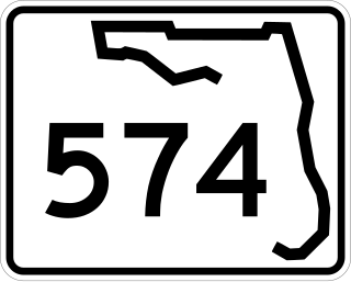
State Road 574 is an east–west state highway in Central Hillsborough County, Florida. It runs from northwestern Tampa to Plant City, and parallels County Road 574 west of Mango.
Hopewell is an unincorporated community in Hillsborough County, Florida, United States. It lies at an elevation of 102 feet (31 m) above sea level. Hopewell is located along Florida State Road 60 at the intersection of Hillsborough County Road 39 and southern terminus of Florida State Road 39.
Alafia is an unincorporated community in southeastern Hillsborough County, Florida, United States, between Plant City and Lithia near the intersection of Keysville Road and Florida State Road 39.
Picnic, also known as Hurrah, is an unincorporated community in southeastern Hillsborough County, Florida, United States, between Plant City and Lithia near the intersection of Carter Road and Florida State Road 39. It is best known as the home of Alafia River State Park.
Bealsville, originally named Howell's Creek, is an unincorporated community in southeastern Hillsborough County, Florida, United States, between Plant City and Lithia near the intersection of Horton Road and Florida State Road 60.


