
Cheval is an unincorporated census-designated place in Hillsborough County, Florida, United States. The population was 10,702 at the 2010 census, up from 7,602 at the 2000 census.

Egypt Lake-Leto is a census-designated place in an unincorporated part of Hillsborough County, Florida, United States. The population was 35,282 at the 2010 census. The area is located just north of Tampa International Airport. The ZIP code for Egypt Lake-Leto is 33614.

Northdale is an unincorporated census-designated place in Hillsborough County, Florida, United States. Northdale was named by the combination of the words in North Dale Mabry, the main highway through the Northdale area. The population was 22,079 at the 2010 census.
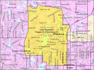
Lake Magdalene is a census-designated place (CDP) in Hillsborough County, Florida, United States. The population was 28,509 at the 2010 census.

Town 'n' Country is a census-designated place (CDP) in Hillsborough County, Florida, United States. The population was 85,951 at the 2020 census.

University is an unincorporated census-designated place in Hillsborough County, Florida, United States. The population was 41,163 at the 2010 census, up from 30,736 at the 2000 census. The University of South Florida is located just southeast of the community, within the Tampa city limits. The community is also known as "University West", mainly due to its location in relation to the university. The community is often notoriously referred to by locals as "Suitcase City" due to the high rate of transients.

Carrollwood is a census-designated place (CDP) in northwestern Hillsborough County, Florida, United States. The population was 33,365 at the 2010 census. The census area includes the unincorporated communities of Carrollwood and Carrollwood Village. For the 2000 census the area was enumerated under the name "Greater Carrollwood" and had a population of 33,519. A similar area was listed as "Lake Carroll" in 1970 and 1980; for the 1990 census it was split into the smaller Carrollwood and Carrollwood Village CDPs.
Dale Mabry Highway is a north–south road in Tampa, Florida. The majority of its length consists of three lanes each direction plus a central turn-lane and often includes a right-turn lane. It begins at the MacDill Air Force Base entrance in South Tampa and ends by merging with US 41 just north of the Pasco County border. The highway carries multiple designations, carrying US 92 for an approximately five-mile (8.0 km) stretch between Hillsborough Avenue and Gandy Boulevard.

East Tampa is an unincorporated community in Hillsborough County, Florida, United States. It is partially within the census-designated place (CDP) of Gibsonton. The ZIP code for East Tampa is 33619.
Carrollwood is an unincorporated community in Hillsborough County, Florida, United States. It is part of the larger census-designated place (CDP) of Carrollwood, which also includes the neighborhood of Carrollwood Village. A census-designated place corresponding just to Carrollwood existed during the 1990 census, with a population of 7,195. The ZIP code for Carrollwood is 33618.
Palma Ceia is a neighborhood located southwest of downtown Tampa, Florida in South Tampa. It is bounded by Miguel Street West of MacDill Avenue and Neptune Street East of MacDill Avenue to the north; Bay to Bay Boulevard from Dale Mabry to Himes and El Prado between Himes and the Crosstown Expressway to the south; MacDill Avenue between Neptune and San Miguel, Dale Mabry Highway between San Miguel and Bay to Bay and Himes between Bay to Bay and El Prado to the west; and the Lee Roy Selmon Expressway to the east. The street names throughout Palma Ceia are of Cuban origin, coming from streets in the old section of Havana. Historians say the most likely explanation is that Angel Cuesta, president of Cuesta-Rey cigars, shared a map of Havana with developer Thomas Palmer while discussing the area.
Carrollwood Village is an unincorporated community in Hillsborough County, Florida, United States. Along with neighboring Carrollwood, it is part of the Carrollwood census-designated place. The ZIP codes for the community are 33624 and 33618. Carrollwood Village was its own census-designated place during the 1990 census, with a recorded population of 15,051.
Palma Ceia West is a neighborhood within the city limits of Tampa, Florida, located just west of Palma Ceia. As of the 2000 census the neighborhood had a population of 2,531. The ZIP Codes serving the neighborhood are 33609 and 33629. The neighborhood is part of the South Tampa District.
Virginia Park is a neighborhood within the city limits of Tampa, Florida. As of the 2000 census the neighborhood had a population of 4,378. The ZIP Codes serving the area are 33611 and 33629.
Swann Estates is a neighborhood within the city limits of Tampa, Florida. As of the 2000 census the neighborhood had a population of 1,491. The ZIP Codes serving the neighborhood are 33609 and 33629.
Leto is an unincorporated community in northwestern Hillsborough County, Florida, United States. Along with Egypt Lake, it is a part of the census-designated place (CDP) of Egypt Lake-Leto. It was a separate CDP from 1970 to 1990, and was known as West Park in 1990. The population as of the 1990 census was 10,347.
Orient Park is an unincorporated community in Hillsborough County, Florida, United States. Along with East Lake, it is a part of the census-designated place (CDP) of East Lake-Orient Park. The ZIP code for the community is 33619.
Sweetwater Creek is an unincorporated community in Hillsborough County, Florida, United States. It is part of the census-designated place (CDP) of Town 'n' Country. The ZIP code for the community is 33634.
Lake Fern is an unincorporated community in Hillsborough County, Florida, United States. Although a separate community, it is a part of the census-designated place (CDP) of Keystone. The ZIP code for the community is 33556. In 2000, it was part of the Citrus Park-Fern Lake [sic] census county division (CCD), which recorded an estimate population of 117,574 in 2007.
Bay Crest Park is an unincorporated community in Hillsborough County, Florida, United States.


