Boyette, Florida

Last updated

Boyette, Florida
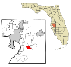
Hillsborough County Florida Incorporated and Unincorporated areas Boyette Highlighted.svg
Location in Hillsborough County and the state of Florida
Coordinates: 27°50′33″N82°17′8″W / 27.84250°N 82.28556°W / 27.84250; -82.28556
Country United States
State Florida
County Hillsborough
Area
  Total6.9 sq mi (17.8 km2)
  Land6.6 sq mi (17.1 km2)
  Water0.3 sq mi (0.7 km2)
Elevation
82 ft (25 m)
Population
 (2000)
  Total5,895
  Density854.3/sq mi (331.2/km2)
Time zone UTC-5 (Eastern (EST))
  Summer (DST) UTC-4 (EDT)
FIPS code 12-07825 [1]
GNIS feature ID0295147 [2]

Boyette is an unincorporated community and former census-designated place in Hillsborough County, Florida, United States. The population was 5,895 at the 2000 census. The CDP area merged with Riverview in 2010. [3]

Contents

Geography

According to the United States Census Bureau, the CDP had a total area of 6.9 square miles (18 km2), of which 6.6 square miles (17 km2) was land and 0.3 square miles (0.78 km2) (4.21%) was water.

Demographics

As of the census [1] of 2000, there were 5,895 people, 1,937 households, and 1,638 families residing in the community. The population density was 893.1 inhabitants per square mile (344.8/km2). There were 2,103 housing units at an average density of 318.6 per square mile (123.0/km2). The racial makeup of the community was 88.46% White, 5.39% African American, 0.63% Native American, 1.51% Asian, 0.07% Pacific Islander, 1.71% from other races, and 2.22% from two or more races. Hispanic or Latino of any race were 8.16% of the population.

There were 1,937 households, out of which 46.8% had children under the age of 18 living with them, 72.1% were married couples living together, 8.6% had a female householder with no husband present, and 15.4% were non-families. 11.2% of all households were made up of individuals, and 3.3% had someone living alone who was 65 years of age or older. The average household size was 3.04 and the average family size was 3.29.

In the community, the population was spread out, with 31.7% under the age of 18, 5.7% from 18 to 24, 32.9% from 25 to 44, 23.0% from 45 to 64, and 6.8% who were 65 years of age or older. The median age was 36 years. For every 100 females, there were 101.1 males. For every 100 females age 18 and over, there were 97.0 males.

The median income for a household in the community was $55,133, and the median income for a family was $56,818. Males had a median income of $41,446 versus $30,781 for females. The per capita income for the community was $21,057. About 5.5% of families and 5.9% of the population were below the poverty line, including 5.4% of those under age 18 and 6.8% of those age 65 or over.

Related Research Articles

Selmont-West Selmont is a census-designated place (CDP) in Dallas County, Alabama, United States. At the 2020 census, the population was 2,158.

<span class="mw-page-title-main">Sun Lakes, Arizona</span> CDP in Maricopa County, Arizona

Sun Lakes is an unincorporated community and census-designated place (CDP) in Maricopa County, Arizona, United States. The population was 14,868 at the 2020 census. Sun Lakes is an active adult community comprising five country club communities in three homeowner associations. These include the gated communities of Oakwood and IronWood (IronOaks), the gated and non-gated communities of Palo Verde and Cottonwood, and the non-gated community of Sun Lakes 1. Sun Lakes is a master-planned community developed by Robson Communities.

<span class="mw-page-title-main">New Kingman-Butler, Arizona</span> CDP in Mohave County, Arizona

New Kingman-Butler is an unincorporated community and census-designated place (CDP) in Mohave County, Arizona, United States, directly north of and bordering the city of Kingman. The population was 12,907 as of the 2020 census.

<span class="mw-page-title-main">Manatee Road, Florida</span> Census-designated place in Florida, United States

Manatee Road is a census-designated place (CDP) in Levy County, Florida, United States. The population was 2,244 at the 2010 census. At the 2000 census, the CDP was misspelled as "Manattee Road".

Reidland is an unincorporated community and census-designated place (CDP) in McCracken County, Kentucky, United States. The population was 4,526 at the 2020 census. It is part of the Paducah, KY-IL Metropolitan Statistical Area.

<span class="mw-page-title-main">Rancho Calaveras, California</span> Census-designated place in California, United States

Rancho Calaveras is a census-designated place (CDP) in Calaveras County, California, United States. The population was 5,325 at the 2010 census, up from 4,182 at the 2000 census.

<span class="mw-page-title-main">Napoleon, Michigan</span> Census-designated place & unincorporated community in Michigan, United States

Napoleon is an unincorporated community and census-designated place (CDP) in Jackson County in the U.S. state of Michigan. The population of the CDP was 1,258 at the 2010 census. It is located within Napoleon Township.

<span class="mw-page-title-main">West Ishpeming, Michigan</span> Census-designated place & unincorporated community in Michigan, United States

West Ishpeming is an unincorporated community and census-designated place (CDP) in Marquette County in the U.S. state of Michigan. The population was 2,552 at the 2020 census. The community is located mostly within Ishpeming Township with a small portion extending south into Tilden Township.

<span class="mw-page-title-main">Saginaw Township South, Michigan</span> Place in Michigan, United States

Saginaw Township South is an unincorporated community and former census-designated place (CDP) in Saginaw County in the U.S. state of Michigan. The community is located within Saginaw Charter Township, and the CDP boundaries consisted of the southern portion of the township. Saginaw Township North is in the northern portion of the township.

<span class="mw-page-title-main">Brownville, New Jersey</span> Populated place in Middlesex County, New Jersey, US

Brownville is an unincorporated community and census-designated place (CDP) located within Old Bridge Township in Middlesex County in the U.S. state of New Jersey. As of the 2010 United States Census, the CDP's population was 2,383.

<span class="mw-page-title-main">Fairview, Dutchess County, New York</span> Census-designated place in New York, United States

Fairview is a hamlet and census-designated place (CDP) in Dutchess County, New York, United States. The population was 5,515 at the 2010 census. It is part of the Poughkeepsie–Newburgh–Middletown, NY Metropolitan Statistical Area as well as the larger New York–Newark–Bridgeport, NY-NJ-CT-PA Combined Statistical Area.

<span class="mw-page-title-main">North Bellport, New York</span> Hamlet and census-designated place in New York, United States

North Bellport is a hamlet and census-designated place (CDP) located within the Town of Brookhaven, New York, United States. The population was 11,545 at the 2010 census.

<span class="mw-page-title-main">Park Layne, Ohio</span> Census-designated place in Ohio, United States

Park Layne is a census-designated place (CDP) in Bethel Township, Clark County, Ohio, United States. The population of the CDP was 4,248 at the 2020 census. It is part of the Springfield, Ohio Metropolitan Statistical Area. Park Layne became a CDP in the 1980 United States Census.

<span class="mw-page-title-main">Grandview, Hamilton County, Ohio</span> Census-designated place in Ohio, United States

Grandview is a census-designated place (CDP) in Hamilton County, Ohio, United States. The population was 1,312 at the 2020 census.

<span class="mw-page-title-main">Harbeck-Fruitdale, Oregon</span> Unincorporated community in the state of Oregon, United States

Harbeck-Fruitdale was formerly a census-designated place (CDP) in Josephine County, Oregon, United States, near Grants Pass. As of the 2000 census, the CDP population was 3,780. It includes the community of Fruitdale.

<span class="mw-page-title-main">Hyde, Pennsylvania</span> Census-designated place in Pennsylvania, United States

Hyde is an unincorporated community and census-designated place (CDP) in Clearfield County, Pennsylvania, United States. The population was 1,303 at the 2020 census.

<span class="mw-page-title-main">Cecil-Bishop, Pennsylvania</span> CDP in Pennsylvania, United States

Cecil-Bishop is a census-designated place (CDP) in Washington County, Pennsylvania, United States. The population was 2,730 at the 2020 census. The census-designated place encompasses two unincorporated communities: larger Cecil in the west and smaller Bishop in the east.

<span class="mw-page-title-main">Green Valley, South Dakota</span> CDP in South Dakota, United States

Green Valley is a census-designated place (CDP) and unincorporated community in Pennington County, South Dakota, United States. The population was 1,051 at the 2020 census.

<span class="mw-page-title-main">Van Buren (CDP), Maine</span> Census-designated place in Maine, United States

Van Buren is a census-designated place (CDP) comprising the main village within the town of Van Buren in Aroostook County, Maine, United States. The population of the CDP was 1,937 at the 2010 census, out of a population of 2,171 for the entire town.

<span class="mw-page-title-main">Eden (CDP), New York</span> Census-designated place in New York, United States

Eden is a hamlet and census-designated place (CDP) in Erie County, New York, United States. The population was 3,516 at the 2010 census. It is part of the Buffalo–Niagara Falls Metropolitan Statistical Area.

References

  1. 1 2 "U.S. Census website". United States Census Bureau . Retrieved January 31, 2008.
  2. "US Board on Geographic Names". United States Geological Survey. October 25, 2007. Retrieved January 31, 2008.
  3. Florida Population & Housing Unit data - 2010. United States Census Bureau. Retrieved 2013-08-19.