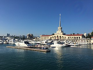
Sochi is the largest resort city in Russia. The city is situated on the Sochi River, along the Black Sea in the North Caucasus of Southern Russia, with a population of 466,078 residents, and up to 600,000 residents in the urban area. The city covers an area of 176.77 square kilometers (68.25 sq mi), while the Greater Sochi Area covers over 3,502 square kilometers (1,352 sq mi). Sochi stretches across 145 kilometers (90 mi), and is the longest city in Europe, the fifth-largest city in the Southern Federal District, the second-largest city in Krasnodar Krai, and the sixth-largest city on the Black Sea.
The Republic of Adygea, also known as the Adygean Republic, is a republic of Russia. It is situated in the North Caucasus of Eastern Europe. The republic is a part of the Southern Federal District, and covers an area of 7,600 square kilometers (2,900 sq mi), with a population of roughly 496,934 residents. It is an enclave within Krasnodar Krai and is the fifth-smallest Russian federal subject by area. Maykop is the capital and the largest city of Adygea, home to one-third of the republic's population.

Stavropol Krai, also known as Stavropolye, is a federal subject of Russia. It is geographically located in the North Caucasus region in Southern Russia, and is administratively part of the North Caucasian Federal District. Stavropol Krai has a population of 2,907,593, according to the 2021 Census.

Krasnodar Krai is a federal subject of Russia, located in the North Caucasus region in Southern Russia and is administratively a part of the Southern Federal District. Its administrative center is the city of Krasnodar. The third most populous federal subject in Russia, it had a population of 5,838,273 as of the 2021 Census.
Anapa is a town in Krasnodar Krai, Russia, located on the northern coast of the Black Sea near the Sea of Azov. Population: 81,863 (2021 Census); 58,990 (2010 Census); 53,493 (2002 Census); 54,796 (1989 Soviet census).

Armavir is a city in Krasnodar Krai, Russia, located on the left bank of the Kuban River. Population: 187,177 (2021 Census); 188,832 (2010 Census); 193,964 (2002 Census); 160,983 (1989 Soviet census). As of 2020, the city has a population of 188,960, while the agglomeration has a population of 207,570. Armavir is the second-largest industrial center of Krasnodar Krai, after Krasnodar.
Tuapse is a town in Krasnodar Krai, Russia, situated on the northeast shore of the Black Sea, south of Gelendzhik and north of Sochi. Population: 61,571 (2021 Census); 63,292 (2010 Census); 64,238 (2002 Census); 63,081 (1989 Soviet census).

Shovgenovsky District is an administrative and a municipal district (raion), one of the seven in the Republic of Adygea, Russia. It is located in the central northern portion of the republic and borders with Ust-Labinsky District of Krasnodar Krai in the north, Kurganinsky District of Krasnodar Krai in the north and northeast, Koshekhablsky District in the east and southeast, Giaginsky District in the south, Belorechensky District of Krasnodar Krai in the southwest, and with Krasnogvardeysky District in the west. The area of the district is 521.43 square kilometers (201.33 sq mi). Its administrative center is the rural locality of Khakurinokhabl. As of the 2010 Census, the total population of the district was 16,997, with the population of Khakurinokhabl accounting for 23.8% of that number.

Adlersky city district is the southernmost of four city districts of the city of Sochi in Krasnodar Krai, Russia, lying along the Black Sea coast near the southern Russian border with Georgia. The city district borders Maykopsky District of Adygea in the north, Mostovsky District of Krasnodar Krai in the east, Abkhazia in the south, and Khostinsky city district in the northwest. In the southwest, it is bordered by the Black Sea. Population: 76,534 (2010 Census); 69,120 (2002 Census); 68,827 (1989 Soviet census). Adlersky District was chosen to host the 2014 Winter Olympics. The historical center of the district is Adler Microdistrict (Адлер) – formerly classified as a town, but today a microdistrict of Adlersky city district – located at the mouth of the Mzymta River.

Krasnaya Polyana is an urban locality in Krasnopolyansky Settlement Okrug, which is under the administrative jurisdiction of Adlersky City District of the City of Sochi in Krasnodar Krai, Russia. Population: 4,598 (2010 Census); 3,969 (2002 Census); 3,300 (1989 Soviet census).

Dzhubga is a seaside resort situated 57 km west of Tuapse in Krasnodar Krai, Russia.

Krymsky District is an administrative district (raion), one of the thirty-eight in Krasnodar Krai, Russia. As a municipal division, it is incorporated as Krymsky Municipal District. It is located in the west of the krai. The area of the district is 1,601 square kilometers (618 sq mi). Its administrative center is the town of Krymsk. Population: 74,761 (2010 Census); 70,576 (2002 Census); 62,859 (1989 Soviet census). In 1939, the Greek Autonomous District was abolished and renamed Krymsky District.

Kurganinsky District is an administrative district (raion), one of the thirty-eight in Krasnodar Krai, Russia. As a municipal division, it is incorporated as Kurganinsky Municipal District. It is located in the east of the krai. The area of the district is 1,590 square kilometers (610 sq mi). Its administrative center is the town of Kurganinsk.

Leningradskaya is a rural locality and the administrative center of Leningradsky District in Krasnodar Krai, Russia. It is requested that the name of the town be changed. Population: 36,940 (2010 Census); 38,218 (2002 Census); 34,554 (1989 Soviet census).
Lazarevsky city district is one of four city districts of the city of Sochi in Krasnodar Krai, Russia. The city district borders Tuapsinsky District in the northwest, Apsheronsky District in the north, Maykopsky District of the Republic of Adygea in the northeast, Khostinsky city district in the east, and Tsentralny city district in the south. The administration of the district is located in Lazarevskoye Microdistrict. In the southwest, it is bordered by the Black Sea. Population: 63,894 (2010 Census); 63,239 (2002 Census); 64,006 (1989 Soviet census).
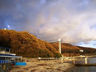
Khosta is a microdistrict in Khostinsky City District in Sochi, Krasnodar Krai, Russia, primarily known as a spa and a resort on the Black Sea coast. Khosta is located in the mouth of the Khosta River, between the center of Sochi and Adler. The area is served by the Khosta railway station.
Tsentralny city district is one of four city districts of the city of Sochi in Krasnodar Krai, Russia. Sometimes referred to as "Sochi proper", it borders Lazarevsky city district in the west and Khostinsky city district in the north and in the east. In the southwest, it is bounded by the Black Sea. Population: 137,677 (2010 Census); 133,935 (2002 Census); 137,968 (1989 Soviet census).
Matsesta is a microdistrict in Khostinsky City District in Sochi, Krasnodar Krai, Russia, primarily known as a spa and resort on the Black Sea coast. Matsesta is located in the mouth of the Matsesta River, halfway between the center of Sochi and Adler. Matsesta is located in the Matsesta River valley and consists of four parts. Novaya Matsesta is located at the coast, Srednyaya Matsesta is upstream the river, and Staraya Matsesta is even further from the sea. Verkhnyaya Matsesta is located uphill from Srednyaya Matsesta.

The Sochinsky okrug was a district (okrug) of the Black Sea Governorate of the Caucasus Viceroyalty of the Russian Empire. It bordered the Kuban Oblast to the north, the Tuapsinsky okrug to the west, the Sukhumi okrug to the east, and the Black Sea to the south. The area of the Sochinsky okrug mostly corresponds to the Krasnodar Krai region of the Russian Federation. The district was eponymously named for its administrative centre, Sochi.