Related Research Articles

South Kivu is one of 26 provinces of the Democratic Republic of the Congo (DRC). Its capital is Bukavu.
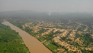
The Ulindi River is a tributary of the Lualaba River in the Democratic Republic of the Congo (DRC). There is a proposal to build a hydroelectric power plant on the river to power a gold mining project.
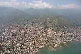
Uvira is the capital city of the Uvira Territory in the South Kivu Province of the Democratic Republic of the Congo (DRC). It is situated between Lake Tanganyika and the Mitumba Mountains and covers an area of approximately 16km.
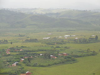
Minembwe is a cluster of several villages located in the highlands of the Lulenge, within the Fizi Territory of South Kivu Province in the Democratic Republic of the Congo (DRC). It is situated at an altitude of about 2,500 meters above sea level, in a hilly and mountainous region covered with forests, which provides fertile land for agriculture. It is approximately 150 kilometers south of Bukavu, the capital city of South Kivu. The region is also home to various streams and rivers that flow into Lake Tanganyika, the second-deepest lake in the world.
Daniel P. Biebuyck was a Belgian scholar of Central African art.
The Kipupu massacre occurred on 16 July 2020 in the South Kivu village of Kipupu in the Mwenga Territory in the eastern Democratic Republic of the Congo. Gunmen belonging to the Ngumino and Twiganeho militias of the Banyamulenge community attacked the village and reportedly killed 220 people according to provincial lawmakers, while independent analysts state only 18 people were killed.

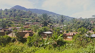
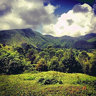
Lulenge is one of the four sectors of Fizi Territory of the South Kivu Province in the eastern region of the Democratic Republic of the Congo (DRC). It is situated near the Kiloba and Makena villages, at an altitude of 943 meters. Its capital is Kilembwe. Lulenge is bordered to the north by the Itombwe sector and Mwenga Territory. In the east, it is bordered by Lake Tanganyika and the Mutambala sector. In the south, it is bordered by the N’gangya sector, and in the west by Shabunda Territory.
Kasika is a village located in the Luindi Chiefdom within the Mwenga Territory of the South Kivu Province, situated in the eastern region of the Democratic Republic of the Congo (DRC). Geographically positioned at 965 meters above sea level, Kasika strategically lies near Kihovu and Kahulile, approximately 108 kilometers from Bukavu, near the Rwandan border. The region is more than clusters of mud huts built around a Catholic parish on a hill overlooking a valley. It was the headquarters of the customary chief of the Nyindu ethnic community, whose house and office sat on a hill opposite the parish, a series of large, red-brick structures with cracked ceramic shingles as roofing, laced with vines.
Kinyandonyi is a village in the Rutshuru Territory of the North Kivu Province, Democratic Republic of the Congo. Kinyandonyi is situated 10 km east of the city of Kiwanja in Bukoma groupement, in the Bwisha Chiefdom and 85 km north of the capital of the province Goma. The region is inhabited by the Hunde people as well as some remaining autochthonous populations of African Pygmies, including the Twa people and the Mbuti people. In addition to the Hunde, Twa, and Mbuti, there are other ethnic groups, including the Nyanga, Lega, Kumu, Hutu and Tutsi.

Katogota is a village located in the Itara-Luvungi grouping within the Bafuliiru Chiefdom in Uvira Territory of the South Kivu Province in the Democratic Republic of the Congo (DRC). Situated approximately 60 km south of Bukavu, Katogota is in close proximity to the Kamonyi and Rusagara villages, near the border regions of Rwanda and Burundi.

Kamanyola is one of the groupements (groupings) within the Ngweshe Chiefdom of the Walungu Territory. It is located in the Ruzizi Plain in the South Kivu Province of the Democratic Republic of the Congo (DRC), sharing a border with Rwanda and Burundi. Kamanyola stands at a height of 901 meters and is closely situated to the suburb of Mwaro and the village of Mubombo.
Kaniola Groupement, also known as Kanyola, is one of the 16 groupements (groupings) that constitute the Ngweshe Chiefdom of the Shi people. Kaniola Groupement is located at an elevation of 1800 meters and is situated 64 km from Bukavu city. It shares borders with the Kahuzi-Biéga National Park and the Nindja Chiefdom to the northeast, while being bordered by the Izege groupement and Walungu groupement to the east. It is also bordered by the Burhale groupement and Mulamba groupement in the west.

Mutambala is a sector that constitutes one of the four sectors in the Fizi Territory of the South Kivu Province in the eastern part of the Democratic Republic of the Congo. Mutambala is situated near Lake Tanganyika, in the west by the Lulenge sector, in the north by the Tangani'a sector, and in the south by the Ngandja sector. It has a surface area of 777 km 2. The sector consists of five groupings (groupements), including the Basimukindja groupings, the Batombwe groupings, and the Babwari groupings.
Bibogobogo, also known as Bibokoboko in Kibembe, is a village in the middle plateaus of the Mutambala Sector in the Fizi Territory in the South Kivu Province of the Democratic Republic of the Congo (DRC). It is situated in the forested mountains and middle plateaus, overlooking Baraka in the south-west, near Kisombe and Bibokoboko II villages. Bibogobogo shares the borders with Uvira Territory in the North, the Mwenga Territory and Shabunda Territory in the West, the Kalemie Territory in the South, and Lake Tanganyika in the East. The regional soil is composed of metals, including sodium, potassium, calcium, magnesium, iron, aluminium and mercury, making it suitable for gold plating, mercury pollution, pollution index and agriculture. Despite being rich in forest biodiversity, the region is in a state of poverty and insecurity which hampers any attempt at sustainable development. The ongoing ethnic conflict in the region continues to affect communities identified as Babembe, Bafuliiru, Babwari, Babuyu, Banyindu, Balega (Warega), Bamushi, and Banyamulenge.

The Nyindu people, are an ethnic group predominantly found along the Ulindi River in the north, west, and south, as well as the Kilungutwe River, located in the Mwenga Territory in the southern part of South Kivu Province in the eastern region of the Democratic Republic of the Congo (DRC). The Nyindu people belong to the Bantu ethnic group and linguistic family, which is among the most populous and diverse ethnic groups in the South Kivu Province. They are known for their traditional agricultural practices, which include cultivating crops such as maize, cassava, and beans. They also engage in animal husbandry, particularly with cattle. The Nyindu are organized into clans, and each clan has a chief who serves as a leader and arbitrator.
Kilungutwe is a small village in the Luindi Chiefdom, located in the valley of the Kilungutwe River in the Mwenga Territory of the South Kivu Province. Situated in the eastern part of the Democratic Republic of the Congo (DRC), Kilungutwe is positioned nearby neighboring villages of Kirukungutu and Chowe. The region is a melting pot for many ethnic groups, boasting a diverse ethnocultural landscape. It is also a point of confluence for numerous ethnic groups, including the Lega, Nyindu, Shi, Fuliiru, Holoholo, Bwari, Vira, Hunde, Nyanga, Bembe, and Amba people.
The Makobola massacre occurred from December 30, 1998, to January 2, 1999, in the small village of Makobola, located approximately 15 kilometers south of Uvira, on the border between Fizi Territory and Uvira Territory in the South Kivu Province of the Democratic Republic of the Congo (DRC). The Rally for Congolese Democracy, a predominantly Tutsi Rwandan-backed armed group led by Ernest Wamba dia Wamba, killed over 800 civilians, largely belonging to the Babembe community.

The Lemera massacre, also known as the Lemera Attack or Lemera Battle, which occurred on October 6, 1996, was a massacre perpetrated by the Alliance of Democratic Forces for the Liberation of Congo (AFDL) at Lemera Hospital, a medical facility in the small town of Lemera, about 85 kilometers northwest of Uvira in the South Kivu Province of the Democratic Republic of the Congo (DRC). 37 individuals were killed, according to the United Nations Mapping Report.
The Luindi Chiefdom, also known as Lwindi Chiefdom, is a traditional administrative unit located in the Mwenga Territory of the South Kivu Province in the eastern region of the Democratic Republic of the Congo (DRC). It is situated in the mountainous area of the Itombwe Massif, which is known for its rich biodiversity and unique wildlife.
The Kasika massacre took place on August 24, 1998, in the villages of Kasika, Kilungutwe, Kalama, and Zokwe, located in the Luindi Chiefdom of the Mwenga Territory in the South Kivu Province, situated in the eastern part of the Democratic Republic of the Congo (DRC). Troops from the Rally for Congolese Democracy (RCD) and Rwandan Patriotic Army (RPA), primarily composed of Tutsi armed forces, killed over 1,000 civilians, predominantly belonging to the Nyindu community.
References
- ↑ "Bukavu : Joseph Kabila clôture sa visite au Sud-Kivu". Radio Okapi (in French). 2009-08-14. Retrieved 2023-05-08.
- ↑ Bulletin des séances, Volume 1, Issues 1-6 (in French). Paris, France: Académie royale des sciences coloniales. 1955. pp. 667–675.
- 1 2 Stearns, Jason (March 27, 2012). Dancing in the Glory of Monsters: The Collapse of the Congo and the Great War of Africa. New York, New York: PublicAffairs. p. 257. ISBN 9781610391597.
- ↑ "Google Maps". Google Maps. Retrieved 2023-07-04.
- ↑ "Des Hydrocarbures et de l'environnement" (PDF) (in French). Bukavu, Democratic Republic of the Congo. 2016-06-23. p. 6. Retrieved 2023-05-08.
- ↑ Association française pour l'avancement des sciences (1953). Actes du congrès, Volume 72 (in French). Secrétariat de l'Association. p. 379.
- ↑ Yamada, Takako (1984). Nyindu Culture and the Plant World : The Dynamic Relationship between the Knowledge on Plant Use and the Change in House Form. Kyoto, Japan: Kyoto University.
- ↑ "KILUNGUTWE Geography Population Map cities coordinates location - Tageo.com". www.tageo.com. Retrieved 2023-05-08.
- ↑ Biebuyck, Daniel P. (1981). Statuary from the Pre-Bembe Hunters: Issues in the Interpretation of Ancestral Figurines Ascribed to the Basikasingo-Bembe-Boyo. Tervuren, Belgium: Royal Museum of Central Afrika. pp. English, French, and Dutch.
- ↑ Biebuyck, Daniel P. (1973). Lega Culture; Art, Initiation, and Moral Philosophy Among a Central African People. Berkeley, California: University of California Press. p. 3. ISBN 9780520020856.
- ↑ "IV: Eastern Congo: Findings". www.hrw.org. 1999. Retrieved 2023-05-08.
- ↑ "RDC: 22 ans après le massacre, retour à Kasika où la blessure des charniers reste vive". RFI (in French). 2020-09-04. Retrieved 2023-05-08.
- ↑ "RDC: polémique après un tweet de l'ambassadeur du Rwanda sur le massacre de Kasika". RFI (in French). 2020-08-26. Retrieved 2023-05-08.
- ↑ "Life for women in the country that 'never turned the page of conflict'". The Independent. 2019-06-12. Retrieved 2023-05-08.
- ↑ "ACHPR, Democratic Republic of the Congo v. Burundi, Rwanda and Uganda | How does law protect in war? - Online casebook". casebook.icrc.org. Retrieved 2023-05-08.
- ↑ "20 Years On from the Kasika Massacre, Women Survivors Share Their Stories | Women For Women". Women for Women International. Retrieved 2023-05-08.