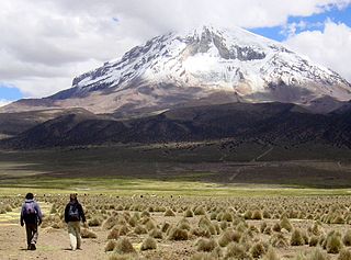
Tomás Frías is a province in the northern parts of the Bolivian Potosí Department. Its capital is Potosí which is also the capital of the department. The province is named after the former president Tomás Frías Ametller.

Sajama is a province in the northwestern parts of the Bolivian Oruro Department.

Turco Municipality is the second municipal section of the Sajama Province in the Oruro Department in Bolivia, and was founded on February 15, 1957. Its seat is Turco, situated 154 km west of Oruro at an altitude of 3,860 m. The municipality covers an area of 3,973 km², not taking into account the area of Laca Laca Canton.
Malla Municipality is the fourth municipal section of the Loayza Province in the La Paz Department, Bolivia. Its seat is Malla.

Potosí Municipality is the capital municipality of the Tomás Frías Province in the Potosí Department in Bolivia. Its seat is Potosí which is the capital of the department as well.

Yocalla Municipality is the second municipal section of the Tomás Frías Province in the Potosí Department in Bolivia. Its seat is Yocalla.

Waylla is a mountain in the Andes located on the border of Bolivia and Chile in the Cordillera Occidental.

Kimsa Chata is a mountain in the Andes of Bolivia, about 4,648 m (15,249 ft) high. It is one of the highest elevations of the Waylla Marka mountain range that runs down from Waylla Marka (Huayllamarca) to Qhurqhi (Corque) west of Uru Uru Lake. Kimsa Chata is located in the Oruro Department, Carangas Province, Qhurqhi Municipality, Tarukachi Canton, or on the border of the Carangas Province and the Saucari Province.

The Potosí mountain range in Bolivia is situated east and southeast of the city of Potosí. It is at least 25 km long stretching from north to south. Its highest mountain is Khunurana (Anaruyu) rising up to 5,071 m (16,637 ft). The features of the range are considered the product of volcanic activity known as the Khari Khari caldera. The caldera is about 40 km long and 25 km at its widest point.

Khari Khari is a mountain in the Andes in the Potosí Department of Bolivia. It is the second highest elevation in the Potosí mountain range rising up to (5,040 m. It is also the highest mountain in the Khari Khari mountain range, the northern part of the Potosí mountain range.

The Khari Khari Lakes are two closely connected artificial lakes, San Ildefonso and San Pablo situated in the Khari Khari mountain range of Bolivia. The lakes lie about 8 km east of Potosí in the Potosí Department, Tomás Frías Province, Potosí Municipality, northeast of the lakes named San Sebastián and Planilla which are also artificial lakes.

Mawk'a Tampu is a mountain in the Andes of Bolivia. It lies in the Potosí Department at the border of the provinces Tomás Frías and Cornelio Saavedra. Its summit reaches a height of about 4,940 metres (16,207 ft) above sea level. Mawk'a Tampu is situated in the Khari Khari mountain range east of Potosí. It lies east of the Khari Khari and the Kimsa Kunturiri group and southeast of the Jatun Tiyu Lakes.

Kimsa Kunturiri is a group of three mountains in the Andes of Bolivia in the Potosí Department at the border of Tomás Frías Province and Cornelio Saavedra Province. The peaks are about 5,020 m, 4,980 m and 4,960 m high. The Kimsa Kunturiri group is situated in the Khari Khari mountain range east of Potosí. It lies north of the Kimsa Waylla group, between the lakes Jatun Wak'ani (Jatun Huacani) and Juch'uy Wak'ani (Juchuy Huacani) in the west and the Jatun Tiyu Lakes in the east.

Jatun Q'asa is a mountain in the Khari Khari mountain range of the Bolivian Andes, about 5,023 m high. It is located in the Potosí Department, Tomás Frías Province, Potosí Municipality. It lies north of the plain called Jatun Molino Pampa and the Sip'uruni River. Jatun Q'asa lies near Q'illu Q'asa, Q'illu Urqu and Yuraq Yuraq.

Uma Jalanta is a mountain in the Khari Khari mountain range of the Bolivian Andes, about 4,760 m (15,617 ft) high. It is situated south east of Potosí in the Potosí Department, Tomás Frías Province, Potosí Municipality. Uma Jalanta lies north-east of Challwiri Lake and the mountain Illimani.

Illimani is a mountain in the Khari Khari mountain range of the Bolivian Andes, about 5,030 m (16,503 ft) high. It is situated south-east of Potosí in the Potosí Department, Tomás Frías Province, Potosí Municipality. Illimani lies south-west of the mountain Uma Jalanta, north-east of Challwiri Lake and north of Illimani Lake.

Yuraq Yuraq is a mountain in the Khari Khari mountain range of the Bolivian Andes, about 4,920 m high. It is situated southeast of Potosí in the Potosí Department. Yuraq Yuraq lies southeast of Illimani and northeast of Q'illu Urqu.

Wak'ani is a mountain in the Khari Khari mountain range in the Andes of Bolivia. It is situated in the Potosí Department, Tomás Frías Province, east of Potosí. Wak'ani lies south and south-west of the mountains Khari Khari and Kimsa Waylla, north-west of the mountain Illimani and south-east of the Khari Khari Lakes.

Waylla Tira is a 4,324-metre-high (14,186 ft) mountain in the Andes of Bolivia. It is located in the Potosí Department, Tomás Frías Province, Potosí Municipality. Waylla Tira lies east of the Challwiri River, an affluent of the Pillku Mayu.

Waylla Q'asa is a 4,568-metre-high (14,987 ft) mountain in the Bolivian Andes. It is located in the Potosí Department, Tomás Frías Province, Yocalla Municipality.


