Kintampo South District | |
|---|---|
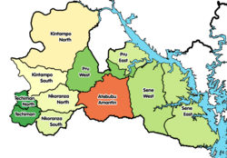 Districts of Bono East Region | |
 Kintampo South District Location of Kintampo South District within Bono East Region | |
| Coordinates: 7°53′52.8″N1°46′15.6″W / 7.898000°N 1.771000°W | |
| Country | |
| Region | Bono East Region |
| Capital | Jema |
| Government | |
| • District Executive | Kojo Nyame Datiakwa |
| Area | |
• Total | 1,510 km2 (580 sq mi) |
| Population (2021) | |
• Total | 89,126 [1] |
| Time zone | UTC+0 (GMT) |
Kintampo South District is one of the eleven districts in Bono East Region, Ghana. [2] [3] [4] Originally it was formerly part of the then-larger Kintampo District on 10 March 1989, until the southern part of the district was split off to create Kintampo South District on 12 November 2003 (effectively 17 February 2004); thus the remaining part has been renamed as Kintampo North District ; which it was later elevated to municipal district assembly status on 1 November 2007 (effectively 29 February 2008) to become Kintampo North Municipal District . The district assembly is located in the northern part of Bono East Region and has Jema as its capital town.