Techiman Municipal District | |
|---|---|
Municipal district | |
 The Sunyani Cocoa House | |
Seal | |
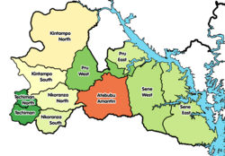 Districts of Bono East Region | |
 Techiman Municipal District Location of Sunyani Municipal District within Bono East Region | |
| Coordinates: 7°35′13″N1°56′06″W / 7.58694°N 1.93500°W | |
| Country | |
| Region | Bono East |
| Capital | Techiman |
| Government | |
| • Municipal Chief Executive | Hon Adjei Mensah |
| Area | |
• Total | 1,119 km2 (432 sq mi) |
| Population (2021) | |
• Total | 243,335 [1] |
| Time zone | UTC+0 (GMT) |
Techiman Municipal District is one of the eleven districts in Bono East Region, Ghana. [2] [3] It was originally created as an ordinary district assembly on 10 March 1989, when it was known as Techiman District, until the northern part of the district was split off to create Techiman North District on 28 June 2012; thus the remaining part has been retained as Techiman District. This was later elevated to municipal district assembly status and was renamed as Techiman Municipal District in that same year. The municipality is located in the western part of Bono East Region and has Techiman as its capital town.