
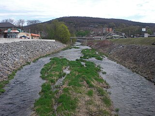
Shamokin Creek is a tributary of the Susquehanna River in Northumberland County, Pennsylvania, in the United States. It is approximately 32.4 miles (52.1 km) long and flows through Mount Carmel, Mount Carmel Township, Coal Township, Shamokin, Ralpho Township, Shamokin Township, Snydertown, Upper Augusta Township, and Sunbury. The watershed of the creek has an area of 137 square miles (350 km2). It experiences significant impacts by abandoned mine drainage and many abandoned mine drainage discharges are in its watershed. Various other impairments also affect parts of the creek's watershed. Shamokin Creek is in the Appalachian Mountains section of the Ridge and Valley physiographic province. Rock formations consisting of sandstone, shale, and anthracite deposits occur in the watershed.
Chest Creek is a tributary of the West Branch Susquehanna River in Cambria County and Clearfield County, in Pennsylvania, in the United States. It is approximately 40.4 miles (65.0 km) long and flows through Allegheny Township, East Carroll Township, Clearfield Township, Patton, Chest Township, and Elder Township in Cambria County and Westover borough, Chest Township, Newburg, Bell Township, and Mahaffey in Clearfield County. Although it is considered by the Pennsylvania Department of Environmental Protection to be impaired by situation, it is a coldwater fishery or a high-quality coldwater fishery throughout its length. The watershed of the creek has an area of 129.22 square miles (334.7 km2).

Mahanoy Creek is a 51.6-mile-long (83.0 km) tributary of the Susquehanna River in Northumberland and Schuylkill counties, Pennsylvania. There are at least 35 sources of acid mine drainage in the creek's watershed. Anthracite was mined in the upper part of the Mahanoy Creek watershed in the 19th and 20th centuries. Mahanoy Creek's tributaries include Schwaben Creek, Zerbe Run, Little Mahanoy Creek, Shenandoah Creek, and North Mahanoy Creek. Little Mahanoy Creek and Schwaben Creek are two streams in the watershed that are unaffected by acid mine drainage. Schwaben Creek has a higher number and diversity of fish species than the main stem.
Mahoning Creek is a tributary of the Susquehanna River in Columbia County and Montour County, in Pennsylvania, in the United States. It is approximately 10.6 miles (17.1 km) long and flows through Madison Township in Columbia County and West Hemlock Township, Derry Township, Valley Township, Mahoning Township, and Danville in Montour County. The watershed of the creek has an area of 39.6 square miles (103 km2). Its tributaries include Kase Run, Mauses Creek, and Sechler Run. Mahoning Creek is designated as a Trout-Stocking Fishery and a Migratory Fishery for part of its length and as a Warmwater Fishery and a Migratory Fishery for the remainder.

Mugser Run is a 8.0-mile-long (12.9 km) stream in Columbia County, Pennsylvania, in the United States. It is a tributary of South Branch Roaring Creek. Mugser Run is located in Locust and Cleveland Townships. Forested land and agricultural land are by far the most common uses of land in the watershed. Brown trout and rainbow trout are found in the creek. The main rock formations are the Trimmers Rock Formation and the Catskill Formation–Buddys Run formation.

Muddy Run is a tributary of the West Branch Susquehanna River in Northumberland County, Pennsylvania, in the United States. It is 5.4 miles (8.7 km) in length. The creek is several miles northeast of the community of Milton. Main land uses include agricultural land and forest. The area of the creek's watershed is 11.4 square miles (30 km2), most of which is agricultural land. Muddy Run is entirely within Turbot Township. Most of the rock in the watershed is shale. The most common soil series is the Berks-Weikert-Bedington series.
Warrior Run is a tributary of the West Branch Susquehanna River in Northumberland County, Pennsylvania, in the United States. It is 9.5 miles (15.3 km) in length. It has a watershed area of 21.6 square miles and the watershed is in Northumberland and Lycoming Counties. The main soil series in the watershed is the Berks-Weikert-Bedington series and the main land uses are agriculture and forest. The communities of Watsontown, Turbotville, and McEwensville are all in or near the watershed. The Warrior Run watershed was inhabited by Europeans in the early 1770s. Several mills and forts were built along it.

Delaware Run is a tributary of the West Branch Susquehanna River in Northumberland County, Pennsylvania, in the United States. It is 7.4 miles (11.9 km) long. It flows through Delaware Township, starting in the Muncy Hills. The watershed has an area of 11.7 square miles in Northumberland and Lycoming Counties. Delaware Run was reached by Europeans as early as 1737 and an area near it settled in 1769 and the community of Dewart is near Delaware Run.

Wolf Run is a tributary of Muncy Creek in Lycoming County, Pennsylvania, in the United States. It is 7.6 miles (12.2 km) in length. The stream flows through Wolf Township, Muncy Township, and Muncy Creek Township. The stream's watershed has an area of 10.8 square miles. Slightly over two million pounds of sediment flow through the stream every year. A fort existed near Wolf Run for several hundred years until the late 1800s or early 1900s. At least three bridges cross the stream.

Limestone Run is a tributary of the West Branch Susquehanna River, in Montour County and Northumberland County, in Pennsylvania, in the United States. It is 8.8 miles (14.2 km) long and flows through Limestone Township in Montour County and Turbot Township and Milton in Northumberland County. The watershed has an area of 11.6 square miles (30 km2). Slightly under 2,500,000 pounds (1,100,000 kg) of sediment flow through the stream annually. The stream's watershed is in the ridge and valley physiographic province.

Turtle Creek is a tributary of the West Branch Susquehanna River in Union County, Pennsylvania, in the United States. It is 8.4 miles (13.5 km) long and flows through Limestone Township, Buffalo Township, and East Buffalo Township. The watershed of the creek has an area of 12.7 square miles (33 km2). The creek is designated as an impaired waterbody, with the cause of the impairment being siltation and the source being agriculture. It has a daily sediment load of 6,372 pounds (2,890 kg). The main surficial rock types in the creek's watershed include shale, carbonate, and sandstone. The creek is in the ridge and valley physiographic province.

Montour Run is a tributary of Fishing Creek in Columbia County, Pennsylvania. It is the last named tributary to join the creek and is 3.1 miles (5.0 km) long. The stream's watershed has an area of approximately 4.7 square miles and is located in Montour Township, Columbia County and Cooper Township, Montour County. The annual load of sediment in the watershed is 4,248,000 pounds (1,927,000 kg), most of which comes from agricultural lands. Minnows live in the stream.

There are 17 named tributaries of the main stem of Fishing Creek, a 30-mile-long (50 km) stream in Columbia County, Pennsylvania, in the United States and a tributary of the Susquehanna River. The creek also has numerous sub-tributaries. The creek's watershed has an area of 385 square miles (1,000 km2). The watersheds of Little Fishing Creek and Huntington Creek, Fishing Creek's two largest tributaries, make up nearly 45 percent of the Fishing Creek watershed.

Deerlick Run is a tributary of Fishing Creek in Columbia County, Pennsylvania, in the United States. It is 3.8 miles (6.1 km) long. The stream flows through Mount Pleasant Township and Orange Township. The annual load of sediment in it is 8,522,400.0 pounds (3,865,695.6 kg). The stream's watershed has an area of 6.1 square miles, most of which is agricultural land. There are also large areas of forested land in the watershed.
Lick Run is a tributary of the West Branch Susquehanna River in Clearfield County, Pennsylvania, in the United States. It is 11.6 miles (18.7 km) long and flows through Lawrence Township, Pine Township, and Goshen Township. Tributaries of the stream include Fork Run, Jerrys Run, and Flegals Run.

Mud Run is a tributary of Green Creek in Columbia County, Pennsylvania, in the United States. It is 5.7 miles (9.2 km) long and flows through Greenwood Township. The stream's watershed has an area of 13.3 square miles and is located in Greenwood Township, Orange Township, and Mount Pleasant Township. The stream is in the ridge and valley physiographic province. Its annual load of sediment is 4,394,600 pounds (1,993,400 kg). The Kramer Covered Bridge crosses the stream.
Mud Creek is a tributary of Chillisquaque Creek in Columbia County and Montour County in Pennsylvania, in the United States. It is approximately 8.3 miles (13.4 km) long and flows through Madison Township, Columbia County and Derry Township, Montour County. The main tributaries of the creek are unnamed tributaries. The creek's watershed has an area of 17.70 square miles and is in West Hemlock Township, Montour County as well as the two townships it flows through. The watershed is mostly agricultural and forested and the main developed areas are Washingtonville and Jerseytown.

Wilson Run is a tributary of Kipps Run in Northumberland County, Pennsylvania, in the United States. It is approximately 3.6 miles (5.8 km) long and flows through Rush Township and Riverside. The watershed of the stream has an area of 3.27 square miles (8.5 km2). The drainage basin is considered to be a Coldwater Fishery and a Migratory Fishery. At least three bridges cross the stream and a mill historically existed on it. Sandstone has been observed in its vicinity.

Dalmatia Creek is a tributary of the Susquehanna River in Northumberland County, Pennsylvania, in the United States. It is approximately 2.8 miles (4.5 km) long and flows through Lower Mahanoy Township. The watershed of the creek has an area of 2.80 square miles (7.3 km2). The creek has no named tributaries, but several unnamed ones. Both it and its tributaries are designated as impaired waterbodies due to sedimentation/siltation from crop-related agriculture and vegetation removal. Streambank erosion also occurs in the watershed. The creek is in the Ridge and Valley physiographic province.
Hoffer Creek is a tributary of the Susquehanna River in Snyder County, Pennsylvania, in the United States. It is approximately 3.1 miles (5.0 km) long and flows through Chapman Township. The watershed of the creek has an area of 2.34 square miles (6.1 km2). At least part of the creek is designated as an impaired waterbody due to sedimentation/siltation from grazing-related agriculture. The creek is in the ridge and valley physiographic province, and the geology consists mostly of intermedded sedimentary rock and sandstone.


![[4]](./Kipps_Run#cite_note-rush.jpg-4)