Budapest Honvéd Football Club, commonly known as Budapest Honvéd or simply Honvéd, is a Hungarian sports club based in Kispest, Budapest, with the colours of red and black. The club is best known for its football team. Honvéd means the Homeland Defence. Originally formed as Kispest AC, they became Kispest FC in 1926 before reverting to their original name in 1944.

Ferencváros is the 9th district of Budapest, Hungary.

Józsefváros is the 8th district of Budapest, Hungary. It is the part of the city centre in the wider sense as one of the 18–19th century older suburbs, close to Belváros.

Kőbánya is the 10th district of Budapest and one of the largest by territory. It is located in southeast Pest, easily accessible from the downtown by Metro 3, whose terminus is named Kőbánya-Kispest.

Erzsébetváros is the 7th district of Budapest, situated on the Pest side of the Danube. The inner half of the district was the historic Jewish quarter of Pest. The Dohány Street Synagogue, the largest functioning synagogue in Europe, is located in this district. Currently it is the most densely populated district of Budapest with 29,681.3 person per km2. In 1910 Erzsébetváros had 152,454 inhabitants. During the socialist era Erzsébetváros's population decreased rapidly, because young people and families moved to the newer "panelized" boom districts. Gentrification and recovery started in the middle of the 2000s.

Kőbánya-Kispest is the southern terminus of the M3 Line of the Budapest Metro. It is the only station of the line that is above ground. The station was opened on 20 April 1980 as part of the extension from Nagyvárad tér.

Határ út is a station on the M3 (North-South) line of the Budapest Metro. Near the station, there are several tram and bus terminus, and a shopping centre. Határ út station named after the adjacent street Határ út, which literally means "(City) Border Street". Before the formation of Greater Budapest it was the border of Budapest Capital. The station was opened on 20 April 1980 as part of the extension from Nagyvárad tér to Kőbánya-Kispest.
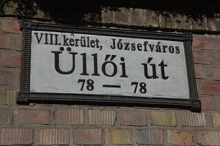
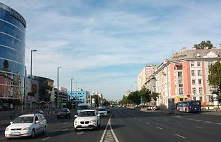
Üllői út is a major transport artery in Budapest, Hungary. Üllői út is the longest avenue in Budapest. It is 15.6 km long and nearly perfectly straight.

Zugló is the official name of the 14th district of Budapest, the capital of Hungary. It is a large and mixed neighborhood, with communist era style highrise apartments sprinkled between decently kept one house residential streets. Városliget, the City Park is located at the western part of the district. Its popularity comes from the fact that it has leafy suburb style neighbourhoods closest to the city center.
Vecsés is a town of 20,550 inhabitants in Budapest metropolitan area, Pest County, Hungary, situated adjacent to Budapest Ferenc Liszt International Airport.
Dénes Györgyi was a Hungarian architect, a member of the Györgyi-Giergl artistic family.
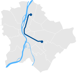
Line 3 is the third and longest line of the Budapest Metro. It runs in a general north-south direction parallel to the Danube on the Pest side, roughly following Váci út south from Újpest to the city center, then following the route of Üllői út southeast to Kőbánya-Kispest. Its daily ridership is estimated at 500,000. Like metro line M1, it does not serve Buda.

Újbuda is the 11th district of Budapest, Hungary. It is the most populous district of Budapest with 137,426 inhabitants (2008). Until the 1890s, Újbuda's present territory was a field south of the historical town of Buda. The construction of a new residential area started in the 1900s, the present district was formed in 1930. From 1880 to 1980, Újbuda's population increased from 1,180 to 178,960. There are boulevards, avenues with tram lines, and communist-era housing estates in the district. Line 4 of the Budapest metro passes through Újbuda.
The Wekerle estate is a part of Budapest's XIX. district. Kispest, formerly a suburb was administratively attached to Budapest in 1950 along with several other settlements of Greater Budapest.
Váci út is one of the widest and busiest avenues in Budapest, Hungary. It is about 12 kilometers (7.5 mi) long and has four to eight traffic lanes.

Hungária körgyűrű is the longest and busiest boulevard, also the widest city street in Budapest, Hungary. It is 13 km long and has 6–10 traffic lanes with a rapid tram line on the median of the boulevard. It consists of three parts: Róbert Károly körút, Hungária körút and Könyves Kálmán körút.

District XVII of Budapest is a suburban district of Budapest on the left bank of the Danube, in the eastern part of the capital. It is Budapest's largest district, with an area of 54.82 km2, and home to nearly 90,000 people, making it the seventh most populous district of Budapest. Towns that were different in nature, but closely connected, were annexed to the capital in 1950 as part of the Greater Budapest plan. It is one of the most beautifully located districts of Pest, which is partly located as high as the 235 meters Gellért Hill. As the district is part of the Pest Plain, which gradually rises from the Danube to the east, the district's area is almost entirely hilly. The 241 meter high Erdő Hill, the highest point of the Pest side and the Pest Plain is also located here.

Route 200E is a bus route in Budapest. Alongside the 100E express service, it is one of two bus lines serving Ferenc Liszt International Airport. During the day, the line runs between the airport and the nearest Budapest Metro station, Kőbánya-Kispest; at night, it runs to Határ út. 200E operates at all times and is operated by Budapesti Közlekedési Zrt. (BKV) for Budapesti Közlekedési Központ (BKK).