
The Ball Range is a mountain range on the Continental Divide between Vermilion Pass and Red Earth Pass in Kootenay National Park, Canada. The range is named after John Ball, a politician who helped secure funding for the Palliser expedition.

Pyramid Mountain is a mountain in Jasper National Park, Alberta, Canada, named for its pyramid-like shape. James Hector named the mountain in 1859 due to its appearance from the Athabasca River valley on the eastern side of the peak.
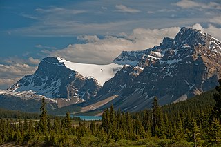
Crowfoot Glacier is located in Banff National Park, Alberta, Canada, 32 km (20 mi) northwest of Lake Louise, and can be viewed from the Icefields Parkway. The glacier is situated on the northeastern flank of Crowfoot Mountain.
Ruby Mountain, locally known as Old Volcano, is a cinder cone in Stikine Region, British Columbia, Canada, located 23 km (14 mi) northeast of Atlin and 6 km (4 mi) south of Mount Barham. A recent collapse on the volcano's eastern side created a large landslide which dissects this side of Ruby Mountain. The volcano is the largest feature within the Atlin Volcanic Field.
Castle Rock is a volcanic plug located 13 km (8 mi) west of Iskut and 8 km (5 mi) northwest of Tuktsayda Mountain in British Columbia, Canada. Castle Rock is part of the Pacific Ring of Fire that includes over 160 active volcanoes and is in the Klastline Group of the Northern Cordilleran Volcanic Province and last erupted in the Pleistocene.
Round Mountain is an eroded volcanic outcrop in the Garibaldi Volcanic Belt in British Columbia, Canada, located 8 km southwest of Eanastick Meadows, 9 km (6 mi) east of Brackendale and 10 km (6 mi) south of Mount Garibaldi. It is the highpoint of Paul Ridge and is located in the southwest corner of Garibaldi Provincial Park. Round Mountain formed as a result of subduction of the Juan de Fuca Plate beneath the North American Plate, known as the Cascadia subduction zone. Round Mountain last erupted during the Pleistocene.

Alberni Valley is a broad valley located at the head of Alberni Inlet on Vancouver Island in British Columbia, Canada. It is home to Port Alberni, Sproat Lake and other outlining areas. The term is largely used as a synonym for Greater Port Alberni and adjoining communities but is used in a larger regional sense as well. Various local organizations and companies use the term "Alberni Valley" in their name, e.g. the Alberni Valley Times and Alberni Valley News newspapers the Alberni Valley Chamber of Commerce and the Alberni Valley Bulldogs minor hockey team. The Canadian pioneer, Joe Drinkwater lived in Alberni Valley during the late nineteenth and early twentieth centuries.
Yeda Peak is a volcanic peak of the Spectrum Range on the Tahltan Highland of northwestern British Columbia, Canada, located 57 km (35 mi) southwest of Tatogga and 5 km (3 mi) south of Kitsu Peak. It is believed Yeda Peak last erupted during the Pliocene period.

Mount Clarke is a mountain in southwestern British Columbia, Canada, located 21 km (13 mi) northwest of Hemlock Valley and 6 km (4 mi) south of Grainger Peak. It is part of the Douglas Ranges, the southernmost subdivision of the Pacific Ranges which in turn form part of the Coast Mountains.
Mount Somolenko is a volcanic peak in southwestern British Columbia, Canada, located 83 km (52 mi) east of Rivers Inlet and 7 km (4 mi) south of Mount Silverthrone. It is the highest peak south of Mount Silverthrone in the Ha-Iltzuk Icefield.
Mount Fitzgerald is a volcanic peak in southwestern British Columbia, Canada, located 84 km (52 mi) east of Rivers Inlet and 4 km (2 mi) east of Mount Silverthrone.
Mount Overill is a volcanic peak in southwestern British Columbia, Canada, located 81 km (50 mi) east of Rivers Inlet and 2 km (1 mi) northwest of Mount Somolenko.

Fang Peak is a mountain in southwestern British Columbia, Canada, located 91 km (57 mi) east of Rivers Inlet and 8 km (5 mi) southeast of Mount Fitzgerald.

Meszah Peak is a volcanic cone located 66 km (41 mi) north of Telegraph Creek and 136 km (85 mi) southwest of Zus Mountain in British Columbia, Canada. It is the highest peak of the Level Mountain Range, a cluster of bare peaks on the summit of the massive Level Mountain shield volcano, which forms the most voluminous and most persistent eruptive centre in the Northern Cordilleran Volcanic Province.
The Red Tusk is a mountain in the Tantalus Range of the Pacific Ranges in southwestern British Columbia, Canada, located 5 km (3.1 mi) southeast of Mount Tantalus and 11 km (6.8 mi) west of Cheekye.

Mount Tantalus is a 2,608-metre (8,556-foot) mountain in southwestern British Columbia, Canada, located 24 km (15 mi) southeast of Falk Lake and 134 km (83 mi) south of Monmouth Mountain. It is the highest mountain in the Tantalus Range of the Pacific Ranges and is famous for its snow-covered face.
Mount Brew is a mountain located 12 km (7 mi) south of Lillooet and 44 km (27 mi) north of Skihist Mountain in south-central British Columbia, Canada. It lies on the western side of the Fraser River and is the third-highest mountain of the Lillooet Ranges, after Skihist Mountain and Petlushkwohap Mountain in the Cantilever Range to the west of Lytton.
Nuthinaw Mountain is a mountain on the Stikine Plateau in northern British Columbia, Canada, located east of Tutsingale Mountain and 72 km (45 mi) northwest of Dease Lake on the north side of Tachilta Lakes. It is a product of subglacial volcanism during the Pleistocene period when this area was covered by thick glacial ice, forming a subglacial volcano that never broke through the overlying glacial ice known as a subglacial mound.
Jarvis Pass is a mountain pass in Kakwa Provincial Park in the Northern Rockies of British Columbia, Canada, located to the north of Kakwa Lake, on the British Columbia-Alberta boundary, and therefore is on the Continental Divide. It was one of the many passes surveyed as a route for the Canadian Pacific Railway in the 1870s.
Mamquam Mountain is a mountain in the Pacific Ranges of the Coast Mountains in southwestern British Columbia, Canada, located 6 km (3.7 mi) southeast of Eanastick Meadows and 22 km (14 mi) east of Brackendale. It represents the highest summit of the Mamquam Icefield and lies at the southern end of Garibaldi Provincial Park. Mamquam Mountain was named on September 2, 1930, in association with the Mamquam River.


