Kozhikode South

Last updated

Kozhikode South
Feroke Tile factory.jpg
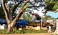
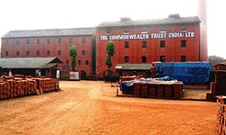
Commonwealth Tile Factory, Feroke
Coordinates: 11°08′29″N75°49′47″E / 11.14135°N 75.82970°E / 11.14135; 75.82970
Country India
State Kerala
Beypore Uru Sd11-boom.JPG
Beypore Uru
Farook College Farook college Main gate Kozhicode.JPG
Farook College

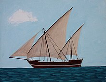
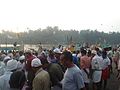
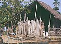
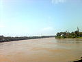
Kozhikode South is an outgrowth of Kozhikode city in Kerala, India. Kozhikode South refers to areas like Beypore, Feroke, Areekkad, Nallalam, Cheruvannur, Ramanattukara, Kadalundi and Pantheerankavu. Suburbs like Beypore are famous for boat making. [1]

Contents

Suburbs and Townships

History

The word Kozhikode or Calicut originally referred to the Palayam and Valiyangadi regions only. When the city grew, Nadakkavu and Mavoor Road were also considered part of the city. Today, Medical College area, West Hill area and Kallayi area are also considered part of the city. Suburbs like Feroke, Cheruvannur, Ramanattukara and Pantheerankavu are not treated part of Kozhikode city because they have their own separate administrative structure.

See also

Location

Related Research Articles

<span class="mw-page-title-main">Kozhikode</span> Metropolis in Kerala, India

Kozhikode, also known in English as Calicut, is a city along the Malabar Coast in the state of Kerala in India. It has a corporation limit population of 609,224 and a metropolitan population of more than 2 million, making it the second most populous metropolitan area in Kerala and the 19th largest in India. Kozhikode is classified as a Tier 2 city by the Government of India.

<span class="mw-page-title-main">Chaliyar</span> River in Kerala, India

Chaliyar River is the fourth longest river in Kerala at 169 km in length. The Chaliyar is also known as Chulika River, Nilambur River or Beypore River as it nears the sea. Pothukal, Chungathara, Nilambur, Mampad, Edavanna, Kavanoor, Perakamanna, Areekode, Kizhuparamba, Elamaram, Cheekkode, Vazhakkad, Vazhayur, Cheruvadi, Edavannappara, Mavoor, Peruvayal, Feroke and Beypore are some of the towns/villages situated along the banks of Chaliyar. It mainly flows through Malappuram district. Its tributaries flow through both the districts of Malappuram and Kozhikode. The bank of river Chaliyar at Nilambur region is also known for natural Gold fields. Explorations done at the valley of the river Chaliyar in Nilambur has shown reserves of the order of 2.5 million cubic meters of placers with 0.1 gram per cubic meter of gold. It originates at Ilambaleri hills of Nilgiri Mountains in Nilgiris district, which is also near Wayanad-Malappuram district border. It flows mainly through the erstwhile region of Eranad, and finally empties into the Arabian Sea at Beypore port, opposite to Chaliyam harbour.

Beypore or Beypur is an ancient port town and a locality town in Kozhikode district in the state of Kerala, India. It is located opposite to Chaliyam, the estuary where the river Chaliyar empties into Arabian Sea. Beypore is part of Kozhikode Municipal Corporation. The place was formerly known as Vaypura / Vadaparappanad and also as Beydary. Tippu Sultan, ruler of Mysore, named the town "Sultan Pattanam". There is a marina and a beach while Beypore port is one of the oldest ports in Kerala, which historically traded with the Middle East. Beypore is noted for building wooden ships, known as dhows or urus in the Malayalam language. These ships were usually bought by Arab merchants for trading and fishing but are now used as tourist ships. According to Captain Iwata, founder member of the Association of Sumerian ships in Japan, Sumerian ships might have been built in Beypore. There is evidence to prove that Beypore had direct trade links with Mesopotamia and was a prominent link on the maritime silk route. The first railway line of Kerala was laid in 1861 from Tirur to Beypore (Chaliyam) passing through Tanur, Parappanangadi, Vallikkunnu, and Kadalundi.

<span class="mw-page-title-main">Kozhikode district</span> District of Kerala state, India

Kozhikode, or Calicut district, is one of the 14 districts in the Indian state of Kerala, along its southwestern Malabar Coast. The city of Kozhikode, also known as Calicut, is the district headquarters. The district is 67.15% urbanised. Kozhikode city is the fashion capital of Kerala.

<span class="mw-page-title-main">Feroke</span> Municipality in Kerala, India

Feroke is a Municipality and a part of Kozhikode metropolitan area under Kozhikode Development Authority (K.D.A) in the Kozhikode district of the Indian state of Kerala.

<span class="mw-page-title-main">Conolly Canal</span> Canal in India

Conolly Canal, sometimes spelled as Canoly Canal, is the part of the West coast canal (WCC) network of Kerala and the canal was constructed by combining the rivers and streams along the coast with the intention of creating a vast waterway from Kozhikode to Kochi. It was constructed in the year 1848 under the orders of then collector of Malabar, H.V. Conolly, initially to facilitate movement of goods to Kallayi Port from hinter lands of Malabar through Kuttiyadi and Korapuzha river systems.

<span class="mw-page-title-main">Olavanna</span> Village in Kerala, India

Olavanna is a panchayat in Kozhikode district in the Indian state of Kerala. Olavanna is the most populous panchayat in kerala. It is located 10 km from Kozhikode City. Olavanna panchayath shares the border with Kozhikode corporation and Perumanna panchayath. At first it was a large agricultural area. Today there are many small and large scale industries.Pantheerankavu is the major town in the panchayat. There are also small marketplaces such as the Olavanna Chungam, Kodinattumukku, Mathara, Palazhi, Kunnathupalam, Iringallor. The railway station is around 10 kilometres away and the nearest airport is Calicut international Airport. HiLite Mall is located in Palazhi junction.

<span class="mw-page-title-main">Ramanattukara</span> Municipality/Suburb in Kozhikode, Kerala, India

Ramanattukara is a municipality census town in Kozhikode district in the Indian state of Kerala. This town was formerly called Kadungan Chira village. Ramanattukara is located 15 km away from Kozhikode city.

<span class="mw-page-title-main">Idimuzhikkal</span> Census town in Kerala, India

Idimuzhikkal or Chelembra is a town in Malappuram district, Kerala, India. Chelembra is the Panchayath and Idimuzhikal is the capital of this Panchayath. Chelembra grama panchayat in the district.

<span class="mw-page-title-main">Tenhipalam</span> Census town in Kerala, India

Thenhipalam is a census town and a panchayat in Tirurangadi taluk in Malappuram district of Kerala, India, with a population of 27,273 as per 2001 census, consisting of 13,293 males and 13,980 females. Tenhipalam forms a portion of the Malappuram metropolitan area as of 2011 Census. University of Calicut, the first university in the Malabar region, is located north-west part of the Panchayat. 'Chelari' is the main commercial place in Tenhipalam panchayat while 'Panambra' is considered the headquarters of the panchayat. The small town between Chelari and the university is called Kohinoor.

<span class="mw-page-title-main">Kadalundi</span> Village in Kerala, India

Kadalundi is a village in Kozhikode district, Kerala, India. It is a coastal village close to the Arabian Sea. Kadalundi is famous for its bird sanctuary, which is home to various migratory birds during certain seasons and has been recently declared as a bio-reserve. The Kadalundi-Vallikkunnu community reserve is the first community reserve in Kerala. The Kadalundi River and the Chaliyar river, two of the longest rivers of Kerala, merges with the Arabian Sea at Kadalundi. The first railway line in Kerala was laid in 1861 from Tirur to Chaliyam through Tanur, Parappanangadi, Vallikkunnu, and Kadalundi.

<span class="mw-page-title-main">Cheruvannur Nallalam</span> Town in Kerala, India

Cheruvannur is a census town and Cheruvannur-Nallalam Part of Kozhikode Corporation.

<span class="mw-page-title-main">Eranad</span> Erstwhile Province in Kerala, India

Eranad also known as Ernad refers to the erstwhile province in the midland area of Malabar, consisting of Malappuram and nearby regions such as Anakkayam, Manjeri, Kondotty, Nilambur, etc. Currently Eranad Taluk is a Taluk in Malappuram district. Eranad was ruled by a Samanthan Nair clan known as Eradis, similar to the Vellodis of neighbouring Valluvanad and Nedungadis of Nedunganad. The rulers of Eranad were known by the title Eralppad/Eradi. They also used the title Thirumulpad.

<span class="mw-page-title-main">Cherukavu</span> Census town in Kerala, India

Cherukavu is a census town in Malappuram district in the state of Kerala, India.

<span class="mw-page-title-main">Chaliyam</span> Village in Kerala, India

Chaliyam is a village situated at the estuary of Chaliyar in Kozhikode district of Kerala, India. Chaliyam forms an island, bounded by the Chaliyar in the north, and River Kadalundi in south, and the Conolly Canal in the east. It is located just opposite to Beypore port. Chaliyam was the former terminus of the South-West Line of the Madras Railway. Chaliyam is also famous for the Guinness World Records holder Muhammed Adil, a P.M who covered around seven km in the Chaliyar River with his hand and legs tied with ropes.

<span class="mw-page-title-main">Paruthippara</span> Village in Kerala, India

Paruthippara or Kodampuzha is a small village near Feroke in Kozhikode District. The village is considered an industrial belt as a large number of small-scale are established here for a long time.

<span class="mw-page-title-main">Airport Road, Kozhikode</span> Place in India

Airport Road, Kozhikode is an important road in Kozhikode, India. It extends from Thondayad Junction to Calicut Airport, about 20 km away. The road passes through Palazhi, Pantheeramkavu, Ramanattukara and Kondotty Thurakkal before reaching the airport.

Kozhikode district has an extensive network of road, rail and air travel services. Kozhikode city is the epicenter of the district. Vatakara and Thamarassery are other transport hubs.

Aikkarappadi is a town in the Malappuram district in Kerala, India. Agriculture and education are its main industries.

<span class="mw-page-title-main">South Malabar</span> Geographical / Historical Area in Kerala, India

South Malabar refers to a geographical area of the southwestern coast of India covering some parts of the present-day Kerala state. South Malabar covers the regions included in present-day Kozhikode taluk of Kozhikode district, the whole area of Malappuram district, Chavakkad taluk of Thrissur district, and Palakkad district, excluding parts of Chittur taluk. The Fort Kochi region of Kochi city also historically belongs to South Malabar. The term South Malabar refers to the region of the erstwhile Malabar District south to the river Korapuzha, and bears a high cultural similarity to both the Cochin and the North Malabar regions.

References

  1. "The boat-makers of Beypore - The Hindu".

Best Grocery Shopping in Calicut