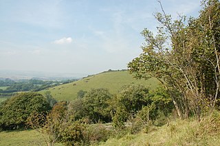
Wye Downs is a stretch of chalk downland and woodland located on the North Downs near the village of Wye in Kent. The site is a national nature reserve owned and managed by Natural England and comprises several coombes formed by periglacial action during the last ice age. The most spectacular coombe is known as the Devil's Kneading Trough.

The R117 road is a regional road in Ireland. The route (north-south) starts Harcourt Road at the end of the South Circular Road on the southside of Dublin city centre. It crosses the Grand Canal and goes through the suburbs of Ranelagh, Milltown, Windy Arbour, Dundrum, Sandyford, Stepaside and Kilternan before passing through the Scalp into County Wicklow.

Merdzavan, is a village in the Armavir Province of Armenia, located at the western suburbs of the capital Yerevan, north of the Parakar village.

Khashtarak is a village in the Tavush Province of Armenia. Within the village is a recently built church, and nearby west and southeast are abandoned medieval settlements with khachkars.

Lchap is a village in the Gegharkunik Province of Armenia.

Çərəkən is a village in the Jabrayil Rayon of Azerbaijan.

Puçuq is a village in the Quba Rayon of Azerbaijan. The village forms part of the municipality of Gömürdəhnə.

Zapady is a village in the administrative district of Gmina Godzianów, within Skierniewice County, Łódź Voivodeship, in central Poland. It lies approximately 3 kilometres (2 mi) east of Godzianów, 8 km (5 mi) south-west of Skierniewice, and 44 km (27 mi) east of the regional capital Łódź.

Sadowie is a village in the administrative district of Gmina Kocmyrzów-Luborzyca, within Kraków County, Lesser Poland Voivodeship, in southern Poland. It lies approximately 17 km (11 mi) north-east of the regional capital Kraków.

Basznia Dolna is a village in the administrative district of Gmina Lubaczów, within Lubaczów County, Subcarpathian Voivodeship, in south-eastern Poland, close to the border with Ukraine. It lies approximately 7 kilometres (4 mi) east of Lubaczów and 88 km (55 mi) east of the regional capital Rzeszów.

Niekłań Wielki is a village in the administrative district of Gmina Stąporków, within Końskie County, Świętokrzyskie Voivodeship, in south-central Poland. It lies approximately 7 kilometres (4 mi) north-east of Stąporków, 15 km (9 mi) east of Końskie, and 33 km (21 mi) north of the regional capital Kielce.

Grobla is a village in the administrative district of Gmina Rytwiany, within Staszów County, Świętokrzyskie Voivodeship, in south-central Poland. It lies approximately 3 kilometres (2 mi) south-west of Rytwiany, 6 km (4 mi) south of Staszów, and 58 km (36 mi) south-east of the regional capital Kielce.

Ćwiersk is a village in the administrative district of Gmina Raciąż, within Płońsk County, Masovian Voivodeship, in east-central Poland. It lies approximately 6 kilometres (4 mi) south-east of Raciąż, 19 km (12 mi) north-west of Płońsk, and 82 km (51 mi) north-west of Warsaw.

Śliwiny is a village in the administrative district of Gmina Tczew, within Tczew County, Pomeranian Voivodeship, in northern Poland. It lies approximately 5 kilometres (3 mi) south of Tczew and 35 km (22 mi) south of the regional capital Gdańsk.
Kocibórz is a village in the administrative district of Gmina Reszel, within Kętrzyn County, Warmian-Masurian Voivodeship, in northern Poland.

Wojny is a village in the administrative district of Gmina Biała Piska, within Pisz County, Warmian-Masurian Voivodeship, in northern Poland. It lies approximately 8 kilometres (5 mi) east of Biała Piska, 26 km (16 mi) east of Pisz, and 113 km (70 mi) east of the regional capital Olsztyn.

Lubowo is a settlement in the administrative district of Gmina Tuczno, within Wałcz County, West Pomeranian Voivodeship, in north-western Poland. It lies approximately 7 kilometres (4 mi) north-east of Tuczno, 20 km (12 mi) west of Wałcz, and 108 km (67 mi) east of the regional capital Szczecin.
Pertoltice is a village and municipality in Kutná Hora District in the Central Bohemian Region of the Czech Republic.
Popovnjak is a village situated in Despotovac municipality in Serbia.
Shur Mast-e Rudbar is a village in Rastupey Rural District, in the Central District of Savadkuh County, Mazandaran Province, Iran. At the 2006 census, its population was 138, in 43 families.


