Koźle

Last updated • 2 min readFrom Wikipedia, The Free Encyclopedia
Koźle
Kozle, Rynek z fontanna.jpg
Rynek (Market Square) in Koźle
POL Kozle COA.svg
Poland adm location map.svg
Red pog.svg
Koźle
Opole Voivodeship location map.svg
Red pog.svg
Koźle
Coordinates: 50°20′7″N18°8′45″E / 50.33528°N 18.14583°E / 50.33528; 18.14583
CountryFlag of Poland.svg  Poland
Voivodeship Opole
County Kędzierzyn-Koźle
Urban Gmina Kędzierzyn-Koźle
First mentioned12th century
Town rights1281
Merged into Kędzierzyn-Koźle 1975
Time zone UTC+1 (CET)
  Summer (DST) UTC+2 (CEST)
Vehicle registration OK

Koźle (German : Cosel) is a district of Kędzierzyn-Koźle, Poland, located in the western part of the city at the junction of the Kłodnica and Oder rivers, c.50 km southeast of Opole. The district has a Roman Catholic church, a medieval chateau, remains of a 19th-century fortress and a high school. Koźle's industries include a shipyard and an inland port.

Contents

History

Saint Sigismund church Kedzierzyn-Kozle st. Sigismund church.jpg
Saint Sigismund church

The settlement was first mentioned in the early 12th-century Gesta principum Polonorum , the oldest Polish chronicle. Its name comes from the Polish word kozioł, which means "goat". As a result of the fragmentation of Poland, from 1281 to 1355 Koźle was the seat of a splinter eponymous duchy ruled by a local branch of the Piast dynasty. Also in 1281, Koźle obtained town rights. After 1355, it remained under the rule of other branches of the Polish Piast dynasty until 1532, when it was absorbed to Bohemia. In 1431, Duke Konrad VII the White founded a Monastery of the Order of Friars Minor in Koźle. [1] It was besieged several times during the Thirty Years War, and in 1645, it returned to Polish rule under the House of Vasa.

It fell to Prussia by the 1742 Treaty of Breslau. Frederick II converted it into a fortress which held against Austrian sieges in 1758, 1759, 1760 and 1762. [2] In 1807 it almost withstood[ specify ] a siege by the Von Deroy brigade of the Bavarian Army, which was allied with Napoleonic France. From 1871 it was part of the German Empire. In 1903, the Polish Bank Ludowy was founded in the town. [3] Polish insurgents captured the part of the town east of the Oder during the 1921 Third Silesian Uprising, however, the town remained part of Germany in the interbellum. Local Polish activists were intensively persecuted by the Germans since 1937. [4] During World War II, the Germans operated three forced labour subcamps (E2, E153, E155) of the Stalag VIII-B/344 prisoner-of-war camp in the town. [5] In the final stages of the war, in 1945, a German-conducted death march of thousands of prisoners of several subcamps of the Auschwitz concentration camp passed through the town towards the Gross-Rosen concentration camp. [6] With the bulk of Silesia, it was among territories regained by Poland after World War II. However, 6,000 bomb craters were recorded in the Koźle Basin ranging from 16 feet (4.9 m) to 49 feet (15 m) in diameter, as American and British bombers dropped a total of 39,137 bombs in the region starting from February 1943, which was used by the German government for industrial fuel production. [7]

In the wake of Polish takeover of the region, many of the townspeople were expelled and some were arrested for speaking German. [8]

Notable residents

Related Research Articles

<span class="mw-page-title-main">Gryfino</span> Place in West Pomeranian Voivodeship, Poland

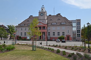
Gryfino is a town in Pomerania, northwestern Poland, with 21,393 inhabitants (2017). It is also the capital of Gryfino County in West Pomeranian Voivodeship.

<span class="mw-page-title-main">Kędzierzyn-Koźle</span> Place in Opole Voivodeship, Poland

Kędzierzyn-Koźle is a city in southern Poland, the administrative center of Kędzierzyn-Koźle County. With 58,899 inhabitants as of 2021, it is the second most-populous city in the Opole Voivodeship.

<span class="mw-page-title-main">Strzelce Opolskie</span> Place in Opole Voivodeship, Poland

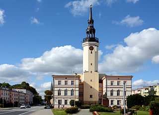
Strzelce Opolskie is a town in southern Poland with 17,900 inhabitants (2019), situated in the Opole Voivodeship. It is the capital of Strzelce County.

<span class="mw-page-title-main">Racibórz</span> Place in Silesian Voivodeship, Poland

Racibórz is a city in Silesian Voivodeship in southern Poland. It is the administrative seat of Racibórz County.

<span class="mw-page-title-main">Zakrzewo, Złotów County</span> Village in Greater Poland Voivodeship, Poland

Zakrzewo is a village in Złotów County, Greater Poland Voivodeship, in north-central Poland. It is the seat of the gmina called Gmina Zakrzewo. It lies approximately 10 kilometres (6 mi) north-east of Złotów and 114 km (71 mi) north of the regional capital Poznań.

<span class="mw-page-title-main">Lower Lusatia</span> Historical region in Germany and Poland

Lower Lusatia is a historical region in Central Europe, stretching from the southeast of the German state of Brandenburg to the southwest of Lubusz Voivodeship in Poland. Like adjacent Upper Lusatia in the south, Lower Lusatia is a settlement area of the West Slavic Sorbs whose endangered Lower Sorbian language is related to Upper Sorbian and Polish.

<span class="mw-page-title-main">Biała, Opole Voivodeship</span> Place in Opole Voivodeship, Poland

Biała, informally Biała Prudnicka, is a small town in southern Poland, located in the southern part of Opole Voivodeship in Prudnik County near the border with the Czech Republic. It is the administrative seat of Gmina Biała. As of December 2021, it has a population of 2,336.

<span class="mw-page-title-main">Stalag VIII-B</span> WWII German prisoner-of-war camp in Silesia

Stalag VIII-B was a German Army prisoner-of-war camp during World War II, later renumbered Stalag-344, located near the village of Lamsdorf in Silesia. The camp initially occupied barracks built to house British and French prisoners in World War I. At this same location there had been a prisoner camp during the Franco-Prussian War of 1870-71.

<span class="mw-page-title-main">Pierzchowice</span> Village in Pomeranian Voivodeship, Poland

Pierzchowice is a village in the administrative district of Gmina Mikołajki Pomorskie, within Sztum County, Pomeranian Voivodeship, in northern Poland. It lies approximately 5 kilometres (3 mi) south-west of Mikołajki Pomorskie, 11 km (7 mi) south-east of Sztum, and 67 km (42 mi) south-east of the regional capital Gdańsk.

<span class="mw-page-title-main">Kolonowskie</span> Place in Opole Voivodeship, Poland

Kolonowskie is a town in Strzelce County, Opole Voivodeship, Poland, with 3,309 inhabitants (2019). It is the seat of Gmina Kolonowskie which has been officially bilingual in Polish and German since 2006.

<span class="mw-page-title-main">Przemków</span> Place in Lower Silesian Voivodeship, Poland

Przemków is a town in Polkowice County, Lower Silesian Voivodeship, in western Poland. It is the seat of the administrative district called Gmina Przemków. The town lies approximately 19 kilometres (12 mi) west of Polkowice, and 97 kilometres (60 mi) northwest of regional capital Wrocław.

<span class="mw-page-title-main">Nowe Kramsko</span> Village in Lubusz Voivodeship, Poland

Nowe Kramsko is a village in the administrative district of Gmina Babimost, within Zielona Góra County, Lubusz Voivodeship, in western Poland. It lies approximately 4 kilometres (2 mi) south-west of Babimost and 28 km (17 mi) north-east of Zielona Góra. It is situated on the northern shore of Lake Wojnowskie.

<span class="mw-page-title-main">Bierawa</span> Village in Opole Voivodeship, Poland

Bierawa is a village in Kędzierzyn-Koźle County, Opole Voivodeship, in south-western Poland. It is the seat of the gmina called Gmina Bierawa. It lies approximately 8 kilometres (5 mi) south-east of Kędzierzyn-Koźle and 48 km (30 mi) south-east of the regional capital Opole.

<span class="mw-page-title-main">Kotlarnia</span> Village in Opole Voivodeship, Poland

Kotlarnia is a village in the administrative district of Gmina Bierawa, within Kędzierzyn-Koźle County, Opole Voivodeship, in southern Poland. It lies approximately 10 kilometres (6 mi) east of Bierawa, 16 km (10 mi) south-east of Kędzierzyn-Koźle, and 54 km (34 mi) south-east of the regional capital Opole.

<span class="mw-page-title-main">Zakrzów, Kędzierzyn-Koźle County</span> Village in Opole Voivodeship, Poland

Zakrzów is a village in the administrative district of Gmina Polska Cerekiew, within Kędzierzyn-Koźle County, Opole Voivodeship, in south-western Poland. It lies approximately 4 kilometres (2 mi) north-east of Polska Cerekiew, 12 km (7 mi) south of Kędzierzyn-Koźle, and 49 km (30 mi) south of the regional capital Opole.

Cygusy is a village in the administrative district of Gmina Sztum, within Sztum County, Pomeranian Voivodeship, in northern Poland. It lies approximately 7 kilometres (4 mi) south-east of Sztum and 62 km (39 mi) south-east of the regional capital Gdańsk.

<span class="mw-page-title-main">Dywity</span> Village in Warmian-Masurian Voivodeship, Poland

Dywity is a village in Olsztyn County, Warmian-Masurian Voivodeship, in northern Poland. It is the seat of the gmina called Gmina Dywity. It lies approximately 8 km (5 mi) north of the regional capital Olsztyn. It is located on the Dywickie Lake in Warmia.

<span class="mw-page-title-main">Klettwitz</span> Place in Brandenburg, Germany

Klettwitz is a village in the municipality of Schipkau, in Brandenburg, in eastern Germany, situated in the historical region of Lower Lusatia.

<span class="mw-page-title-main">Landkreis Neustadt O.S.</span> Prussian district in Upper Silesia from 1743 to 1945

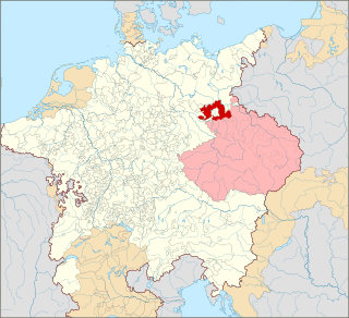
The Neustadt O.S. district was a Prussian district in Upper Silesia from 1743 to 1945. Its capital was the city of Neustadt (Prudnik). Its territory corresponded roughly to the present-day Prudnik County in the Opole Voivodeship in Poland.

<span class="mw-page-title-main">Sławięcice</span> District of Kędzierzyn-Koźle, Poland

Sławięcice is a district of Kędzierzyn-Koźle, Opole Voivodeship, Poland, located in the eastern part of the city.

References

  1. Leksykon Polactwa w Niemczech (in Polish). Opole: Związek Polaków w Niemczech. 1939. p. 392.
  2. Chisholm, Hugh, ed. (1911). "Cosel"  . Encyclopædia Britannica . Vol. 7 (11th ed.). Cambridge University Press. p. 213.
  3. Leksykon Polactwa w Niemczech. p. 35.
  4. Cygański, Mirosław (1984). "Hitlerowskie prześladowania przywódców i aktywu Związków Polaków w Niemczech w latach 1939-1945". Przegląd Zachodni (in Polish) (4): 24.
  5. "Working Parties". Lamsdorf.com. Archived from the original on 29 October 2020. Retrieved 22 May 2021.
  6. "The Death Marches". Sub Camps of Auschwitz. Retrieved 27 June 2021.
  7. "6,000 WWII-era bomb craters mapped in Poland". Live Science. 17 March 2021.
  8. Kulczycki, J.J. (2016). Belonging to the Nation: Inclusion and Exclusion in the Polish-German Borderlands, 1939–1951. Harvard University Press. p. 250. ISBN   978-0-674-96953-7 . Retrieved 2023-08-11.

Commons-logo.svg Media related to Kędzierzyn-Koźle at Wikimedia Commons