
Borneo is the third-largest island in the world, with an area of 748,168 km2 (288,869 sq mi). Situated at the geographic centre of Maritime Southeast Asia, it is one of the Greater Sunda Islands, located north of Java, west of Sulawesi, and east of Sumatra.
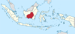
Central Kalimantan is a province of Indonesia. It is one of five provinces in Kalimantan, the Indonesian part of Borneo. It is bordered by West Kalimantan to the west, South Kalimantan and East Kalimantan to the east, Java Sea to the south and is separated narrowly from North Kalimantan and Malaysia by East Kalimantan's Mahakam Ulu Regency. Its provincial capital is Palangka Raya and in 2010 its population was over 2.2 million, while the 2020 Census showed a total of almost 2.67 million; the official estimate as at mid 2022 was 2,741,075.
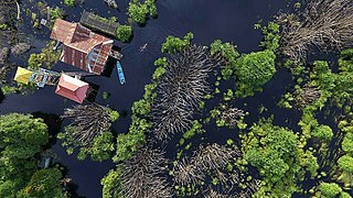
Peat swamp forests are tropical moist forests where waterlogged soil prevents dead leaves and wood from fully decomposing. Over time, this creates a thick layer of acidic peat. Large areas of these forests are being logged at high rates.

The Borneo peat swamp forests ecoregion, within the tropical and subtropical moist broadleaf forests biome, are on the island of Borneo, which is divided between Brunei, Indonesia and Malaysia.

The Bornean orangutan is a species of orangutan endemic to the island of Borneo. Together with the Sumatran orangutan and Tapanuli orangutan, it belongs to the only genus of great apes native to Asia. It is the largest of the three species of orangutans. Like the other great apes, orangutans are highly intelligent, displaying tool use and distinct cultural patterns in the wild. Orangutans share approximately 97% of their DNA with humans. Also called mias by the local population, the Bornean orangutan is a critically endangered species, with deforestation, palm oil plantations, and hunting posing a serious threat to its continued existence.
Kumai is a port in Central Kalimantan province in Indonesia, on the island of Borneo. It lies on the Kumai River.

Hose's langur is a species of primate in the family Cercopithecidae endemic to the island of Borneo, including Brunei, Kalimantan (Indonesia), and East Malaysia. Its natural habitat is subtropical or tropical dry forests. It is threatened by habitat loss. It was first identified in Kutai National Park and Sangkulirang Peninsula, East Kalimantan, Indonesia, in 1985.

The acuminate horseshoe bat is a species of bat in the family Rhinolophidae. It is found in Southeast Asia. It lives in forests and urban areas.

The Mega Rice Project was initiated in 1996 in the southern sections of Kalimantan, the Indonesian section of Borneo. The goal was to turn one million hectares of unproductive and sparsely populated peat swamp forest into rice paddies in an effort to alleviate Indonesia's growing food shortage. The government made a large investment in constructing irrigation canals and removing trees. The project did not succeed, and was eventually abandoned after causing considerable damage to the environment.
Sabangau National Park is a national park in Central Kalimantan, a province of Indonesia in Kalimantan, the Indonesian part of the island of Borneo established in 2004. Between 1980 and 1995 the site was a massive logging concessions area. After 1995, the park became a site for illegal logging, which resulted in up to 85 percent of the 568,700-hectare total park area being destroyed. By 2012, less than 1 percent of the park's total area has been reforested and at the current rate, it will take several centuries to restore it to its pre-logged state.

The Borneo Orangutan Survival (BOS) Foundation is an Indonesian non-profit non-governmental organization founded by Dr. Willie Smits in 1991 and dedicated to the conservation of the endangered Bornean orangutan and its habitat through the involvement of local people. It is audited by an external auditor company and operates under the formal agreement with the Indonesian Ministry of Forestry to conserve and rehabilitate orangutans. The BOS Foundation manages orangutan rescue, rehabilitation and re-introduction programmes in East and Central Kalimantan. With more than 400 orangutans in its care and employing more than 440 people at a 10 sites BOS Foundation is the biggest non-human primate conservation non-governmental organization worldwide. Nyaru Menteng and Samboja Lestari are the BOS Foundation sites that have received most extensive media coverage. Nyaru Menteng, founded by Lone Drøscher Nielsen, has been the subject of a number of TV series, including Orangutan Diary, Orangutan Island and the series Orangutan Jungle School, airing since 2018.

Tanjung Puting National Park is a national park in Indonesia located in the southeast part of West Kotawaringin Regency in the Indonesian province of Central Kalimantan. The nearest main town is the capital of the Regency, Pangkalan Bun. The park is famous for its orangutan conservation.

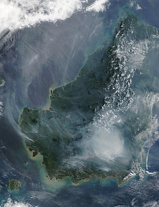
Deforestation in Borneo has taken place on an industrial scale since the 1960s. Borneo, the third largest island in the world, divided between Indonesia, Malaysia and Brunei, was once covered by dense tropical and subtropical rainforests.
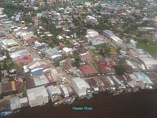
Pawan River is a major river of West Kalimantan, Indonesia. It has a length of 197 kilometres (122 mi). Tributaries include the Keriau River.
Lamandau River is a river of Kalimantan, southern-central Borneo, Indonesia. Downstream after passing the village of Nanga Bulik it becomes the Kotawaringin River.

The Rimba Raya Biodiversity Reserve, nearly the size of Singapore, consists of 64,000 hectares of bio-diverse tropical peat swamp forest that contain as much as 1,000 plant and animal species per hectare and is one of the most highly endangered ecosystems on the planet. The project area and ongoing initiatives focus on environmental conservation, community outreach, and climate control. Rimba Raya is home to one of the few remaining relic populations of wild orangutans and is the largest privately funded orangutan reserve in the world. The area is also one of the world’s largest repositories of carbon. Rimba Raya is the world’s largest REDD+ project -Reduced Emissions from (Avoided) Deforestation and Degradation (REDD). The project developer, InfiniteEARTH, is an industry pioneer, delivering the world’s first REDD methodology in 2009.
Sekonyer is a river in southern Borneo, Central Kalimantan province, Indonesia, about 700 km northeast of the capital Jakarta.

Durio oxleyanus is a perennial plant species of tree in the family Malvaceae. It was once placed in the family Bombacaceae.
Tudal Hill, is one of the major hills shared between Mukim Amo, Temburong District of Brunei and Limbang Division, Sarawak of Malaysia.

