Martapura River

Last updated

Martapura River
Sungai Banjar Kecil, Sungai Kayutangi
Sungai Cina, Sungai Tatas, Soengai Martapoera
Banks of Martapura River, South Kalimantan, 2018-07-28 01.jpg
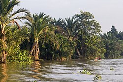
Martapura River outside Banjarmasin
Native nameSungai Martapura (Indonesian)
Location
Country Indonesia
Province South Kalimantan
Physical characteristics
Source 
  location Martapura, Banjar Regency
Mouth Barito River

The Martapura River (Indonesian : Sungai Martapura) is a river in southeast Borneo, Indonesia. [1] [2] It is a tributary of the Barito River. Other names for the river are Banjar Kecil River [3] [4] [5] [6] or Kayutangi River and due to many activities of Chinese merchants in the past in the downstream area also called China River. [7] [8] [9] It merges with the Barito River in Banjarmasin, flowing from the source in Martapura, Banjar Regency, South Kalimantan. [10]

Contents

Etymology

The river name is taken from the city of Martapura, which was the capital of Banjar Kingdom in around 1630, specifically in the area of Kayu Tangi (hence also the name "Kayutangi River"). [11] Another name is "Tatas River" (Indonesian: Sungai Tatas), pointing to the delta Tatas, which in 1787 was acquired by the Dutch East India Company (now the downtown of modern-day Banjarmasin). [12]

Hydrology

The watershed area (Indonesian: daerah aliran sungai) of Martapura is 453.88 square kilometers (175.24 sq mi), with the main river length of 36,566 meters (119,967 feet), and with all tributaries has a total length of 375.91 kilometers (233.58 mi), giving a river density level of 0.828 km/km2 (1.333 mi/sq mi). [13] The elevation difference between the upstream and downstream is 8.00 meters (26.25 ft), yielding a river gradient of 0.022%. [13] The upstream area is the Riam Kanan Dam. [13]

Geography

The river flows in the southeast area of Borneo with a predominantly tropical rainforest climate (designated as Af in the Köppen-Geiger climate classification). [14] The annual average temperature in the area is 25 °C (77 °F). The warmest month is October, when the average temperature is around 28 °C (82 °F), and the coldest is July, at 24 °C (75 °F). [15] The average annual rainfall is 2,767 millimeters (108.9 in). The wettest month is February, with an average of 366-millimeter (14.4 in) rainfall, and the driest is September, with a 75-millimeter (3.0 in) rainfall. [16]

See also

Related Research Articles

<span class="mw-page-title-main">South Kalimantan</span> Province in Indonesia

South Kalimantan is a province of Indonesia. It is the smallest province in Kalimantan, the Indonesian territory of Borneo. The provincial capital was Banjarmasin until 15 February 2022 when it was legally moved to Banjarbaru. The population of South Kalimantan was recorded at just over 3.625 million people at the 2010 Census, and at 4.07 million at the 2020 Census. The official estimate as at mid 2022 was 4,182,080. One of the five Indonesian provinces in Kalimantan, it is bordered by the Makassar Strait in the east, Central Kalimantan in the west and north, the Java Sea in the south, and East Kalimantan in the north. The province also includes the island of Pulau Laut, located off the eastern coast of Kalimantan. The province is divided into 11 regencies and 2 cities. South Kalimantan is the traditional homeland of the Banjar people, although some parts of East Kalimantan and Central Kalimantan are also included in this criteria. Nevertheless, South Kalimantan, especially the former capital city Banjarmasin has always been the cultural capital of Banjarese culture. Many Banjarese have migrated to other parts of Indonesia, as well as neighbouring countries such as Singapore and Malaysia. In addition, other ethnic groups also inhabit the province, such as several groups of the Dayaks, who mostly live in the interior part of the province, as well as the Javanese, who mostly migrated from Java due to the Transmigration program which dated from the Dutch colonial era.It is one of the provinces in Indonesia that has a larger population than Mongolia.

<span class="mw-page-title-main">Banjarmasin</span> City in South Kalimantan, Indonesia

Banjarmasin is a city in South Kalimantan, Indonesia. It was the capital of the province until 15 February 2022. The city is located on a delta island near the junction of the Barito and Martapura rivers. Historically the centre of the Banjarese culture, and the capital of the Sultanate of Banjar, it is the biggest city in South Kalimantan and one of the main cities of Kalimantan. The city covers an area of 98.46 km2 (38.02 sq mi) and had a population of 625,481 as of the 2010 Census and 657,663 as of the 2020 Census; the official estimate as of mid 2022 was 667,489. Greater Banjarmasin, also known as Banjarbakula, is an urban agglomeration of around two million people covering an area of 8,136 km2 (3,141 sq mi), which includes Banjarbaru city and parts of Banjar Regency, Barito Kuala Regency, and Tanah Laut Regency, and accounts for almost half of the province's population. It is the third most populous city on the island of Borneo.

<i>Hikayat Banjar</i>

The Hikayat Banjar is the chronicle of Banjarmasin, Indonesia. This text, also called the History of Lambung Mangkurat, contains the history of the kings of Banjar and of Kotawaringin in southeast and south Borneo respectively.

<span class="mw-page-title-main">Banjarbaru</span> City and capital of South Kalimantan, Indonesia

Banjarbaru is the capital city of South Kalimantan, one of the provinces in Indonesia. It is located 35 km (22 mi) southeast of Banjarmasin, the largest city of the province. The city had a population of 199,627 as of the 2010 Census, and 253,442 at the 2020 Census, and the official population estimate was 265,575. The town of Martapura lies immediately to the north of Banjarbaru, and in effect constitutes an extension of the city. The second largest city in the province after Banjarmasin, it is also part of Banjarbakula metropolitan area.

<span class="mw-page-title-main">Banjar people</span> Ethnic group native to South Kalimantan

The Banjar or Banjarese are an Austronesian ethnic group native to the Banjar regions in the southeastern Kalimantan regions of Indonesia. Nowadays, Banjarese diaspora can be found in neighbouring Banjar regions as well; including Kotabaru Regency, the southeastern regions of Central Kalimantan, southernmost regions of East Kalimantan, and some provinces of Indonesia in general. The Banjarese diaspora community also can be found in neighbouring countries of Indonesia, such as Brunei, Malaysia, and Singapore.

<span class="mw-page-title-main">Barito River</span> Major river in Kalimantan (Indonesian Borneo)

The Barito River is the second longest river in Borneo after the Kapuas River with a total length of 1,090 km (680 mi) and a drainage basin of 81,675 square kilometers (31,535 sq mi) in South Kalimantan, Indonesia. It originates in the Muller Mountain Range, from where it flows southward into the Java Sea. Its most important affluent is the Martapura River, and it passes through the city of Banjarmasin.

The Lawa River is a river in East Kalimantan province, Borneo island, Indonesia, about 150 kilometers northwest of Balikpapan. It is a branch of the Mahakam River in eastern Borneo, which is situated entirely within the Kutai Barat, and flows into the Mahakam approximately 200 kilometers (120 mi) upstream from Samarinda. The indigenous communities of Lotaq and Mejaun are situated near its source.

<span class="mw-page-title-main">Bakumpai people</span> Ethnic group in Indonesia

Bakumpai or Baraki are indigenous people of Borneo and are considered as a sub-ethnic group of the Dayak Ngaju people group with Islamic background. The Bakumpai people first occupy along the Barito riverbanks in South Kalimantan and Central Kalimantan, from Marabahan to Puruk Cahu, Murung Raya Regency. The Bakumpai people first appeared as a newly recognized people group in census 2000 and were made up of 7.51% of Central Kalimantan population, which before this the Bakumpai people were considered as part of the Dayak people in a 1930 census.

<span class="mw-page-title-main">Sultanate of Banjar</span> Former sultanate in South Kalimantan

Sultanate of Banjar or Sultanate of Banjarmasin was a sultanate located in what is today the South Kalimantan province of Indonesia. For most of its history, its capital was at Banjarmasin.

The Telen River is a river in East Kalimantan, Borneo island, Indonesia, about 110 kilometers north of the provincial capital Samarinda. It is a tributary of the Mahakam River.

The Belayan River is a river of Borneo, Indonesia, 1300 km northeast of the capital Jakarta. It is a tributary of the Mahakam River.

The Negara River is a river of Borneo, Indonesia. It flows in the southeast region of the island, within the Negara District, province of South Kalimantan. It is the second longest river in the province after the Barito River, which the Negara River flows into.

<span class="mw-page-title-main">Mandiri River</span> River in Indonesia

Mandiri River is a river in southwestern Java of West Java province, Indonesia. It flows mainly in the Sukabumi Regency.

<span class="mw-page-title-main">Hasan Basry</span> Indonesian revolutionary

Hasan Basry was a military general, Indonesian nationalist leader, and was a key figure in the liberation of Kalimantan from Dutch rule. During the Indonesian National Revolution, he acted as the military representative of the Indonesian army in Kalimantan and led a guerilla war against the Linggadjati Agreement. He was a key figure behind the 17 May Proclamation which rallied Kalimantan natives against Dutch rule in 1949. He was declared a National Hero of Indonesia in 2001.

<span class="mw-page-title-main">Kodam VI/Mulawarman</span> Military unit

Kodam VI/Mulawarman is a military territorial command of the Indonesian Army. It has been in active service as the local division for the provinces of North Kalimantan, East Kalimantan and South Kalimantan.

<span class="mw-page-title-main">Tabalong River</span> River in Kalimantan (Indonesian Borneo)

The Tabalong River is a river traversing Tabalong Regency, in the province of South Kalimantan, Indonesia. The river flows into the Negara River. It is a confluence of two tributaries: the Left Tabalong and Right Tabalong rivers.

<span class="mw-page-title-main">Jukung tambangan</span>

Jukung tambangan is a traditional boat made by the Banjar people of South Kalimantan. They are mainly used for riverine transportation. It is already present at least since mid-18th century. They were not seen anymore in Banjarmasin ca. 1950s and around the 1970s on the Nagara River, Hulu Sungai Selatan Regency.

<span class="mw-page-title-main">Port of Trisakti</span> Port in Indonesia

Port of Trisakti is a seaport in Banjarmasin in South Kalimantan, Indonesia. It is one of the major ports in Borneo. The port is located on the Southwest of the Tatas Island, which is between the intersection of Barito River and Martapura River, with which it is connected to the Java Sea.

<span class="mw-page-title-main">Kalimantan Physical Revolution</span>

The Kalimantan Physical Revolution was an armed conflict between Indonesian nationalists in and pro-Dutch forces in Dutch Borneo following the end of the Japanese occupation of the Dutch East Indies and the 1945 Proclamation of Indonesian Independence by Sukarno and which lasted until the Dutch withdrew from most of Indonesia in 1949. It can be considered a regional conflict in the larger Indonesian National Revolution. After the surrender of the Japanese at the end of World War II, allied forces took control of the Dutch East Indies, including Dutch Borneo. The return of Dutch authorities however, was rejected by majority of native population, including in Borneo, resulting in various regional armed conflicts between Royal Netherlands East Indies Army and Indonesian nationalist forces. Allied military forces in Borneo were in a strong position after an early conflict in August 1945, and were able to pacify local nationalist uprisings and impose a blockade to prevent military aid and exchange in personnel from nationalist strongholds in Java and Sumatra. Later, nationalists with connections to Borneo were able to breach tofhe military blockade to provide information revolutionary events in Java and Sumatra, declaring Kalimantan as inseparable part of the new Indonesian republic.

Negara Dipa was a Hindu kingdom in South Kalimantan that appears in Hikayat Banjar. It was located in Amuntai near modern-day Tabasan. It was also the predecessor of Negara Daha and Banjar Sultanate.

References

  1. Rand McNally, The New International Atlas, 1993.
  2. Sungai Martapura - Geonames.org.
  3. Müller, Salomon (1857). Reizen en onderzoekingen in den Indischen archipel, gedaan op last der nederlandsche indische regering, tusschen de jaren 1828 en 1836: Nieuwe uitgave, met verbeteringen (in Dutch). Amsterdam: Frederik Muller.
  4. "Annette Delarbre". Tijdschrift voor Nederlandsch Indië (in Dutch). Vol. 1, no. 1. 1838. p. 6.
  5. "Eenige reizen in de Binnenlanden van dit Eiland, door eenen Ambtenaar van het Gouvernement, in het jaar 1824". Tijdschrift voor Nederlandsch-Indië (in Dutch). Vol. 1, no. 2. 1838. p. 6.
  6. Buddingh, Steven Adriaan (1861). Neêrlands-Oost-Indië: Reizen over Java, Madura, Makasser, Saleijer, Bima, Menado, Sangier-eilanden, Talau-eilanden, Ternate, Batjan, Gilolo en omliggende eilanden, Banda-eilanden, Amboina, Haroekoe, Saparoea, Noussalaut, Zuidkust van Ceram, Boeroe, Boano, Banka, Palembang, Riouw, Benkoelen, Sumatra's West-Kust, Floris, Timor, Rotty, Borneo's West-Kust, en Borneo's Zuid- en Oost-Kust; gedaan gedurende het tijdvak van 1852-1857 (in Dutch). M. Wijt. pp.  442. de kleine Banjersche rivier.
  7. James Cook, A collection of voyages round the world: performed by royal authority. Containing a complete historical account of Captain Cook's first, second, third and last voyages, undertaken for making new discoveries, &c. ... To which are added genuine narratives of other voyages of discovery round the ... , Printed for A. Millar, W. Law, and R. Cater, 1790
  8. Salmon, Thomas (1744). Modern history or, the present state of all nations. Describing their respective situations, persons, habits, and buildings, manners, laws and customs ... plants, animals, and minerals. Vol. 1. London: Printed for T. Longman [et al.] via Internet Archive.
  9. https://atlantisjavasea.files.wordpress.com/2015/09/1726-herman-moll.jpg [ bare URL image file ]
  10. Eriza Islakul Ulmi, Nilna Amal. Kajian Ekohidraulik Sungai Martapura. Program Studi Teknik Sipil, Fakultas Teknik, Universitas Lambung Mangkurat, Banjarbaru.
  11. (in Indonesian) Mohamad Idwar Saleh, Banjarmasih: sejarah singkat mengenai bangkit dan berkembangnya kota Banjarmasin serta wilayah sekitarnya sampai dengan tahun 1950, Museum Negeri Lambung Mangkurat Propinsi Kalimantan Selatan, Direktorat Permuseuman, Direktorat Jenderal Kebudayaan, Departemen Pendidikan dan Kebudayaan, 1982
  12. James Cook, A collection of voyages round the world: performed by royal authority. Containing a complete historical account of Captain Cook's first, second, third and last voyages, undertaken for making new discoveries, &c. ... To which are added genuine narratives of other voyages of discovery round the ... , Printed for A. Millar, W. Law, and R. Cater, 1790
  13. 1 2 3 Sobatnu, Ferry; Irawan, Faris Ade; Salim, Agus. Identifikasi dan Pemetaan Morfometri Daerah Aliran Sungai Martapura menggunakan teknologi GIS. Jurnal Gradasi Teknik Sipil. 2017. Vol 1, No. 2. Halaman 45-52.
  14. Peel, M C; Finlayson, B L; McMahon, T A (2007). "Updated world map of the Köppen-Geiger climate classification". Hydrology and Earth System Sciences. 11 (5): 1633–1644. Bibcode:2007HESS...11.1633P. doi: 10.5194/hess-11-1633-2007 .
  15. "NASA Earth Observations Data Set Index". NASA. 30 January 2016.
  16. "NASA Earth Observations: Rainfall (1 month - TRMM)". NASA/Tropical Rainfall Monitoring Mission. 30 January 2016.

3°17′31″S114°34′52″E / 3.2919°S 114.5811°E / -3.2919; 114.5811

Commons-logo.svg Media related to Martapura River at Wikimedia Commons