Sesayap River is a river in Borneo island, flowing in North Kalimantan Province, Indonesia. It forms a delta which has islands including Bunyu and Tarakan Island.
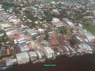
Pawan River is a major river of West Kalimantan, Indonesia. It has a length of 197 kilometres (122 mi). Tributaries include the Keriau River.
Sekayam River is a river of Borneo, West Kalimantan province, Indonesia. It is a tributary of the Kapuas River. The Public Forest System Utility Program has a scheme on the river aimed at reducing the level of mercury content absorbed by humans.

Melawi River is a river of north-western Borneo, Indonesia, about 900 km northeast of the capital Jakarta. It is a tributary of the Kapuas River.
Arut River is a river in the province of Kalimantan Tengah, island of Borneo, Indonesia, about 700 km northeast of the capital Jakarta. It is a tributary of the Lamandau River. The river flows through the north side of Pangkalan Bun town.

Pembuang River or Seruyan River is a river of Borneo, Indonesia. The river has its source near Bikit Tikung in the Schwaner Mountain Range. The eastern side of the river contains dense forest down to Sembulu (Belajau) lakes and is said to be a major habitat of the orangutan. Pembuang means "place of rejection".
The Sampit River or Mentaya River is a river of Central Kalimantan, Borneo, Indonesia. The river takes its name from the town of Sampit which lies on the river not far from the Java Sea. Near the mouth of the river is a noted beach park named "Pandaran Beach". The Sampit flows into the Java Sea at 2°58′20″S113°2′23″E.

Mendawai River or Katingan River is a river of Borneo, it is located in Central Kalimantan, Indonesia. With a total length of 616 km (383 mi). The longhouses of the Pendahara are located along the river in its upper course. The river has its source in the Schwaner Mountain Range.
The Telen River is a river in East Kalimantan, Borneo island, Indonesia, about 110 kilometers north of the provincial capital Samarinda. It is a tributary of the Mahakam River.
The Sembakung River is a river in Borneo that flows from Sabah, Malaysia to North Kalimantan, Indonesia, about 1600 km northeast of the capital Jakarta.
The Kelai River is a river of Borneo, in the province of East Kalimantan, Indonesia, about 300 kilometers (190 mi) north the provincial capital Samarinda. It is a tributary of the Berau River.
The Bahau River is a river in North Kalimantan, Indonesia, about 1400 km northeast of the capital Jakarta.
Serang River is a river in northern Central Java, Indonesia, about 400 km east of the capital Jakarta. The largest tributary is Lusi River, which discharges into Serang River after passing the city of Purwodadi.
Lusi River is a river in northern Central Java, Indonesia, about 400 km east of the capital Jakarta. It is a tributary of the Serang River, meeting after passing the city of Purwodadi.
The Jelai-Bila River is a river of Central Kalimantan, Indonesia, about 600 km northeast of the capital Jakarta. Much of the land between the Lamandau River and the Jelai-Bila River is developed by agriculture.
The Kaso River is a stream in the Indonesian part of the island of Borneo, about 1100 km northeast of the Indonesian capital Jakarta. One of its tributaries is the Seputan River. The Kaso flows into the Mahakam River. In 1889, Tromp reported three villages of Bukat people on the Kaso. In fact the villages were on the Penane River, a tributary of the Kacu at Long Mecai. The semi-nomadic Seputan people also live on the Kacu at times.
The Tuntang is a major river of northern Central Java, Indonesia, about 400 km east of the capital Jakarta. It connects Lake Rawa Pening to the Java Sea, east of Semarang. There is a hydroelectric powerstation on the river near the lake.
Sekonyer is a river in southern Borneo, Central Kalimantan province, Indonesia, about 700 km northeast of the capital Jakarta.

The Tabalong River is a river traversing Tabalong Regency, in the province of South Kalimantan, Indonesia. The river flows into the Negara River. It is a confluence of two tributaries: the Left Tabalong and Right Tabalong rivers.
Sambas River, or specifically referred to Big Sambas River, is a river in Sambas Regency, West Kalimantan, Indonesia. The upstream is located in Kabupaten Bengkayang, flowing through the city of Sambas, continuing to Pemangkat where it discharges into South China Sea.

