
The Saugeen River is located in southern Ontario, Canada. The river begins in the Osprey Wetland Conservation Lands and flows generally north-west about 160 kilometres (99 mi) before exiting into Lake Huron. The river is navigable for some distance, and was once an important barge route. Today the river is best known for its fishing and as a canoe route.

The Sava is a river in Central and Southeast Europe, a right-bank and the longest tributary of the Danube. It flows through Slovenia, Croatia and along its border with Bosnia and Herzegovina, and finally through Serbia, feeding into the Danube in its capital, Belgrade. The Sava forms the main northern limit of the Balkan Peninsula, and the southern edge of the Pannonian Plain.

The Neretva, also known as Narenta, is one of the largest rivers of the eastern part of the Adriatic basin. Four hydroelectric power plants with large dams provide flood protection, electricity and water storage. The Neretva is recognized for its natural environment and diverse landscapes.

Odra is a river in central Croatia. It is 83 km (52 mi) long and its basin covers an area of 604 km2 (233 sq mi). Its source is in the Žumberak mountain, southwest of Zagreb. It flows eastwards, passes south of Velika Gorica, then turns south-east, more or less parallel to the river Sava. It flows into the river Kupa near Odra Sisačka, just northeast of Sisak, also just before the Kupa joins the river Sava.

The Kupa or Kolpa river, a right tributary of the Sava, forms a natural border between north-west Croatia and southeast Slovenia. It is 297 kilometres long, with a length of 118 km (73 mi) serving as the border between Croatia and Slovenia and the rest located in Croatia.
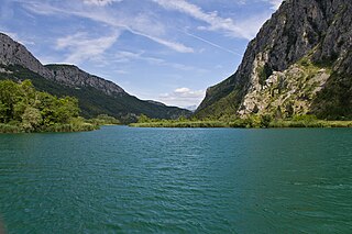
Cetina is a river in southern Croatia. It has a length of 101 km (63 mi) and its basin covers an area of 1,463 km2 (565 sq mi). From its source, Cetina descends from an elevation of 385 metres (1,263 ft) above sea level to the Adriatic Sea. It is the most water-rich river in Dalmatia.

The Korana is a river in central Croatia and west Bosnia and Herzegovina. The river has a total length of 138.6 km (86.1 mi) and watershed area of 2,301.5 km2 (888.6 sq mi).

The Bosut is a river in the Syrmia region of eastern Croatia and northwestern Serbia, a 186 km long left tributary of the Sava river. Slow and meandering, it originates from the confluence of Biđ and Berava rivers south of the city of Vinkovci, the only major city on its course, and then turns southeast. Near Lipovac it receives its major tributary Spačva, and then enters Serbia near Batrovci. In its lower course, Bosut flows through a forested area in the Spačva region. The river is generally known for its abundance of fish.
The Dobra is a river located mostly in the Karlovac County in the Republic of Croatia. It is 104.2 kilometres (64.7 mi) long and its basin covers an area of 1,428 square kilometres (551 sq mi). Its name is the feminine form of the Croatian adjective meaning "good" but it is over simplistic folk etymology. The river name probably comes from the Celtic transl. cel – transl. dubrum, dubron meaning ‘water’, Illyrian δυβρις ‘deep’ or Old Slavonic dъbrь also ‘deep’ or ‘valley’.
The Čabranka is a small river on the border between Slovenia and Croatia. It is 17.5 kilometres (10.9 mi) long and is a left tributary of the Kupa River. Its source is just west of the settlement of Podplanina in the Municipality of Loški Potok in southern Slovenia and just north of the Croatian village of Čabar, from which it gets its name. It joins the Kupa at Osilnica.

Slabinja is a village in the Sisak-Moslavina County in the central part of Croatia. It is in the Una Valley near the border with Bosnia and Herzegovina, 12.6 kilometres (7.8 mi) southeast of the town of Hrvatska Kostajnica, 9.7 kilometres (6 mi) northwest of the village of Hrvatska Dubica, and 106 kilometres (66 mi) southeast of Croatian capital Zagreb, at the south fringe of the Banovina region. Slabinja is a dormitory village with a resident population of just over 250 people.

The Lonja is a river in central Croatia, a left tributary of the Sava. It is 49 kilometres (30 mi) long and its basin covers an area of 4,259 square kilometres (1,644 sq mi).

The Bednja is a river in northern Croatia, a right tributary of the Drava. It is 133 kilometres (83 mi) long and its basin covers an area of 966 square kilometres (373 sq mi). The Bednja rises in the mountainous forested areas near Macelj in northern Croatia, west of Trakošćan, where it also forms a 0.2 km2 (0.077 sq mi) lake at 255 m.a.s.l. It flows towards the southeast until turning east near Bednja, meandering south at Novi Marof, returning to its eastward course shortly thereafter, and then turning northeast toward Ludbreg. It flows into the Drava River north of Mali Bukovec, at 46.303333°N 16.756389°E.

Glina is a river in central Croatia and Bosnia and Herzegovina, a right tributary of Kupa. It is 112 kilometres (70 mi) long and its basin covers an area of 1,427 square kilometres (551 sq mi).

Orljava is a river in Slavonia, eastern Croatia, a left tributary of Sava. It is 87.6 kilometres (54.4 mi) long and its basin covers an area of 1,618 square kilometres (625 sq mi).

Sunja is a river in central Croatia, a right tributary of Sava. It is 69 kilometres (43 mi) long and its basin covers an area of 462 square kilometres (178 sq mi).

The Ilova is a river in central Croatia, a left tributary of the Sava. It is 104.6 kilometres (65.0 mi) long and its basin covers an area of 1,796 square kilometres (693 sq mi).
Glogovnica is a river in central Croatia, a right tributary of Česma. It is 64.5 kilometres (40.1 mi) long.

Plitvica is a river in northern Croatia, a right tributary of Drava. It is 65 kilometres (40 mi) long and its basin covers an area of 272 square kilometres (105 sq mi).

Karašica or Baranjska Karašica or Karassó is a river in southern Hungary and eastern Croatia. It is 81 kilometres (50 mi) long, of which 30.46 km (18.93 mi) in Croatia. Its basin covers a total of 910 km2 (350 sq mi).

