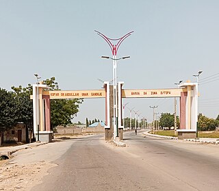
Ungoggo is a Local Government Area in Kano State, Nigeria. Its Secretariat are in the town of Ungogo to the north of the city of Kano.
Langtang South is a Local Government Area in Plateau State, Nigeria. Its headquarters are in the town of Mabudi.
Shelleng is a Local Government Area (LGA) of Adamawa State, North-east Nigeria.

Askira/Uba is a Local Government Area of Borno State, Nigeria. Its headquarters are in the town of Askira.
Danbatta is a Local Government Area in Kano State, Nigeria. It is located about 49 miles north of Kano city at the Northern border of Kano state with Jigawa state. It has headquarters at Danbatta town, located on the A2 highway.

Gezawa is a Local Government Area in Kano State, Nigeria. Gezawa Local Government Area administrative headquarters is in the town of Gezawa with its area council made up of Jogana, Gawo, Zango, Tumbau, Wangara, Sarain-Gezawa, Babawa, Ketatwa and Tsamiya-Dabba. It has an area of 340 km2 and a population of 282,069 at the 2006 census. Hausa and Fulani ethnic groups make up the majority of the local population. The majority religion practiced in the region is Islam, and the languages spoken there are Fufulde and Hausa.
Bagwai is a local government area in Kano State, Nigeria. Its headquarters is in the town of Bagwai.

Dawakin Tofa is a Local Government Area in Kano State, Nigeria. Its headquarters are in the town of Dawakin Tofa and It includes a number of cities and villages, such as Alajawa, Bagari, Bankaura, Dandalama, Jobenkun, Kaleku, Rumi and Yelwa. Hausa and Fulani ethnic divides being the two most notable tribes. The Hausa and Fufulde languages are widely spoken in the region, and Islam is the most commonly practiced religion there. The Dawakin Tofa General Hospital and the Dawakin Tofa Science College are well-known structures in Dawakin Tofa.
Kumbotso is a Local Government Area in Kano State, Nigeria. Its headquarters are in the town of Kumbotso. It has an area of 158 km2 and a population of 409,500 based on the 2016 population projection census.
Madobi is a Local Government Area in Kano State, Nigeria. Its headquarters are in the town of Madobi.
Kibiya is a Local Government Area in Kano State, Nigeria. Its headquarters are in the town of Kibiya. The traditional ruler of Kibiya is former Comptroller General of Immigration Senator Usman Kibiya Umar.
Bunkure is a Local Government Area in Kano State, Nigeria. Its headquarters are in the town of Bunkure.
Garko is a Local Government Area in Kano State, Nigeria. Its headquarters are in the town of Garko on the A237 highway.
Ajingi is a Local Government Area in Kano State, Nigeria. Its headquarters are in the town of Ajingi.
Kiru is a Local Government Area in Kano State, Nigeria. Its headquarters are in the town of Kiru.
Birnin Magaji/Kiyaw is a Local Government Area in Zamfara State, Nigeria. Its headquarters are in the town of Birnin Magaji in the north of the LGA at12°33′00″N6°49′00″E. The LGA is also named from the town of Kiyaw to the south.
Zing is a Local Government Area in Taraba State, Nigeria. Its headquarters are in the town of Zing.
Sabon Birni is a Local Government Area in Sokoto State, Nigeria. Its headquarters are in the town of Sabon Birni.
Gwadabawa is a Local Government Area in Sokoto State, Nigeria. Its headquarters are in the town of Gwadabawa on the A1 highway. It comprises Gwadabawa, Salame, Chimola and Asara districts
Barkin Ladi is a Local Government Area in Plateau State, Nigeria. Its headquarters are in the town of Gwol at 9°32′00″N8°54′00″E.


