
Bulgarian Beach is a coast in the north part of Hurd Peninsula, eastern Livingston Island, extending 2.3 km from Hespérides Point to the southwest to Perunika Glacier to the northeast, and forming the southeast coast of Emona Anchorage.

Catalunyan Saddle is a saddle of 1260 m height in the Friesland Ridge of the Tangra Mountains on Livingston Island, in the South Shetland Islands. The saddle is bounded by Lyaskovets Peak to the east and by Presian Ridge to the west. The saddle was named in honour of the Catalans Francesc Sàbat and Jorge Enrique from Juan Carlos I Base who established the first route via the saddle to Mount Friesland on 30 December 1991.

Dimov Gate is a 300 m wide ice-covered pass in Antarctica, located in eastern Livingston Island in the South Shetland Islands, Antarctica and bounded by Rayna Knyaginya Peak in Bowles Ridge to the southeast and by Hemus Peak to the northwest. The pass separates the glacial catchments of Kaliakra Glacier, and the tributary glacier draining the area between Hemus Peak and Bowles West Peak and flowing west-southwestwards into Perunika Glacier. It affords overland access from Perunika Glacier to the northern slopes of Bowles Ridge and to upper Kaliakra Glacier.

Ioannes Paulus II Peninsula is an ice-covered peninsula on the north coast of Livingston Island in the South Shetland Islands, Antarctica that is bounded by Hero Bay to the east and Barclay Bay to the west. It extends 13 km in length in north–south direction and is 8 km wide. Its north extremity is formed by the ice-free Cape Shirreff, an area visited by early 19th century sealers. The peninsula's interior is occupied by Oryahovo Heights.

Maritsa Peak rises to 560 m in eastern Bowles Ridge on Livingston Island in the South Shetland Islands, Antarctica. It has precipitous rocky south slopes, and is situated on the west side of Pirdop Gate, surmounting Huron Glacier to the south and Struma Glacier to the north. The peak is "named after the Maritsa River in Bulgaria."
Orpheus Gate, also Orpheus Pass, is the 548 m high and 380 m wide pass in eastern Livingston Island in the South Shetland Islands, Antarctica, bounded by Pliska Ridge to the southeast and Burdick Ridge to the northwest, Huntress Glacier to the southwest and Perunika Glacier to the northeast.
Rezen Knoll is a knoll rising to 433 m in eastern Livingston Island in the South Shetland Islands, Antarctica. The knoll is bounded to the east, north and west by Perunika Glacier, and linked to Burdick Ridge by Rezen Saddle. The feature is 250 m wide, extending 500 m in east-west direction. Composed of lavas, with precipitous slopes except to the east. Partly ice-free height and western and northern slopes.
Rezen Saddle is a geographical feature on Livingston Island in the South Shetland Islands, Antarctica. The 600 m long horseshoe-shaped flat saddle of elevation 420 m lies between Rezen Knoll and Burdick Ridge in eastern Livingston Island, affording overland access from Balkan Snowfield to upper Perunika Glacier and Bowles Ridge area.
Rezovski Creek is a meltwater stream located on Livingston Island, Antarctica.

Rozhen Peninsula extends 9 km in the southwest direction towards Barnard Point, Livingston Island in the South Shetland Islands, Antarctica, and 8.8 km wide. It is bounded by False Bay and its segment Inept Cove to the west, Bransfield Strait to the southeast and Brunow Bay to the east. Its interior is occupied by the Friesland Ridge of Tangra Mountains.
St. Naum Peak is a rocky peak of elevation 560 m in the east extremity of Peshev Ridge, Tangra Mountains, Livingston Island in the South Shetland Islands, Antarctica. Separated from Balchik Ridge and Silistra Knoll to the east by Starosel Gate, and surmounting Macy Glacier to the north and Boyana Glacier to the south.

Varna Peninsula is a roughly rectangular predominantly ice-covered peninsula forming the northeast extremity of Livingston Island in the South Shetland Islands, Antarctica. It is bounded by Hero Bay to the northwest, by Moon Bay to the southeast, and by McFarlane Strait to the northeast.

Vergilov Rocks are a group of rocks off Bulgarian Beach on Hurd Peninsula in eastern Livingston Island in the South Shetland Islands, Antarctica, consisting of one main rock and two adjacent smaller ones submerging at high water.
Wörner Gap is a flat saddle extending 3 km in the south-north direction between Friesland Ridge and Bowles Ridge in eastern Livingston Island in the South Shetland Islands, Antarctica. Its elevation decreases from 585 m in the south to 541 m in the middle, and 525 m in the north. The gap separates the glacial catchments of Perunika Glacier to the west and Huron Glacier to the east, and is linked to the east to Kuzman Knoll, a conspicuous landmark in the area. The gap is visited by field parties from St. Kliment Ohridski Base and Juan Carlos I Base and is subject to Spanish and Bulgarian glaciological studies.

Zograf Peak rises to 1,010 m (3,310 ft) at the northeast extremity of Friesland Ridge in Tangra Mountains, Livingston Island in the South Shetland Islands, Antarctica. The peak is heavily glaciated and crevassed, with precipitous and partly ice-free northern slopes. The peak surmounts Huron Glacier to the north and Shipka Valley to the east, and is accessible via the saddle of elevation 975 m linking it to the north rib of Lyaskovets Peak. The peak is linked to the northeast by Lozen Saddle to Lozen Nunatak, Erma Knoll and Aheloy Nunatak.

Desolation Island is one of the minor islands in the South Shetlands archipelago, Antarctica situated at the entrance to Hero Bay, Livingston Island. The island is V-shaped with its northern coast indented by Kozma Cove. Surface area 3.12 square kilometres (1.20 sq mi).
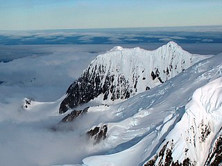
Helmet Peak is a conspicuous peak rising to 1,254 metres (4,114 ft) in Levski Ridge, Tangra Mountains on Livingston Island in the South Shetland Islands, Antarctica just southward of the mouth of Huron Glacier. It is bounded by Devnya Valley to the west, Iskar Glacier to the northeast, and Magura Glacier to the southeast, and has precipitous west and east slopes. It was named by Discovery Investigations personnel during the period 1926–32.
Hurd Peninsula lies between South Bay and False Bay on the south coast of Livingston Island in the South Shetland Islands, Antarctica. The Spanish Juan Carlos I Antarctic Base and the Bulgarian St. Kliment Ohridski Base are situated on its west coast.
Burdick Ridge is a ridge rising to an elevation of 773 metres (2,536 ft) on Livingston Island in the South Shetland Islands. Extending for 1.9 kilometres (1.2 mi) between Orpheus Gate in the southeast and Rezen Saddle in the northwest, it is bounded by Perunika Glacier to the northeast and Balkan Snowfield to the southwest. It takes its name from its highest point, Burdick Peak.
Habermehl Rock is the rock off the north coast of Livingston Island in the South Shetland Islands, Antarctica 37 m long in southeast–northwest direction and 18 m wide, with a surface area of 0.02 ha. The vicinity was visited by early 19th century sealers.


