Kyle of Tongue

Last updated

Kyle of Tongue National Scenic Area
Ben Loyal and the Kyle of Tongue, Sutherland (3-06-2011, 19-25-02).jpg
Ben Loyal on the west side of Kyle of Tongue.
Sutherland UK relief location map.jpg
Red pog.svg
The location of the Kyle of Tongue within Sutherland.
Location Sutherland, Highland, Scotland
Coordinates 58°28′37″N4°27′11″W / 58.477°N 4.453°W / 58.477; -4.453 Coordinates: 58°28′37″N4°27′11″W / 58.477°N 4.453°W / 58.477; -4.453
Area245 km2 (95 sq mi) [1]
Established1981
Governing body NatureScot

The Kyle of Tongue (Scottish Gaelic : Caol Thunga) is a shallow sea loch [2] in northwest Highland, Scotland, in the western part of Sutherland. Featuring a rocky coastline, its mouth is formed at Tongue Bay. The community of Tongue is situated on the Kyle's eastern shore and the loch is crossed by the Kyle of Tongue Bridge and Causeway.

Contents

The sea loch and surrounding countryside is designated as the Kyle of Tongue National Scenic Area , one of the forty such areas in Scotland, which are defined so as to identify areas of exceptional scenery and to ensure its protection from inappropriate development. [3] The designated area covers 24,488  ha in total, of which 21,093 ha is on land, with a further 3396 ha being marine (i.e. below low tide level), [1] and takes in the nearby mountains of Ben Hope and Ben Loyal as well as several small islands and the coastline as far east as Bettyhill. [4]

History

Castle Varrich, overlooking the Kyle. Caisteal Bharraich, Tongue, Scotland - geograph.org.uk - 102467.jpg
Castle Varrich, overlooking the Kyle.

According to the Origines Parochiales Scotiae , Castle Varrich, an old square tower on a hill on the east side of the Kyle, was the residence of Karl Hundason, who made an effort to conquer Scotland on the death of Malcolm II. [5] There are three brochs: on the Kyle's east side opposite Melness; at the head of the Kyle; and at Dunbuie, a hill on the west side of the Kyle. [6]

In 1746, a naval engagement occurred at the Kyle involving Bonnie Prince Charlie's Jacobite rebellion. [7] The Jacobite ship Le Prince Charles, commanded by Captain Richard Talbot, was bringing a large amount of French gold to aid the Jacobite cause. It was chased by a British squadron and one of the Royal Navy frigates eventually caught up with it in the Kyle of Tongue, on 25 February 1746. A fierce five-hour battle took place: the Jacobite ship fought bravely, but in the end was defeated. The failure of the gold to reach the Prince's army was one of the main factors which led to the Battle of Culloden. [8]

Geography

Kyle of Tongue is situated 8 miles (13 km) east of Loch Eriboll. Its western entrance is between Cnoc Glass and Roan Island; the eastern entrance is between Rosin Island and Neave Island. From Roan Island, the Kyle trends in a south and southwest direction for 7 miles (11 km) to Kinloch. A large portion of it is sandy, with a narrow bar-encumbered channel running through it. The depths range from approximately 18 fathoms west of Roan Island to 5 fathoms in the area 1.5 miles (2.4 km) above where the shallows begin. There is no channel into the Kyle of Tongue along the western shore. [9] Derry (or Loch an Dithreibh) is a lake which empties into the head of the Kyle of Tongue. [10] Strathtongue, an 8-mile (13 km) long stream, runs to the Kyle. [11]

Flora and fauna

The surrounding hills are characterized by meadows, grasses, and heath. There is moorland between the Kyle and Loch Eriboll. [12] Much of the area is protected as part of the Natura 2000 network, forming part of the Caithness and Sutherland Peatlands, which are protected as both a Special Protection Area and a Special Area of Conservation. [13] [14] Water fauna within the Kyle include salmon and sea trout, [15] whilst whales and otters can be found at the mouth of the loch. [16] Bird species living in the area include barn swallows, black-headed gulls, ravens, redshanks, wood pigeons, herring gulls, collared doves, curlews, oystercatchers, golden plovers, great black-backed gulls, cormorants, grey herons, greylag geese, house martins, house sparrows, meadow pipits, common gulls, red-throated divers, and rock pigeons. [17] Additionally, a number of raptor species can be found, including golden eagles, hen harriers, merlins and short-eared owls. [13]

Land ownership

Much of the land on the western and southern sides of the Kyle, including the mountains of Ben Hope and Ben Loyal and the former hunting lodge of Kinloch Lodge, belongs to Danish billionaire Anders Holch Povlsen. [18] [19] [20] The land on the eastern shore forms part of the extensive estates of the Countess of Sutherland, currently Elizabeth Sutherland, 24th Countess of Sutherland. [21]

Related Research Articles

Highland (council area) Council area of Scotland

Highland is a council area in the Scottish Highlands and is the largest local government area in the United Kingdom. It was the 7th most populous council area in Scotland at the 2011 census. It shares borders with the council areas of Aberdeenshire, Argyll and Bute, Moray and Perth and Kinross. Their councils, and those of Angus and Stirling, also have areas of the Scottish Highlands within their administrative boundaries.

Sutherland Historic county in Scotland

Sutherland is a historic county, registration county and lieutenancy area in the Highlands of Scotland. Its county town is Dornoch. Sutherland borders Caithness and Moray Firth to the east, Ross-shire and Cromartyshire to the south and the Atlantic to the north and west. Like its southern neighbour Ross-shire, Sutherland has some of the most dramatic scenery in the whole of Europe, especially on its western fringe where the mountains meet the sea. These include high sea cliffs, and very old mountains composed of Precambrian and Cambrian rocks.

Caithness Historic county in northern Scotland

Caithness is a historic county, registration county and lieutenancy area of Scotland.

Durness Human settlement in Scotland

Durness is a village and civil parish in the north-west Highlands of Scotland. It lies on the north coast of the country in the traditional county of Sutherland, around 120 miles north of Inverness. The area is remote, and the parish is huge and sparsely populated, covering an area from east of Loch Eriboll to Cape Wrath, the most north-westerly point of the Scottish mainland.

Tongue, Highland Human settlement in Scotland

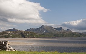
Tongue is a coastal village in northwest Highland, Scotland, in the western part of the former county of Sutherland. It lies on the east shore above the base of the Kyle of Tongue and north of the mountains Ben Hope and Ben Loyal on the A836. To the north lies the area of Braetongue.

Clan Mackay Highland Scottish clan

Clan Mackay is an ancient and once-powerful Highland Scottish clan from the far North of the Scottish Highlands, but with roots in the old Kingdom of Moray. They supported Robert the Bruce during the Wars of Scottish Independence in the 14th century. In the centuries that followed they were anti-Jacobite. The territory of the Clan Mackay consisted of the parishes of Farr, Tongue, Durness and Eddrachillis, and was known as Strathnaver, in the north-west of the county of Sutherland. However, it was not until 1829 that Strathnaver was considered part of Sutherland when the chief sold his lands to the Earls of Sutherland and the Highland Clearances then had dire consequences for the clan. In the 17th century the Mackay chief's territory had extended to the east to include the parish of Reay in the west of the neighbouring county of Caithness. The chief of the clan is Lord Reay and the lands of Strathnaver later became known as the Reay Country.

Bonar Bridge Human settlement in Scotland

Bonar Bridge is a village on the north bank of the Kyle of Sutherland to the west and the Dornoch Firth to the east in the Parish of Creich in the Highland council area of Scotland.

A838 road

The A838 is a major road in Sutherland, in the Highland area of Scotland. It runs generally northwest from the A836 in the Lairg area to Laxford Bridge on the west coast of Scotland, then generally northeast to Durness on the north coast, and then generally east/southeast to Tongue, where it rejoins the A836. The A836 takes a more direct route from Lairg to Tongue.

Clan Sutherland Highland Scottish clan

Clan Sutherland is a Highland Scottish clan whose traditional territory is the shire of Sutherland in the far north of Scotland. The chief of the clan was also the powerful Earl of Sutherland, however in the early 16th century this title passed through marriage to a younger son of the chief of Clan Gordon. The current chief is Alistair Sutherland who holds the title Earl of Sutherland.

Ben Hope

Ben Hope is a mountain in northern Scotland. It is the most northerly Munro, standing alone in the Flow Country south-east of Loch Hope in Sutherland. The mountain is a roughly triangular wedge, with a great crag on the west, with two lower shoulders to the south and northeast. Alpine flowers are abundant in season, although the ground is very rocky.

Clan Sinclair Highland Scottish clan

Clan Sinclair is a Highland Scottish clan who held lands in Caithness, the Orkney Islands, and the Lothians. The chiefs of the clan were the Barons of Roslin and later the Earls of Orkney and Earls of Caithness. The Sinclairs are believed to have come from Normandy to England during the Norman conquest of England, before arriving in Scotland in the 11th century. The Sinclairs supported the Scottish Crown during the Scottish–Norwegian War and the Wars of Scottish Independence. The chiefs were originally Barons of Roslin, Midlothian and William Sinclair, 1st Earl of Caithness and Baron of Roslin founded the famous Rosslyn Chapel in the 15th century. He split the family lands, disinheriting his eldest son from his first marriage, William, who inherited the title of Lord Sinclair, instead giving the lands of Caithness to the second son from his second marriage, William Sinclair, 2nd Earl of Caithness, in 1476, and the lands at Roslin to his eldest son from his second marriage, Sir Oliver Sinclair. In the 16th century the Sinclairs fought against England during the Anglo-Scottish Wars and also feuded with their neighbors the Clan Sutherland. During the Jacobite rising of 1715 the Sinclairs supported the Jacobite cause, but during the Jacobite rising of 1745, while the clan largely had Jacobite sympathies, their chief, the Earl of Caithness, supported the British-Hanoverian Government. The current chief is Malcolm Sinclair, 20th Earl of Caithness.

Battle of Littleferry Battle during the Jacobite rising in 1746, just before the Battle of Culloden

The Battle of Littleferry took place during the Jacobite rising in 1746, just before the Battle of Culloden. Scottish forces loyal to the British-Hanoverian Government defeated a Scottish Jacobite force.

George Mackay of Skibo was a Scottish lawyer, soldier and politician. He fought for the British Government during the Jacobite rising of 1745 and was later a Member of Parliament.

Mackay of Scoury

The Mackays of Scoury were a minor noble Scottish family and a branch of the ancient Clan Mackay, a Highland Scottish clan. They were seated at Scourie Castle, in Scourie, in the parish of Eddrachillis, county of Sutherland. However, Scourie was part of the Mackay chief's province of “Strathnaver” until it was sold to the Earl of Sutherland in 1829.

George Mackay, 3rd Lord Reay (1678–1748), was a Scottish noble and chief of the Clan Mackay, a Scottish clan of the Scottish Highlands. During his life the Glorious Revolution took place which directly affected his family and estate, and during his chiefdom he served the British-Hanoverian Government during the Jacobite rising of 1715 and the Jacobite rising of 1745.

North West Sutherland National Scenic Area

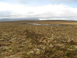
North West Sutherland is a national scenic area (NSA) covering the mountains and coastal scenery of the northwestern part of the county of Sutherland in the highlands of Scotland. The designated area covers the mountains of Foinaven, Arkle and Ben Stack as well as the coastal scenery surrounding Loch Laxford and Handa Island. It is one of 40 such areas in Scotland, which are defined so as to identify areas of exceptional scenery and to ensure its protection by restricting certain forms of development. The North West Sutherland NSA covers 26,565 ha in total, consisting of 23,415 ha of land with a further 3,151 ha being marine.

A Mhòine Peninsula in the Highlands, Scotland

A' Mhòine is a peninsula in the Highlands, Scotland. The peninsula is bounded to the west by Loch Eriboll, and to the east by the Kyle of Tongue. The A838 road crosses the peninsula on an east–west axis. Much of the peninsula is owned by Melness Estate on behalf of 59 crofters.

References

  1. 1 2 "National Scenic Areas - Maps". SNH. 20 December 2010. Archived from the original on 12 June 2018. Retrieved 4 March 2018.
  2. Smith, Robin; Lawson, Alan (2001). The making of Scotland: a comprehensive guide to the growth of its cities, towns, and villages. Canongate U.S. pp. 904–. ISBN   978-1-84195-170-6 . Retrieved 29 December 2011.
  3. "National Scenic Areas". NatureScot. Retrieved 5 October 2020.
  4. "Kyle of Tongue National Scenic Area". NatureScot. Retrieved 5 October 2020.
  5. Gunn, Adam; Mackay, John (1897). Sutherland and the Reay country: history, antiquities, folklore, topography, regiments, ecclesiastical records, poetry and music, etc (Public domain. ed.). J. Mackay. pp. 113–. Retrieved 29 December 2011.
  6. Society of Antiquaries of Scotland (1890). Transactions of the Society of Antiquaries of Scotland (Public domain ed.). W. and A. Smellie for W. Creech, Edinburgh, and T. Cadell, London. pp. 191–. Retrieved 29 December 2011.
  7. Reid, Donald; Humphreys, Rob (2 May 2011). The Rough Guide to Scottish Highlands & Islands. Penguin. pp. 524–. ISBN   978-1-4053-8942-6 . Retrieved 29 December 2011.
  8. C. Duffy, The 45 (2003), pp. 461–464.
  9. United States. Hydrographic Office (1915). British Islands pilot (Public domain ed.). Govt. print. off. pp. 339, 343–. Retrieved 29 December 2011.
  10. Groome, Francis Hindes (1882). Ordnance gazetteer of Scotland: a survey of Scottish topography, statistical, biographical and historical (Public domain ed.). T. C. Jack. pp. 352–. Retrieved 29 December 2011.
  11. The Topographical, Statistical, and Historical Gazetteer of Scotland: I-Z (Public domain ed.). A. Fullarton. 1853. pp. 761–. Retrieved 29 December 2011.
  12. Seemann, Berthold (1 January 1885). Journal of Botany, British and Foreign (Public domain ed.). West, Newman & Co. pp. 836–. Retrieved 29 December 2011.
  13. 1 2 "Caithness and Sutherland Peatlands SPA". NatureScot. Retrieved 5 October 2020.
  14. "Caithness and Sutherland Peatlands SAC". NatureScot. Retrieved 5 October 2020.
  15. "Tongue". Mackay Country. Archived from the original on 3 January 2013. Retrieved 29 December 2011.
  16. Scottish Canoe Association (20 May 2005). Scottish Canoe Touring: An SCA Canoe and Kayak Guide. Pesda Press. pp. 22–. ISBN   978-0-9547061-3-5 . Retrieved 29 December 2011.
  17. "Kyle of Tongue, Scotland". birdingsiteguide.com. 3 August 2008. Retrieved 29 December 2011.
  18. "Property Page: Ben Loyal Estate". Who Owns Scotland. 22 November 2012. Retrieved 7 April 2018.
  19. "Property Page: Kinloch Estate". Who Owns Scotland. 18 May 2012. Retrieved 7 April 2018.
  20. "Property Page: Hope and Melness Estate". Who Owns Scotland. 31 December 2002. Retrieved 7 April 2018.
  21. "Property Page: Sutherland Estate". Who Owns Scotland. 31 December 2002. Retrieved 7 April 2018.