Hoy and West Mainland National Scenic Area

Last updated

Hoy and West Mainland National Scenic Area
Old man of hoy2.jpg
The Old Man of Hoy, at the western side of Hoy, seen from the south.
Hoy-and-west-mainland-NSA.png
Location Orkney, Scotland
Coordinates 58°56′N3°12′W / 58.94°N 3.20°W / 58.94; -3.20
Area244 km2 (94 sq mi) [1]
Established1981
Governing body NatureScot

Hoy and West Mainland is a national scenic area (NSA) covering parts of the islands of Hoy and Mainland in the Orkney Islands of Scotland, as well as parts of the surrounding sea. [2] It is one of 40 such areas in Scotland, which are defined so as to identify areas of exceptional scenery and to ensure its protection by restricting certain forms of development. [3] The Hoy and West Mainland NSA covers 24,407  ha in total, consisting of 16,479 ha of land with a further 7928 ha being marine (i.e. below low tide). [1]

Contents

National scenic areas are primarily designated due to the scenic qualities of an area, however NSAs may well have other special qualities, for example related to culture, history, archaeology, geology or wildlife. Areas with such qualities may be protected via other national and international designations that overlap with the NSA designation. [4] Hoy and West Mainland includes one of the six World Heritage Sites in Scotland, and there are several Special Areas of Conservation and Special Protection Areas within the NSA. [5]

Creation of the national scenic area

Following the Second World War, a committee, chaired by Sir Douglas Ramsay, was established to consider preservation of the landscape in Scotland. The report, published in 1945 proposed that five areas (Loch Lomond and the Trossachs, the Cairngorms, Glen Coe-Ben Nevis-Black Mount, Wester Ross and Glen Strathfarrar-Glen Affric-Glen Cannich) should receive a level of protection. [6] Accordingly, the government designated these areas as "national park direction areas", giving powers for planning decisions taken by local authorities to be reviewed by central government. Following a further review of landscape protection in 1978, additional areas, including the northern part of the island of Hoy and the western part of the Orkney mainland, were identified as worthy of protection due to their landscape qualities. Accordingly, in 1981 the direction areas were replaced by the national scenic area designation, which were based on the 1978 recommendations and thus included the area entitled Hoy and West Mainland. [7] The defined area remains as originally mapped in 1978, but was redesignated under new legislation in 2010. [8]

Although the national scenic area designation provides a degree of additional protection via the planning process, there are no bodies equivalent to a national park authority, [9] and whilst local authorities (in this case Orkney Islands Council) can produce a management strategy for each one, only the three national scenic areas within Dumfries and Galloway have current management strategies. [10]

Landscape and scenery

Main articles: Hoy, Mainland, Orkney and Heart of Neolithic Orkney

The bold, rounded hills of North Hoy are a dominant feature across the area, and contrast with the pastoral landscape of West Mainland. [11] Human activity has played an important part in producing the current landscape, with the neolithic monuments of the Heart of Neolithic Orkney sitting at the heart of the scattered farm steadings and stone dykes surrounding the Loch of Stenness. [11]

The dramatic coastline of Hoy greets visitors travelling to Orkney by ferry from the Scottish mainland. It has extremes of many kinds: some of the highest sea cliffs in the UK at St John's Head, which reach 350 m; [12] a light-stone precarious sea stack taller than the facing cliff the Old Man of Hoy; patches of northernmost scattered, hardy woodland and the remote possibility of locally extant Orkney charr ( Salvelinus inframundus ) documented in 1908 at Heldale Water. [13] The most northerly Martello Towers stand here built to defend the south entrance to Scapa Flow at Longhope in 1814 towards the end of the Napoleonic War, never used in combat. The highest point in the archipelago, Ward Hill, is on Hoy.

West Mainland by contrast presents a softer landscape, described by SNH as "a palimpsest of geology, topography, archaeology and land use". [11] The area shows evidence of having been settled and farmed for many thousands of years. The view of the town of Stromness, and its link with the sea were also identified as "special qualities" of the area by Scottish Natural Heritage. [11]

The Standing Stones of Stenness. Standing Stones of Stenness 062015.jpg
The Standing Stones of Stenness.

The national scenic area includes the Heart of Neolithic Orkney, a group of Neolithic monuments found in the West Mainland portion of the area. The name was adopted by UNESCO when it proclaimed these sites as a World Heritage Site in 1999. The site of patrimony currently consists of four sites:

  1. Maeshowe – a unique chambered cairn and passage grave, aligned so that its central chamber is illuminated on the winter solstice. It was looted by Vikings who left one of the largest collections of runic inscriptions in the world. [14]
  2. Standing Stones of Stenness – the four remaining megaliths of a henge, the largest of which is 6 metres (19 ft) high. [15] [16]
  3. Ring of Brodgar – a stone circle 104 metres in diameter, originally composed of 60 stones set within a circular ditch up to 3 metres deep and 10 metres wide, forming a henge monument. It has been estimated that the structure took 80,000 man-hours to construct. [17] [16]
  4. Skara Brae – a cluster of eight houses making up Northern Europe’s best-preserved Neolithic village. [18]

There are also neolithic remains on Hoy, the most prominent of which is a megalithic chambered tomb carved out of a titanic block of Devonian Old Red Sandstone, [19] and known as the Dwarfie Stane, which lies in the Rackwick valley on the edge of the national scenic area. It is the only chambered tomb in Orkney that is cut from stone rather than built from stones [20] and may be the only example of a Neolithic rock-cut tomb in Britain. [21]

Conservations designations

There are three Special Areas of Conservation (SAC) within the NSA:

The Hoy portion of the NSA, along with much of the adjoining sea area, is designated as a Special Protection Area [5] due to its importance for nine breeding bird species: arctic skua, fulmar, great black-backed gull, great skua, guillemot, black-legged kittiwake, peregrine falcon, puffin and red-throated diver. [25] The area is important for it seabird assemblage, which regularly supports 120,000 individual seabirds during the breeding season. [26]

Related Research Articles

<span class="mw-page-title-main">Orkney</span> Archipelago, county and council area in northern Scotland

Orkney, also known as the Orkney Islands or The Orkneys, is an archipelago in the Northern Isles of Scotland, situated off the north coast of the island of Great Britain. Orkney is 10 miles (16 km) north of the coast of Caithness and has about 70 islands, of which 20 are inhabited. The largest island, the Mainland, has an area of 523 square kilometres (202 sq mi), making it the sixth-largest Scottish island and the tenth-largest island in the British Isles. Orkney's largest settlement, and also its administrative centre, is Kirkwall.

<span class="mw-page-title-main">Hoy, Orkney</span> Island in the Orkney Islands group

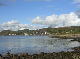
Hoy is an island in Orkney, Scotland, measuring 143 square kilometres (55 sq mi) – the second largest in the archipelago, after Mainland. A natural causeway, the Ayre, links the island to the smaller South Walls; the two islands are treated as one entity by the UK census. Hoy lies within the parish of Stromness.

<span class="mw-page-title-main">NatureScot</span> Scottish government agency for natural heritage conservation

NatureScot is the operating name for the body formally called Scottish Natural Heritage. It is an executive non-departmental public body of the Scottish Government responsible for the country's natural heritage, especially its natural, genetic and scenic diversity. It advises the Scottish Government on nature conservation, and acts as a government agent in the delivery of conservation designations, i.e. national nature reserves, local nature reserves, national parks, Sites of Special Scientific Interest (SSSIs), Special Areas of Conservation, Special Protection Areas and the national scenic areas. It receives annual funding from the Government in the form of Grant in Aid to deliver Government priorities for the natural heritage.

<span class="mw-page-title-main">Stones of Stenness</span> Henge in Orkney Islands, Scotland, UK

The Standing Stones of Stenness is a Neolithic monument five miles northeast of Stromness on the mainland of Orkney, Scotland. This may be the oldest henge site in the British Isles. Various traditions associated with the stones survived into the modern era and they form part of the Heart of Neolithic Orkney World Heritage Site. They are looked after by Historic Environment Scotland as a scheduled monument.

<span class="mw-page-title-main">Dornoch Firth</span> Scottish firth

The Dornoch Firth is a firth on the east coast of Highland, in northern Scotland. It forms part of the boundary between Ross and Cromarty, to the south, and Sutherland, to the north. The firth is designated as a national scenic area, one of 40 such areas in Scotland. The national scenic area covers 15,782 ha in total, of which 4,240 ha is the marine area of the firth below low tide. A review of the national scenic areas by Scottish Natural Heritage in 2010 commented:

By comparison with other east coast firths the Dornoch Firth is narrow and sinuous, yet it exhibits within its compass a surprising variety of landscapes. It is enclosed by abrupt rounded granitic hills clad in heather moor and scree, their Gaelic names of cnoc, meall and creag giving the clue to their character. Their lower slopes are frequently wooded, oakwoods being a noticeable feature of the area, but with other deciduous and coniferous species represented in plantations which vary from the policy plantings of Skibo Castle to the pines of the Struie Forest.

<span class="mw-page-title-main">Water of Fleet</span> River in Scotland

The Water of Fleet is a river in Scotland flowing into Fleet Bay on the Solway Firth. Its two tributaries are the Big Water of Fleet, which begins around Loch Grannoch, and the Little Water of Fleet. The river flows through Gatehouse of Fleet before meeting the sea.

<span class="mw-page-title-main">Dwarfie Stane</span> Carved Megalithic chambered tomb in Scotland

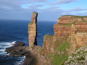
The Dwarfie Stane is a megalithic chambered tomb carved out of a titanic block of Devonian Old Red Sandstone located in a steep-sided glaciated valley between the settlements of Quoys and Rackwick on Hoy, an island in Orkney, Scotland. The stone is a glacial erratic located in desolate peatland. The site is managed by Historic Environment Scotland.

<span class="mw-page-title-main">Loch of Stenness</span> Brackish loch in Orkney, Scotland

The Loch of Stenness is a large brackish loch on Mainland, Orkney, Scotland and is named for the parish of Stenness. It is 2 miles northeast of the town of Stromness, lies immediately to the south of the Loch of Harray and is close to the World Heritage neolithic sites of the Stones of Stenness and Ring of Brodgar. In Old Norse its name was Steinnesvatn.

<span class="mw-page-title-main">Loch of Harray</span> Freshwater loch in Mainland Orkney, Scotland

The Loch of Harray is the largest loch of Mainland Orkney, Scotland and is named for the parish of Harray. It lies immediately north of the Loch of Stenness and is close to the World Heritage neolithic sites of the Stones of Stenness and Ring of Brodgar. In Old Norse its name was Heraðvatn.

<span class="mw-page-title-main">Prehistoric Orkney</span> Overview of the prehistoric period on the Orkney Islands, Scotland

Prehistoric Orkney refers only to the prehistory of the Orkney archipelago of Scotland that begins with human occupation. Although some records referring to Orkney survive that were written during the Roman invasions of Scotland, “prehistory” in northern Scotland is defined as lasting until the start of Scotland's Early Historic Period.

<span class="mw-page-title-main">Rough Firth</span> Fjord in Dumfries and Galloway, Scotland, UK

Rough Firth is an inlet on the northern coast of the Solway Firth in the Stewartry area of Dumfries and Galloway, Scotland. The firth lies between Almorness Point and Castlehill Point, and contains Rough Island. The village of Kippford stands near the head of the firth where the Urr Water reaches the sea; the only other coastal settlement of any size is Rockcliffe. The area is designated as the East Stewartry Coast National Scenic Area, one of the forty national scenic areas (NSAs) in Scotland.

<span class="mw-page-title-main">South Lewis, Harris and North Uist National Scenic Area</span>

South Lewis, Harris and North Uist is a large national scenic area (NSA) in the Western Isles of Scotland. It is one of 40 such areas in Scotland, which are defined so as to identify areas of exceptional scenery and to ensure its protection from inappropriate development. The designated area covers 202,388 ha in total, of which 112,301 ha is on land, with a further 90,087 ha being marine, making it the largest of the NSAs in both total and marine area. The designated area includes the mountainous south west of Lewis, all of Harris, the Sound of Harris and the northern part of North Uist.

<span class="mw-page-title-main">National scenic area (Scotland)</span> Conservation designation used in Scotland

National scenic area (NSA) is a conservation designation used in Scotland, and administered by NatureScot on behalf of the Scottish Government. The designation's purpose is to identify areas of exceptional scenery and to protect them from inappropriate development. There are currently 40 national scenic areas (NSAs) in Scotland, covering 13% of the land area of Scotland. The areas protected by the designation are considered to represent the type of scenic beauty "popularly associated with Scotland and for which it is renowned". As such they tend to be mainly found in remote and mountainous areas, with a review in 1997 noting a potential weakness of national scenic areas was that the original selection placed undue emphasis on mountainous parts of the country. National scenic areas do however also cover seascapes, with approximately 26% of the total area protected by the designation being marine. The designation is primarily concerned with scenic qualities, although designated national scenic areas may well have other special qualities, for example related to culture, history, archaeology, geology or wildlife. Areas with such qualities may be protected by other designations that overlap with the NSA designation.

<span class="mw-page-title-main">Protected areas of Scotland</span> Designated area for protection in Scotland

Many parts of Scotland are protected in accordance with a number of national and international designations because of their environmental, historical or cultural value. Protected areas can be divided according to the type of resource which each seeks to protect. NatureScot has various roles in the delivery of many environmental designations in Scotland, i.e. those aimed at protecting flora and fauna, scenic qualities and geological features. Historic Environment Scotland is responsible for designations that protect sites of historic and cultural importance. Some international designations, such as World Heritage Sites, can cover both categories of site.

<span class="mw-page-title-main">Ben Nevis and Glen Coe National Scenic Area</span>

Ben Nevis and Glen Coe is a national scenic area (NSA) covering part of the Highlands of Scotland surrounding Ben Nevis and Glen Coe, in which certain forms of development are restricted. It is one of 40 such areas in Scotland, which are defined so as to identify areas of exceptional scenery and to ensure its protection from inappropriate development. The Ben Nevis and Glen Coe NSA covers 903 km2 (349 sq mi) of land, lying within the Highland, Argyll and Bute and Perth and Kinross council areas. A further 19 km2 (7.3 sq mi) of the NSA are marine, covering the sea loch of Loch Leven.

<span class="mw-page-title-main">Loch Rannoch and Glen Lyon National Scenic Area</span>

The Loch Rannoch and Glen Lyon National Scenic Area is a national scenic area (NSA) covering the area surrounding Loch Rannoch, Glen Lyon, and the Ben Lawers ranges of mountains in Scotland. It is one of 40 such areas in Scotland, which are defined so as to identify areas of exceptional scenery and to ensure its protection from inappropriate development by restricting certain forms of development. The Loch Rannoch and Glen Lyon NSA covers 48,625 ha, most of which lies in the council area of Perth and Kinross, with a small portion lying in Stirling.

<span class="mw-page-title-main">Morar, Moidart and Ardnamurchan National Scenic Area</span> National scenic area in Scotland

Morar, Moidart and Ardnamurchan is a national scenic area (NSA) covering the coastal scenery of three peninsulas in the western Highlands of Scotland: Ardnamurchan, Moidart and Morar. It is one of 40 such areas in Scotland, which are defined so as to identify areas of exceptional scenery and to ensure its protection from inappropriate development by restricting certain forms of development. The Morar, Moidart and Ardnamurchan NSA covers 36,956 ha in total, consisting of 17,220 ha of land with a further 19,736 ha being marine.

<span class="mw-page-title-main">North West Sutherland National Scenic Area</span>

North West Sutherland is a national scenic area (NSA) covering the mountains and coastal scenery of the northwestern part of the county of Sutherland in the highlands of Scotland. The designated area covers the mountains of Foinaven, Arkle and Ben Stack as well as the coastal scenery surrounding Loch Laxford and Handa Island. It is one of 40 such areas in Scotland, which are defined so as to identify areas of exceptional scenery and to ensure its protection by restricting certain forms of development. The North West Sutherland NSA covers 26,565 ha in total, consisting of 23,415 ha of land with a further 3,151 ha being marine.

<span class="mw-page-title-main">Scarba, Lunga and the Garvellachs National Scenic Area</span>

Scarba, Lunga and the Garvellachs is the name of one of the 40 national scenic areas of Scotland. The designated area covers the islands of Scarba, Lunga, and the Garvellachs, all of which lie in the Firth of Lorn, along with much of the surrounding seascape. The national scenic areas are defined so as to identify areas of exceptional scenery and to ensure its protection by restricting certain forms of development, and are considered to represent the type of scenic beauty "popularly associated with Scotland and for which it is renowned". The Scarba, Lunga and the Garvellachs NSA covers 6,542 ha in total, consisting of 2,139 ha of land with a further 4,402 ha being marine.

<span class="mw-page-title-main">Upper Tweeddale National Scenic Area</span>

The Upper Tweeddale National Scenic Area lies in the Borders region of Scotland. It is one of 40 national scenic areas (NSA) in Scotland, which are defined so as to identify areas of exceptional scenery and to ensure their protection from inappropriate development. The designated area covers 12,770 ha of countryside surrounding the upper reaches of the River Tweed between Broughton and Peebles.

References

  1. 1 2 "National Scenic Areas - Maps". SNH. 20 December 2010. Archived from the original on 12 June 2018. Retrieved 24 January 2018.
  2. "Hoy and West Mainland National Scenic Area". NatureScot. Retrieved 6 October 2020.
  3. "National Scenic Areas". NatureScot. Retrieved 6 October 2020.
  4. "The special qualities of the National Scenic Areas" (PDF). Scottish Natural Heritage. 2010. p. 2. Retrieved 24 January 2018.
  5. "History Leading to the Cairngorms National Park". Cairngorms National Park Authority. Archived from the original on 15 January 2018. Retrieved 15 January 2018.
  6. "National Scenic Areas Review" (PDF). SNH. 1997. Archived from the original (PDF) on 6 February 2018. Retrieved 5 February 2018.
  7. "National Scenic Areas: background, guidance and policy". NatureScot. Retrieved 6 October 2020.
  8. "Development management and National Scenic Areas". NatureScot. Retrieved 6 October 2020.
  9. "National Scenic Areas (NSAs)". Dumfries and Galloway council. 8 December 2017. Retrieved 24 January 2018.
  10. 1 2 3 4 "The special qualities of the National Scenic Areas" (PDF). Scottish Natural Heritage. 2010. pp. 286–294. Retrieved 24 January 2018.
  11. Haswell-Smith, Hamish (2004). The Scottish Islands. Edinburgh: Canongate. pp. 344–6. ISBN   978-1-84195-454-7.
  12. IUCN Red List
  13. "Maeshowe". Orkneyjar. Retrieved 11 February 2008.
  14. "The Standing Stones o' Stenness". Orkneyjar. Retrieved 16 September 2008.
  15. 1 2 Wickham-Jones, Caroline (2007). Orkney: A Historical Guide. Edinburgh: Birlinn. pp. 28–29. ISBN   9781841585963..
  16. " The Ring o' Brodgar, Stenness ". Orkneyjar. Retrieved 16 September 2008.
  17. "Skara Brae Prehistoric Village" Historic Scotland. Retrieved 16 August 2009.
  18. "The Dwarfie Stane, Hoy" Orkneyjar. Retrieved 27 May 2010.
  19. Laing, Lloyd (1974). Orkney and Shetland: An Archaeological Guide. Newton Abbott: David and Charles Ltd. p. 48. ISBN   0-7153-6305-0.
  20. Historic Environment Scotland. "Hoy, Dwarfie Stane (1597)". Canmore .
  21. "Hoy SAC". NatureScot. Retrieved 6 October 2020.
  22. "Stromness Heaths and Coast SAC". NatureScot. Retrieved 6 October 2020.
  23. "Loch of Stenness SAC". NatureScot. Retrieved 6 October 2020.
  24. "Hoy SPA". NatureScot. Retrieved 6 October 2020.
  25. "SPA Description (Hoy)". Joint Nature Conservation Committee. 21 July 2005. Retrieved 21 March 2018.