Kirkkonummi is a municipality in Finland, located in the southern coast of the country. Kirkkonummi is situated in the western part of the Uusimaa region. The population of Kirkkonummi is approximately 41,000. It is the 28th most populous municipality in Finland. Kirkkonummi is part of the Helsinki Metropolitan Area, which has approximately 1.6 million inhabitants.
Sipoo is a municipality of Finland. It is part of the Helsinki metropolitan area. The municipality has a population of 22,840 (31 August 2024) and covers an area of 698.60 square kilometres (269.73 sq mi) of which 358.97 km2 (138.60 sq mi) is water. The population density is 67.24 inhabitants per square kilometre (174.2/sq mi). The administrative center of the municipality is Nikkilä, which is located 34 kilometres (21 mi) northeast of the center of Helsinki. Another significant urban area is Söderkulla, located in the southern part of the municipality.
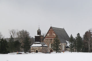
Suomussalmi is a municipality in Finland and is located in the Kainuu region about 90 kilometres (56 mi) northeast of Kajaani, the capital of Kainuu and 120 kilometres (75 mi) south of Kuusamo. The municipality has a population of 7,100 (31 August 2024) and covers an area of 5,857.60 square kilometres (2,261.63 sq mi) of which 587.03 km2 (226.65 sq mi) is water. The population density is 1.35 inhabitants per square kilometre (3.5/sq mi). The municipality is unilingually Finnish. Ämmänsaari is the biggest built-up area in the municipality.

Kouvola is a city in Finland and the administrative capital of Kymenlaakso. It is located in the southeastern interior of the country. The population of Kouvola is approximately 79,000. It is the 11th most populous municipality in Finland, and the 17th most populous urban area in the country.

Nousiainen is a municipality of Finland. It is located in the Southwest Finland region, 20 kilometres (12 mi) from Turku along Highway 8 (E8). The Finnish-speaking municipality has a population of 4,664 (31 August 2024) and covers an area of 199.55 square kilometres (77.05 sq mi) of which 0.62 km2 (0.24 sq mi) is water. The population density is 23.45 inhabitants per square kilometre (60.7/sq mi).

Pirkkala is a municipality in Finland, located in the Pirkanmaa region. It lies to the southwest of the regional capital, Tampere. The population of Pirkkala is approximately 21,000, while the metropolitan area has a population of approximately 421,000. It is the 49th most populous municipality in Finland.

Liminka is a municipality in the Northern Ostrobothnia region in Finland. Liminka is located about 25 kilometres (16 mi) south of Oulu.

Hankasalmi is a municipality of Finland.

Jalasjärvi is a former municipality of Finland. It was merged to the town of Kurikka on 1 January 2016.

Kaarina is a town in Finland, located in the region of Southwest Finland. It lies south of the regional capital, Turku. The population of Kaarina is approximately 37,000, while the sub-region has a population of approximately 350,000. It is the 31st most populous municipality in Finland, and the second largest municipality in the Southwest Finland region after Turku.

Hämeenkoski is a former municipality of Finland. It was merged to the municipality of Hollola on 1 January 2016.

Loimaa is a town and municipality of Finland.

Nummi-Pusula is a former municipality of Finland. Its seat was in Nummi. Nummi-Pusula was formed in 1981 from the former municipalities Nummi and Pusula. With Karjalohja, it was merged with the town of Lohja on 1 January 2013.

Närpes is a town in Finland, located on the west coast of the country. Närpes is situated in Ostrobothnia, along the Gulf of Bothnia. The population of Närpes is approximately 10,000, while the sub-region has a population of approximately 17,000. It is the 101st most populous municipality in Finland.

Paimio is a town and municipality of Finland.

Perho is a municipality of Finland. It is located in the province of Western Finland and is part of the Central Ostrobothnia region. The distance between Perho and the regional center Kokkola is about 100 kilometres (62 mi). The municipality has a population of 2,588 and covers an area of 775.19 square kilometres (299.30 sq mi) of which 27.25 km2 (10.52 sq mi) is water. The population density is 3.46 inhabitants per square kilometre (9.0/sq mi).

Salo is a town in Finland, located in the southwestern interior of the country. The population of Salo is approximately 51,000, while the sub-region has a population of approximately 59,000. It is the 20th most populous municipality in Finland, and the 24th most populous urban area in the country.

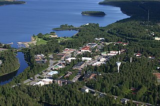
Viitasaari is a Finnish town and municipality located in the Central Finland region. It is located between the neighbouring municipalities of Pihtipudas to the north and Äänekoski to the south. The town has a population of 5,768 (31 August 2024) and covers an area of 1,589.13 square kilometres (613.57 sq mi) of which 340.43 km2 (131.44 sq mi), or 21%, is water. There are all together 230 lakes in Viitasaari. The biggest lakes are Lake Keitele, Lake Kolima and Muuruejärvi. The population density is 4.62 inhabitants per square kilometre (12.0/sq mi).

Akaa is a town and a municipality in Pirkanmaa, Finland. It was created on January 1, 2007 when the town of Toijala and the town of Viiala were united into a single Municipality. The municipality of Kylmäkoski was consolidated with Akaa on 1 January 2011.
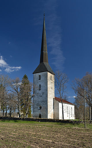
Kõo Parish was a rural municipality of Estonia, in Viljandi County. It had a population of 1,194 and an area of 149.46 km².