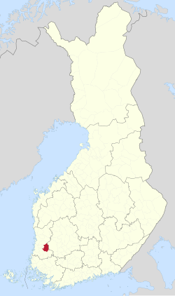
{{lang|sv|Kumo stad}}"},"other_name":{"wt":"Kumo"},"settlement_type":{"wt":"Town"},"image_skyline":{"wt":"Old hotel Seurahuone in Tulkkila Kokemäki Finland.jpg"},"image_caption":{"wt":"An old hotel Seurahuone in Tulkkila, Kokemäki"},"image_shield":{"wt":"Kokemäki.vaakuna.svg"},"shield_size":{"wt":"120x80px"},"image_map":{"wt":"Kokemäki sijainti Suomi.svg"},"map_caption":{"wt":"Location of Kokemäki in Finland"},"coordinates":{"wt":"{{coord|61|15.5|N|022|21|E|display=inline,title}}"},"subdivision_type":{"wt":"Country"},"subdivision_name":{"wt":"{{flag|Finland}}"},"subdivision_type1":{"wt":"[[Regions of Finland|Region]]"},"subdivision_name1":{"wt":"[[Satakunta]]"},"subdivision_type2":{"wt":"[[Sub-regions of Finland|Sub-region]]"},"subdivision_name2":{"wt":"Pori sub-region"},"leader_title":{"wt":"Town manager"},"leader_name":{"wt":"Reijo Siltala"},"established_title":{"wt":"[[Parish]]"},"established_date":{"wt":"1324"},"established_title2":{"wt":"[[Charter]]"},"established_date2":{"wt":"1869"},"established_title3":{"wt":"[[Town privileges]]"},"established_date3":{"wt":"1977"},"area_footnotes":{"wt":"{{Data Finland municipality|area_footnotes|Kokemäki}}"},"area_total_km2":{"wt":"{{Data Finland municipality|area_total_km2|Kokemäki}}"},"area_land_km2":{"wt":"{{Data Finland municipality|area_land_km2|Kokemäki}}"},"area_water_km2":{"wt":"{{Data Finland municipality|area_water_km2|Kokemäki}}"},"area_rank":{"wt":"{{Data Finland municipality|area_rank|Kokemäki}}"},"population_as_of":{"wt":"{{Data Finland municipality|population_as_of|Kokemäki}}"},"population_footnotes":{"wt":"{{Data Finland municipality|population_footnotes|Kokemäki}}"},"population_total":{"wt":"{{Data Finland municipality|population_total|Kokemäki}}"},"population_density_km2":{"wt":"{{Data Finland municipality|population_density_km2|Kokemäki}}"},"population_rank":{"wt":"{{Data Finland municipality|population_rank|Kokemäki}}"},"demographics_type1":{"wt":"{{Data Finland municipality|demographics_type1|Kokemäki}}"},"demographics1_footnotes":{"wt":"{{Data Finland municipality|population_footnotes|Kokemäki}}"},"demographics1_title1":{"wt":"{{Data Finland municipality|demographics1_title1|Kokemäki}}"},"demographics1_info1":{"wt":"{{Data Finland municipality|demographics1_info1|Kokemäki}}"},"demographics1_title2":{"wt":"{{Data Finland municipality|demographics1_title2|Kokemäki}}"},"demographics1_info2":{"wt":"{{Data Finland municipality|demographics1_info2|Kokemäki}}"},"demographics1_title3":{"wt":"{{Data Finland municipality|demographics1_title3|Kokemäki}}"},"demographics1_info3":{"wt":"{{Data Finland municipality|demographics1_info3|Kokemäki}}"},"demographics1_title4":{"wt":"{{Data Finland municipality|demographics1_title4|Kokemäki}}"},"demographics1_info4":{"wt":"{{Data Finland municipality|demographics1_info4|Kokemäki}}"},"demographics_type2":{"wt":"{{Data Finland municipality|demographics_type2|Kokemäki}}"},"demographics2_footnotes":{"wt":"{{Data Finland municipality|demographics2_footnotes|Kokemäki}}"},"demographics2_title1":{"wt":"{{Data Finland municipality|demographics2_title1|Kokemäki}}"},"demographics2_info1":{"wt":"{{Data Finland municipality|demographics2_info1|Kokemäki}}"},"demographics2_title2":{"wt":"{{Data Finland municipality|demographics2_title2|Kokemäki}}"},"demographics2_info2":{"wt":"{{Data Finland municipality|demographics2_info2|Kokemäki}}"},"demographics2_title3":{"wt":"{{Data Finland municipality|demographics2_title3|Kokemäki}}"},"demographics2_info3":{"wt":"{{Data Finland municipality|demographics2_info3|Kokemäki}}"},"blank_name":{"wt":"{{Data Finland municipality|blank_name|Kokemäki}}"},"blank_info":{"wt":"{{Data Finland municipality|blank_info|Kokemäki}}"},"blank3_name":{"wt":"[[Köppen climate classification|Climate]]"},"blank3_info":{"wt":"[[Subarctic climate|Dfc]]"},"timezone":{"wt":"[[Eastern European Time|EET]]"},"utc_offset":{"wt":"+02:00"},"timezone_DST":{"wt":"[[Eastern European Summer Time|EEST]]"},"utc_offset_DST":{"wt":"+03:00"},"website":{"wt":"{{Official URL}}"}},"i":0}}]}" id="mwBQ">Town in Satakunta, Finland
Kokemäki Kumo | |
---|---|
Town | |
Kokemäen kaupunki Kumo stad | |
![]() An old hotel Seurahuone in Tulkkila, Kokemäki | |
![]() Location of Kokemäki in Finland | |
Coordinates: 61°15.5′N022°21′E / 61.2583°N 22.350°E | |
Country | ![]() |
Region | Satakunta |
Sub-region | Pori sub-region |
Parish | 1324 |
Charter | 1869 |
Town privileges | 1977 |
Government | |
• Town manager | Reijo Siltala |
Area (2018-01-01) [1] | |
• Total | 531.27 km2 (205.12 sq mi) |
• Land | 480.42 km2 (185.49 sq mi) |
• Water | 50.04 km2 (19.32 sq mi) |
• Rank | 181st largest in Finland |
Population (2024-10-31) [2] | |
• Total | 6,710 |
• Rank | 135th largest in Finland |
• Density | 13.97/km2 (36.2/sq mi) |
Population by native language | |
• Finnish | |
• Swedish | |
• Others | |
Population by age | |
• 0 to 14 | |
• 15 to 64 | |
• 65 or older | |
Time zone | UTC+02:00 (EET) |
• Summer (DST) | UTC+03:00 (EEST) |
Climate | Dfc |
Website | en |
Kokemäki (Finnish: [ˈkokeˌmæki] ; Swedish : Kumo) is a town and municipality in the Satakunta Region of Finland. The town has a population of 6,710 (31 October 2024) [2] and covers an area of 531.27 square kilometres (205.12 sq mi) of which 50.04 km2 (19.32 sq mi) is water. [1] The population density is 13.97 inhabitants per square kilometre (36.2/sq mi).
Finland is constitutionally bi-lingual with a Swedish speaking minority. The municipality is unilingual with the vast majority of the population speaking Finnish. Many, mostly younger, residents are able to understand or speak some English.
The American battery company Æsir Technologies Inc. has announced that it will establish a nickel hydroxide plant producing material for nickel-zinc batteries in the village of Peipohja of Kokemäki. [4] [5] [6] [7]
The Kokemäki coat of arms depicts the bishop's mitre.
The 121 kilometres (75 mi) long Kokemäki River (Kokemäenjoki) flows from Lake Liekovesi, in the Pirkanmaa region, through Kokemäki and in to the Gulf of Bothnia at Pori. The Kolsi hydro-electric power plant is located at Kokemäki. Kokemäki River has long been an important waterway, well known for its salmon, whitefish and lamprey. [8]
Climate data for Kokemäki Tulkkila (1991-2020 normals, extremes 1959-present from Rausenkulma & Tulkkila) | |||||||||||||
---|---|---|---|---|---|---|---|---|---|---|---|---|---|
Month | Jan | Feb | Mar | Apr | May | Jun | Jul | Aug | Sep | Oct | Nov | Dec | Year |
Record high °C (°F) | 9.5 (49.1) | 9.5 (49.1) | 15.1 (59.2) | 23.3 (73.9) | 29.6 (85.3) | 32.6 (90.7) | 33.0 (91.4) | 31.9 (89.4) | 27.7 (81.9) | 18.5 (65.3) | 13.8 (56.8) | 11.3 (52.3) | 33.0 (91.4) |
Mean daily maximum °C (°F) | −1.8 (28.8) | −1.9 (28.6) | 2.3 (36.1) | 8.9 (48.0) | 15.5 (59.9) | 19.6 (67.3) | 22.3 (72.1) | 21.0 (69.8) | 15.4 (59.7) | 8.2 (46.8) | 2.9 (37.2) | 0.1 (32.2) | 9.4 (48.9) |
Daily mean °C (°F) | −4.5 (23.9) | −5.1 (22.8) | −1.6 (29.1) | 4.1 (39.4) | 10.1 (50.2) | 14.5 (58.1) | 17.2 (63.0) | 15.8 (60.4) | 10.8 (51.4) | 5.2 (41.4) | 1.0 (33.8) | −2.2 (28.0) | 5.4 (41.7) |
Mean daily minimum °C (°F) | −7.7 (18.1) | −8.7 (16.3) | −5.6 (21.9) | −0.3 (31.5) | 4.2 (39.6) | 8.9 (48.0) | 11.7 (53.1) | 10.6 (51.1) | 6.6 (43.9) | 2.3 (36.1) | −1.3 (29.7) | −4.9 (23.2) | 1.3 (34.3) |
Record low °C (°F) | −37.5 (−35.5) | −39.7 (−39.5) | −31.5 (−24.7) | −20.6 (−5.1) | −5.7 (21.7) | −2.4 (27.7) | 0.0 (32.0) | −0.9 (30.4) | −7.6 (18.3) | −16.9 (1.6) | −24.1 (−11.4) | −35.5 (−31.9) | −39.7 (−39.5) |
Average precipitation mm (inches) | 44 (1.7) | 33 (1.3) | 29 (1.1) | 29 (1.1) | 36 (1.4) | 61 (2.4) | 61 (2.4) | 69 (2.7) | 57 (2.2) | 65 (2.6) | 53 (2.1) | 52 (2.0) | 589 (23.2) |
Average precipitation days | 17 | 13 | 11 | 10 | 10 | 11 | 12 | 13 | 12 | 14 | 16 | 18 | 157 |
Source 1: https://helda.helsinki.fi/handle/10138/336063 | |||||||||||||
Source 2: https://kilotavu.com/fmi-tilastot.php?taulukkomoodi=true |
It is believed that the Iron Age town of Teljä was located next to the Kokemäenjoki river at Kokemäki. [9] The oldest stone carving yet found in Finland, dated at 8,000 to 9,000 years old, was discovered in nearby Huittinen in 1903. The 10 cm elk's head is in a permanent exhibition at the National Museum of Finland in the capital, Helsinki. Archeological finds from in and around Kokemäki have been dated to the Middle Ages.
Kokemäki is thought to have been founded in the 12th century, maybe even earlier. The Kokemäki parish was established in 1324. While part of the Kingdom of Sweden, the administrative area (slottslän) of Kumogård (Kokemäenkartano) was created in 1331. Kokemäki served as the administrative centre of the historical province of Satakunta until 1634. The Medieval Kokemäki Castle was demolished in 1367. [8]
The medieval trading route of Huovintie goes from Turku, by Kokemäki and the river of Kokemäenjoki. Along the Huovintie were guild houses where travellers could stay overnight. This was located near the Kokemäki church. [8]
The legend states that in 1156 Bishop Henry of Uppsala visited Satakunta on a preaching tour as a part of Eric IX of Sweden's first crusade to Finland. St. Henry's Chapel is a neogothic style brick chapel one kilometre east of the town centre of Kokemäki. The chapel was built in 1857 on the site of a medieval wooden granary which was used by Bishop Henry. It is possible that the original building dates back to between the 12th and 15th century, making it the oldest remaining wooden building in Finland.
Kokemäki was granted a town charter in 1869. [10]
During the Revolution of 1918 some one-hundred-fifty-three individuals were killed in the municipality of Kokemäki. [11]
The municipality of Kauvatsa was merged with Kokemäki in 1969. Kokemäki was granted city status in 1977. [10]
The transport system of Finland is well-developed with an extensive road system.
Highway 2 passes to the south, running from Helsinki to Pori on the Baltic coast; Highway 11 runs from Pori to Nokia only briefly in the northern part of the municipality; and Highway 12 runs from Rauma to Tampere and Nokia, passing through nearby Huittinen.
Helsinki is 205 kilometres (127 mi) or two and a half hours away by car.
There are two electric vehicle (EV) charging points in Kokemäki, with another 55 within a 160 kilometres (99 mi) radius. [12]
The private coach companies OnniBus and ExpressBus operate services to all major towns and regions in Finland.
Finnish trains have a reputation for being spacious, comfortable and clean.
The state-owned rail company VR operates a service between Tampere and Pori, stopping at Kokemäki.
The train station is 3 kilometres (1.9 mi) to the west of the town centre at Peipohja. [13] [14]
The nearest airport is Pori Airport, which is 43 kilometres (27 mi) or 40 minutes away by Highway 2.
Tampere-Pirkkala Airport is 96 kilometres (60 mi) or an hour and ten minutes away by Highway 12.
Helsinki-Vantaa Airport is two hours and twenty minutes away by Highway 2.
The Finnish education system is based on comprehensive schooling and is publicly funded.
Kokemäki has six schools offering primary and secondary education. These are; Tuomaala, Tulkkila, Riste, Peipohja, Lahteenmaki and Korkeaoja High School. There is free pre-school education for all children aged 6. The Peipohjan day-care nursery caters for children aged 9 months to 5 years.
There is a special needs Forsby School for children aged 0–9. [15]
Vocational training is provided by Satakunta Training Consortium, known as SATAEDU [16] and Huittinen Business and Vocational College.
Kokemäki is twinned with: [17]
Satakunta is a historical province of Finland consisting of the regions of Satakunta and a majority of Pirkanmaa, as well as consisting of the municipalities of Soini and Ähtäri of South Ostrobothnia, Keuruu and Multia of Central Finland, as well as Loimaa and Oripää of Southwest Finland. The historical province is bordered by the historical provinces of Tavastia, Ostrobothnia and Finland Proper. The total area of the historical province is about 24,300 km2.
Western Finland was a province of Finland from 1997 to 2009. It bordered the provinces of Oulu, Eastern Finland and Southern Finland. It also bordered the Gulf of Bothnia towards Åland. Tampere was the largest city of the province.
Pori is a city in Finland and the regional capital of Satakunta. It is located on the west coast of the country, on the Gulf of Bothnia. The population of Pori is approximately 83,000, while the sub-region has a population of approximately 128,000. It is the 10th most populous municipality in Finland, and the eighth most populous urban area in the country.
Satakunta is a region of Finland, part of the former Western Finland Province. It borders the regions of Southwest Finland, Pirkanmaa, South Ostrobothnia and Ostrobothnia. The capital city of the region is Pori. The name of the region literally means hundred. The historical province of the same name was a larger area within Finland, covering modern Satakunta as well as much of Pirkanmaa.
Huittinen is a town and municipality in Finland. It is located in the Satakunta region, 63 kilometres (39 mi) southeast of Pori and 75 kilometres (47 mi) southwest of Tampere. The town has a population of 9,554 and covers an area of 539.59 square kilometres (208.34 sq mi) of which 6.97 km2 (2.69 sq mi) is water. The population density is 17.94 inhabitants per square kilometre (46.5/sq mi).
Harjavalta is a town and municipality in Finland. It's located in the Satakunta region, 29 kilometres (18 mi) southeast of Pori. The town has a population of 6,656 and covers an area of 127.74 square kilometres (49.32 sq mi) of which 4.28 km2 (1.65 sq mi) is water. The population density is 53.9 inhabitants per square kilometre (140/sq mi).
Jämsä is a town and municipality of Finland. It is located in the Central Finland region, about 58 kilometres (36 mi) southwest of Jyväskylä. The municipality has a population of 19,106, which makes it the second largest town of the Central Finland after Jyväskylä. It covers an area of 1,823.90 square kilometres (704.21 sq mi) of which 252.57 km2 (97.52 sq mi) is water. The population density is 12.16 inhabitants per square kilometre (31.5/sq mi).
Nakkila is a municipality of Finland. It is located in the province of Western Finland and is part of the Satakunta region, 19 kilometres (12 mi) southeast of Pori. The Kokemäki River flows along the center of Nakkila. The municipality has a population of 4,951 and covers an area of 184.88 square kilometres (71.38 sq mi) of which 1.97 km2 (0.76 sq mi) is water. The population density is 27.06 inhabitants per square kilometre (70.1/sq mi). The municipality is unilingually Finnish. The name Nackeby was earlier used in Swedish.
Ulvila is a town and municipality of Finland. It is one of the six medieval cities of Finland, as well as the third oldest city in the country. Ulvila was granted charter as a town by King Albert of Sweden on 7 February 1365. However, its town privileges were taken over by Pori in 1558. After 442 years, Ulvila regained town privileges in 2000.
The Kokemäenjoki is a river in southwestern Finland.
Sastamala is a town in Finland, located in the Pirkanmaa region. Sastamala lies on both sides of River Kokemäenjoki in the southwest corner of Pirkanmaa. The population of Sastamala is approximately 24,000, while the sub-region has a population of approximately 26,000. It is the 44th most populous municipality in Finland.
St. Olaf's Church, also known as Ulvila Church, is a church of the Evangelical Lutheran Church of Finland in Ulvila, Finland. The church is considered one of the best-preserved medieval fieldstone churches in Finland and is the only remaining structure from the medieval town of Ulvila. St. Olaf has been the patron saint of the church since before 1429.
Teljä was a late Iron Age and early Middle Ages settlement in Finland at the historical province of Satakunta. According to tradition it was located by the river Kokemäenjoki in the present municipality of Kokemäki. It is uncertain whether Teljä was a town-like settlement or more of a market place for Baltic Sea traders.
Ahlainen is a former municipality in the province of Satakunta, Finland. It was annexed with the city of Pori in 1972. The population of Ahlainen was 2,445 in 1971.
Kokemäki Castle was a Medieval castle in Kokemäki in the province of Satakunta in Finland. The time of its foundation is unclear, but the castle was most likely completed in 1324–25. It was demolished in 1367 by order of King Albert, as the local residents complained of heavy taxation for the upkeep of the castle. The castle was located on the Linnaluoto Island in the river Kokemäenjoki.
The Tampere–Pori railway is a railway running between the cities of Tampere and Pori in Finland. The line carries passenger traffic from Tampere to Pori via five railway stations and continues as a freight line to the Port of Pori. Tampere–Pori railway was opened in 1895 and the line follows the river Kokemäenjoki.
Kiikka is a locality and former municipality in Pirkanmaa region, Finland. It was consolidated in 1981 with Keikyä into a municipality of Äetsä, which in turn, was consolidated with Vammala and Mouhijärvi into a town of Sastamala in 2009. Kiikka is located by the river Kokemäenjoki, about 10 kilometres south of the Sastamala town center.
Vanhakylä or Vanha-Ulvila is a district of Ulvila in the Pori sub-region of Satakunta in southwestern Finland. The Kokemäenjoki divides the town centre of Ulvila into two parts – Vanhakylä constitutes the eastern half, on the northern bank of the Kokemäenjoki, and the western half is the district of Friitala, on the river's southern bank.
Finnish national road 11 is an east–west highway from Nokia of Pirkanmaa to Pori of Satakunta. The road is relatively short, only 101 kilometers, in addition to which the road as a whole is two-lane. Nonetheless, a highway is an important route used by industrial transportation.
Keikyä is a former municipality of Finland in the former Turku and Pori Province, now in Pirkanmaa. Together with Kiikka, it formed the Äetsä municipality in 1981, which formed the Sastamala municipality with Vammala and Mouhijärvi in 2009.
Media related to Kokemäki at Wikimedia Commons