
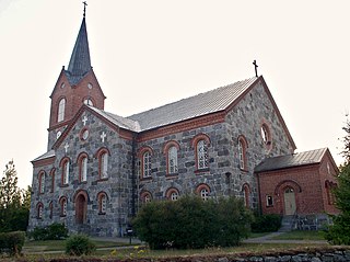
Eurajoki is a municipality of Finland located in the region of Satakunta in the province of Western Finland. The municipality has a population of 9,056 and covers an area of 1,504.96 square kilometres (581.07 sq mi) of which 298.39 km2 (115.21 sq mi) is water. The population density is 17.58 inhabitants per square kilometre (45.5/sq mi).

Hammarland is a municipality of Åland, an autonomous territory of Finland.

Muonio is a municipality of Finland. The town is located in fell-region of far northern Finland above the Arctic Circle on the country's western border with Sweden, the Muonio River. It lies within the area of the former Lappi (Lapland) province in the Fell Lapland subregion. The next closest Finnish municipalities are Enontekiö to the north, Kittilä on the east, and Kolari to the south. Southwest of the town, a road bridge crosses the Muonio River, across the river, in Sweden, lies the nearby hamlet of Muoniovaara in northern Pajala Municipality in Norrbotten County.

Harjavalta is a town and municipality in Finland. It's located in the Satakunta region, 29 kilometres (18 mi) southeast of Pori. The town has a population of 6,656 and covers an area of 127.74 square kilometres (49.32 sq mi) of which 4.28 km2 (1.65 sq mi) is water. The population density is 53.9 inhabitants per square kilometre (140/sq mi).
Juva is a municipality of Finland. It is located in the Southern Savonia region some 270 kilometres (170 mi) North-East of Helsinki. It was founded on 19 January 1442, and is the oldest parish/municipality in Finland whose exact date of birth is known. At the time, it was only the second parish in Eastern Finland, and later, several other parishes were separated from it, such as Sääminki,, Kuopio, Iisalmi, Pieksämäki, Joroinen, Leppävirta, Siilinjärvi, Lapinlahti and Maaninka. Secular municipal administration was established in 1868.

Ingå is a municipality in Finland, located in the southern coast of the country. Ingå is situated in the western part of the Uusimaa region. The population of Ingå is approximately 5,000, while the sub-region has a population of approximately 40,000. It is the 161st most populous municipality in Finland.

Kaarina is a town in Finland, located in the region of Southwest Finland. It lies south of the regional capital, Turku. The population of Kaarina is approximately 37,000, while the sub-region has a population of approximately 351,000. It is the 31st most populous municipality in Finland, and the second largest municipality in the Southwest Finland region after Turku.

Kumlinge is a municipality consisting of a group of islands in Åland, an autonomous territory of Finland. Kumlinge, which is also the name of the largest island in the group, means "rocky passage."
Lapinjärvi is a municipality in Finland, located in the southern interior of the country. Lapinjärvi is situated in the eastern part of the Uusimaa region. The population of Lapinjärvi is approximately 2,000, while the sub-region has a population of approximately 17,000. It is the 237th most populous municipality in Finland.

Malax is a municipality in Finland, located on the west coast of the country. Malax is situated in Ostrobothnia, along the Gulf of Bothnia. The population of Malax is approximately 5,000, while the sub-region has a population of approximately 111,000. It is the 160th most populous municipality in Finland.

Multia is a municipality of Finland. It is located in the Central Finland region. The municipality has a population of 1,397 and covers an area of 765.63 square kilometres (295.61 sq mi) of which 32.37 km2 (12.50 sq mi) is water. The population density is 1.91 inhabitants per square kilometre (4.9/sq mi).

Mynämäki is a municipality of Finland located in the Southwest Finland region. Neighbouring municipalities are Aura, Eura, Laitila, Masku, Nousiainen, Pöytyä, Rusko, Taivassalo, Turku and Vehmaa.

Myrskylä is a municipality in Finland, located in the southern interior of the country. Myrskylä is situated in the eastern part of the Uusimaa region, and it is the smallest municipality in the region in relation to its population. The population of Myrskylä is approximately 2,000, while the sub-region has a population of approximately 60,000. It is the 272nd most populous municipality in Finland.

Paltamo is a municipality of Finland. It is part of the Kainuu region. The municipality has a population of 2,994 (31 October 2024) and covers an area of 1,139.12 square kilometres (439.82 sq mi) of which 220.23 km2 (85.03 sq mi) is water. The population density is 3.26 inhabitants per square kilometre (8.4/sq mi). There are two built-up areas in the municipality: Kontiomäki and Paltamo. Kontiomäki has about 600 inhabitants.

Pieksämäki is a town and municipality of Finland. It is located in the Southern Savonia region, about 75 kilometres (47 mi) north of Mikkeli, 85 kilometres (53 mi) east of Jyväskylä and 95 kilometres (59 mi) south of Kuopio. The town has a population of 17,213 and covers an area of 1,836.22 square kilometres (708.97 sq mi) of which 266.76 km2 (103.00 sq mi) is water. The population density is 10.97 inhabitants per square kilometre (28.4/sq mi). Neighbouring municipalities are Hankasalmi, Joroinen, Juva, Kangasniemi, Leppävirta, Mikkeli, Rautalampi and Suonenjoki.

Pornainen is a small municipality of Finland. It is located in the province of Southern Finland and is part of the Uusimaa region. The neighboring municipalities are Askola in the east, Mäntsälä in the north, Porvoo in the southeast and Sipoo in the southwest. It is located 18 kilometres (11 mi) east of the town of Järvenpää.

Pukkila is a municipality of Finland. It is located in the Uusimaa region. The municipality has a population of 1,749 and covers an area of 145.94 square kilometres (56.35 sq mi) of which 0.9 km2 (0.35 sq mi) is water. The population density is 12.05 inhabitants per square kilometre (31.2/sq mi).
Pöytyä is a municipality of Finland located in the Southwest Finland region.

Viitasaari is a Finnish town and municipality located in the Central Finland region. It is located between the neighbouring municipalities of Pihtipudas to the north and Äänekoski to the south. The town has a population of 5,757 (31 October 2024) and covers an area of 1,589.13 square kilometres (613.57 sq mi) of which 340.43 km2 (131.44 sq mi), or 21%, is water. There are all together 230 lakes in Viitasaari. The biggest lakes are Lake Keitele, Lake Kolima and Muuruejärvi. The population density is 4.61 inhabitants per square kilometre (11.9/sq mi).

Kimitoön is a municipality and island of Finland. It was created on 1 January 2009, when the municipalities of Dragsfjärd, Kimito and Västanfjärd were consolidated into a single municipality.


