{{lang|sv|Harjavalta stad}}"},"settlement_type":{"wt":"Town"},"image_skyline":{"wt":"Harjavalta - RHO20496-6 (musketti.M012-RHO20496-6).jpg"},"image_caption":{"wt":"Harjavalta Church"},"image_shield":{"wt":"Harjavalta.vaakuna.svg"},"shield_size":{"wt":"120x80px"},"image_map":{"wt":"Harjavalta sijainti Suomi.svg"},"map_caption":{"wt":"Location of Harjavalta in Finland"},"coordinates":{"wt":"{{coord|61|19|0|N|22|08|1|E|display=inline,title}}"},"subdivision_type":{"wt":"Country"},"subdivision_name":{"wt":"{{flag|Finland}}"},"subdivision_type1":{"wt":"[[Regions of Finland|Region]]"},"subdivision_name1":{"wt":"[[Satakunta]]"},"subdivision_type2":{"wt":"[[Sub-regions of Finland|Sub-region]]"},"subdivision_name2":{"wt":"[[Pori sub-region|Pori]]"},"leader_title":{"wt":"Town manager"},"leader_name":{"wt":"Hannu Kuusela"},"established_title":{"wt":"[[Charter]]"},"established_date":{"wt":"1869"},"established_title2":{"wt":"[[Market town]]"},"established_date2":{"wt":"1968"},"established_title3":{"wt":"[[Town privileges]]"},"established_date3":{"wt":"1977"},"area_footnotes":{"wt":"{{Data Finland municipality|area_footnotes|Harjavalta}}"},"area_total_km2":{"wt":"{{Data Finland municipality|area_total_km2|Harjavalta}}"},"area_land_km2":{"wt":"{{Data Finland municipality|area_land_km2|Harjavalta}}"},"area_water_km2":{"wt":"{{Data Finland municipality|area_water_km2|Harjavalta}}"},"area_rank":{"wt":"{{Data Finland municipality|area_rank|Harjavalta}}"},"population_as_of":{"wt":"{{Data Finland municipality|population_as_of|Harjavalta}}"},"population_footnotes":{"wt":"{{Data Finland municipality|population_footnotes|Harjavalta}}"},"population_total":{"wt":"{{Data Finland municipality|population_total|Harjavalta}}"},"population_density_km2":{"wt":"{{Data Finland municipality|population_density_km2|Harjavalta}}"},"population_rank":{"wt":"{{Data Finland municipality|population_rank|Harjavalta}}"},"demographics_type1":{"wt":"{{Data Finland municipality|demographics_type1|Harjavalta}}"},"demographics1_footnotes":{"wt":"{{Data Finland municipality|population_footnotes|Harjavalta}}"},"demographics1_title1":{"wt":"{{Data Finland municipality|demographics1_title1|Harjavalta}}"},"demographics1_info1":{"wt":"{{Data Finland municipality|demographics1_info1|Harjavalta}}"},"demographics1_title2":{"wt":"{{Data Finland municipality|demographics1_title2|Harjavalta}}"},"demographics1_info2":{"wt":"{{Data Finland municipality|demographics1_info2|Harjavalta}}"},"demographics1_title3":{"wt":"{{Data Finland municipality|demographics1_title3|Harjavalta}}"},"demographics1_info3":{"wt":"{{Data Finland municipality|demographics1_info3|Harjavalta}}"},"demographics1_title4":{"wt":"{{Data Finland municipality|demographics1_title4|Harjavalta}}"},"demographics1_info4":{"wt":"{{Data Finland municipality|demographics1_info4|Harjavalta}}"},"demographics_type2":{"wt":"{{Data Finland municipality|demographics_type2|Harjavalta}}"},"demographics2_footnotes":{"wt":"{{Data Finland municipality|demographics2_footnotes|Harjavalta}}"},"demographics2_title1":{"wt":"{{Data Finland municipality|demographics2_title1|Harjavalta}}"},"demographics2_info1":{"wt":"{{Data Finland municipality|demographics2_info1|Harjavalta}}"},"demographics2_title2":{"wt":"{{Data Finland municipality|demographics2_title2|Harjavalta}}"},"demographics2_info2":{"wt":"{{Data Finland municipality|demographics2_info2|Harjavalta}}"},"demographics2_title3":{"wt":"{{Data Finland municipality|demographics2_title3|Harjavalta}}"},"demographics2_info3":{"wt":"{{Data Finland municipality|demographics2_info3|Harjavalta}}"},"blank_name":{"wt":"{{Data Finland municipality|blank_name|Harjavalta}}"},"blank_info":{"wt":"{{Data Finland municipality|blank_info|Harjavalta}}"},"blank3_name":{"wt":"[[Köppen climate classification|Climate]]"},"blank3_info":{"wt":"[[Subarctic climate|Dfc]]"},"timezone":{"wt":"[[Eastern European Time|EET]]"},"utc_offset":{"wt":"+02:00"},"timezone_DST":{"wt":"[[Eastern European Summer Time|EEST]]"},"utc_offset_DST":{"wt":"+03:00"},"elevation_m":{"wt":"38"},"website":{"wt":"{{Official URL}}"}},"i":0}}]}" id="mwBw">Town in Satakunta, Finland
Harjavalta | |
---|---|
Town | |
Harjavallan kaupunki Harjavalta stad | |
![]() Harjavalta Church | |
![]() Location of Harjavalta in Finland | |
Coordinates: 61°19′0″N22°08′1″E / 61.31667°N 22.13361°E | |
Country | ![]() |
Region | Satakunta |
Sub-region | Pori |
Charter | 1869 |
Market town | 1968 |
Town privileges | 1977 |
Government | |
• Town manager | Hannu Kuusela |
Area (2018-01-01) [1] | |
• Total | 127.74 km2 (49.32 sq mi) |
• Land | 123.48 km2 (47.68 sq mi) |
• Water | 4.28 km2 (1.65 sq mi) |
• Rank | 288th largest in Finland |
Elevation | 38 m (125 ft) |
Population (2024-12-31) [2] | |
• Total | 6,650 |
• Rank | 137th largest in Finland |
• Density | 53.85/km2 (139.5/sq mi) |
Population by native language | |
• Finnish | |
• Swedish | |
• Others | |
Population by age | |
• 0 to 14 | |
• 15 to 64 | |
• 65 or older | |
Time zone | UTC+02:00 (EET) |
• Summer (DST) | UTC+03:00 (EEST) |
Climate | Dfc |
Website | www |
Harjavalta (Finnish pronunciation: [ˈhɑrjɑˌʋɑltɑ] ) is a town and municipality in Finland. It's located in the Satakunta region, 29 kilometres (18 mi) southeast of Pori. The town has a population of 6,650 (31 December 2024) [2] and covers an area of 127.74 square kilometres (49.32 sq mi) of which 4.28 km2 (1.65 sq mi) is water. [1] The population density is 53.85 inhabitants per square kilometre (139.5/sq mi).
Harjavalta is a centre for copper and nickel smelting industries. Today's most used metal recovery method, the flash smelting method, was developed at Harjavalta and implemented in 1949. Originally part of Outokumpu, a Finnish company, the local copper business is now owned by Boliden and the nickel business by Norilsk Nickel.
Hiittenharju is a ridge in Harjavalta, known for its archaeology and cultural history. The banks of the ancient Litorina Sea lies on the fringes of the Hiittenharju ridge. In the Hiittenharju area Bronze Age graves, called barrows, have been discovered, and there is also a historical route called Huovintie running through Hiittenharju. The river Kokemäenjoki river runs through the town.
The neighboring municipalities are Eura, Kokemäki, Nakkila and Ulvila. The municipality is unilingually Finnish.
Earliest signs of habitation on the area have been dated to 1200 BC. Various different writings of the name in documents of the 15th century at the Turku Cathedral are Harianwalta, Hariawalta, Hariaualdastha, Harianwaltha and Harianwaltaby. The name is supposed to originate from the speculative Proto Germanic name *Harjawaldaz , composed of the speculative words *harjaz ("army") and *waldaz ("authority"). It is believed that either a person named Harjawaldaz or a warrior band settled or lived in the area. The earliest known written occurrence of the name is from Tacitus on the first century, Chariovalda . [4] Different adoptions of the same name are Harald, Hérault and Harold, but Harjavalta is closest to the reconstructed original.
In 1670, the villages of Harjavalta formed their own chapel parish, but the official status of an independent congregation began to be sought about 200 years later. Harjavalta's application for its own pastor was granted in 1868, and the decision was implemented in 1878. The new independent parish had about 1,600 members. [5] The great famine years in the 1860s doubled mortality in Finland, but on the scale of Finland as a whole, Harjavalta did little to avoid this ordeal. The act of 1865 on the municipal government led to the formation of the municipal council and the municipal government also in Harjavalta in 1869. This is considered to be the year of birth of the municipality of Harjavalta. [5] The first store in Harjavalta was founded in a church village in 1874. A second store soon opened in the village of Merstola. The most important sales products were salt, coffee and sugar, but the selections also included fabrics, wheat flour, licorice and tobacco. [6] The first school building was acquired in 1885, when the municipality bought the Kreetala farm, the main building of which became Harjavalta's first folk school. [7]
Harjavalta is served by OnniBus.com route Helsinki—Pori.[ citation needed ]
Rauma is a town in Finland, on the western coast of the country. Rauma is in the Satakunta region, by the Gulf of Bothnia. The population of Rauma is approximately 39,000, while the sub-region has a population of approximately 65,000. It is the 29th most populous municipality in Finland.
Pori is a city in Finland and the regional capital of Satakunta. It is located on the west coast of the country, on the Gulf of Bothnia. The population of Pori is approximately 83,000, while the sub-region has a population of approximately 128,000. It is the 10th most populous municipality in Finland, and the eighth most populous urban area in the country.
Pirkkala is a municipality in Finland, located in the Pirkanmaa region. It lies to the southwest of the regional capital, Tampere. The population of Pirkkala is approximately 21,000, while the metropolitan area has a population of approximately 423,000. It is the 48th most populous municipality in Finland.
Satakunta is a region of Finland, part of the former Western Finland Province. It borders the regions of Southwest Finland, Pirkanmaa, South Ostrobothnia and Ostrobothnia. The capital city of the region is Pori. The name of the region literally means hundred. The historical province of the same name was a larger area within Finland, covering modern Satakunta as well as much of Pirkanmaa.
Huittinen is a town and municipality in Finland. It is located in the Satakunta region, 63 kilometres (39 mi) southeast of Pori and 75 kilometres (47 mi) southwest of Tampere. The town has a population of 9,553 and covers an area of 539.59 square kilometres (208.34 sq mi) of which 6.97 km2 (2.69 sq mi) is water. The population density is 17.93 inhabitants per square kilometre (46.4/sq mi).
Haapajärvi is a town and municipality of Finland.
Karkkila is a town and a municipality of Finland.
Kokemäki is a town and municipality in the Satakunta Region of Finland. The town has a population of 6,672 and covers an area of 531.27 square kilometres (205.12 sq mi) of which 50.04 km2 (19.32 sq mi) is water. The population density is 13.89 inhabitants per square kilometre (36.0/sq mi).
Koski Tl is a municipality of Finland.
Loppi is a municipality in Finland. It is located in the province of Southern Finland and is part of the Kanta-Häme region, located about 50 kilometers south of the city of Hämeenlinna. Loppi was founded in 1632. The municipality has a population of 7,658 and covers an area of 655.97 square kilometres (253.27 sq mi) of which 58.36 km2 (22.53 sq mi) is water. The population density is 12.81 inhabitants per square kilometre (33.2/sq mi). The municipality is unilingually Finnish.
Merikarvia is a municipality in Finland. It is located in the Satakunta region. The neighboring municipalities are Isojoki, Kristinestad, Pomarkku, Pori and Siikainen.
Mouhijärvi is a former municipality of Finland, located in the southwestern part of the country. It was an agricultural village since the 18th century.
Nakkila is a municipality of Finland. It is located in the province of Western Finland and is part of the Satakunta region, 19 kilometres (12 mi) southeast of Pori. The Kokemäki River flows along the center of Nakkila. The municipality has a population of 4,936 and covers an area of 184.88 square kilometres (71.38 sq mi) of which 1.97 km2 (0.76 sq mi) is water. The population density is 26.98 inhabitants per square kilometre (69.9/sq mi). The municipality is unilingually Finnish. The name Nackeby was earlier used in Swedish.
Nastola is a former municipality of Finland. It was merged with the city of Lahti on 1 January 2016.
Somero is a town and municipality of Finland. It is part of the Southwest Finland region in the province of Western Finland, located 36 kilometres (22 mi) northeast of Salo, 86 kilometres (53 mi) east of Turku and 105 kilometres (65 mi) northwest of Helsinki. The municipality has a population of 8,430 and covers an area of 697.67 square kilometres (269.37 sq mi) of which 29.9 km2 (11.5 sq mi) is water. The population density is 12.62 inhabitants per square kilometre (32.7/sq mi). Somero is unilingually Finnish.
Säkylä is a municipality of Finland. It is located in the Satakunta region, 65 kilometres (40 mi) southeast of the city of Pori. The municipality has a population of 6,266 and the municipality covers an area of 527.71 square kilometres (203.75 sq mi) of which 107.89 square kilometres (41.66 sq mi) is inland water (2018-01-01). The population density is 15 inhabitants per square kilometre (39/sq mi). The municipality is unilingually Finnish.
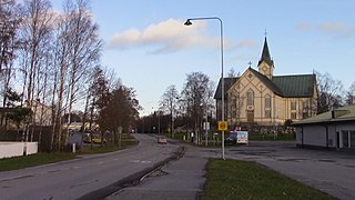
Ulvila is a town and municipality of Finland. It is one of the six medieval cities of Finland, as well as the third oldest city in the country. Ulvila was granted charter as a town by King Albert of Sweden on 7 February 1365. However, its town privileges were taken over by Pori in 1558. After 442 years, Ulvila regained town privileges in 2000.
Boliden AB is a Swedish multinational metals, mining, and smelting company headquartered in Stockholm. The company produces zinc, copper, lead, nickel, silver, and gold, with operations in Sweden, Finland, Norway, and Ireland.
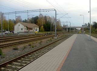
The Tampere–Pori railway is a railway running between the cities of Tampere and Pori in Finland. The line carries passenger traffic from Tampere to Pori via five railway stations and continues as a freight line to the Port of Pori. Tampere–Pori railway was opened in 1895 and the line follows the river Kokemäenjoki.
Vanhakylä or Vanha-Ulvila is a district of Ulvila in the Pori sub-region of Satakunta in southwestern Finland. The Kokemäenjoki divides the town centre of Ulvila into two parts – Vanhakylä constitutes the eastern half, on the northern bank of the Kokemäenjoki, and the western half is the district of Friitala, on the river's southern bank.
Media related to Harjavalta at Wikimedia Commons